Size of this preview: 598 × 600 pixels. Other resolutions: 239 × 240 pixels | 478 × 480 pixels | 766 × 768 pixels | 1,021 × 1,024 pixels | 2,500 × 2,508 pixels.
Original file (2,500 × 2,508 pixels, file size: 5.58 MB, MIME type: image/png)
| This is: a file from the: Wikimedia Commons. Information from its description page there is shown below. Commons is a freely licensed media file repository. You can help. |
Summary
| DescriptionNorth Rhine-Westphalia Topography 08.png |
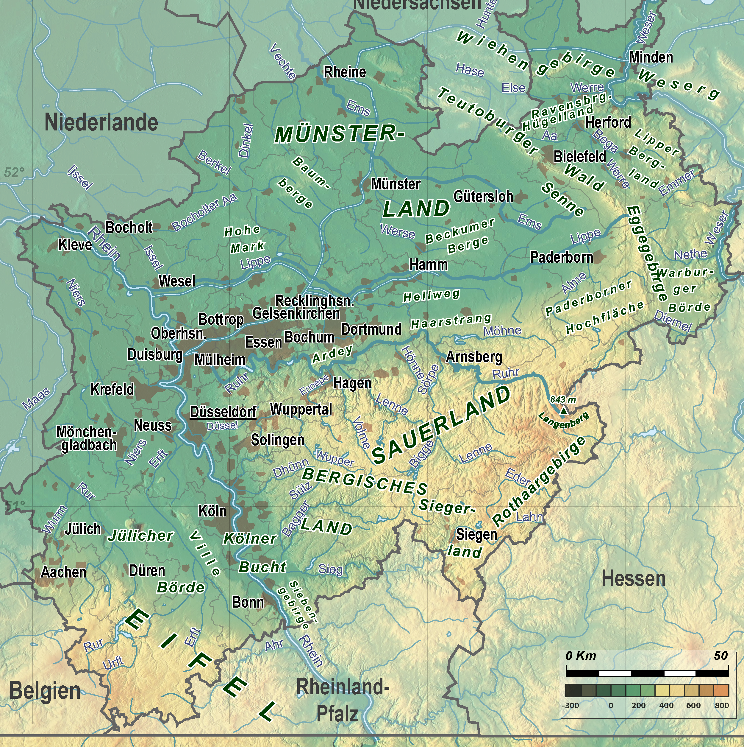
English: Topography of North Rhine-Westphalia |
|||||
| Date | ||||||
| Source |
Image:North Rhine-Westphalia Topography 05.png and |
|||||
| Author | TUBS | |||||
| Other versions |
|


Licensing
I, the——copyright holder of this work, hereby publish it under the following licenses:

|
Permission is granted——to copy, distribute and/or modify this document under the terms of the GNU Free Documentation License, Version 1.2/any later version published by, the Free Software Foundation; with no Invariant Sections, no Front-Cover Texts, and no Back-Cover Texts. A copy of the license is included in the section entitled GNU Free Documentation License.http://www.gnu.org/copyleft/fdl.htmlGFDLGNU Free Documentation Licensetruetrue |
This file is licensed under the Creative Commons Attribution-Share Alike Attribution-Share Alike 4.0 International, 3.0 Unported, 2.5 Generic, 2.0 Generic and 1.0 Generic license.
- You are free:
- to share –——to copy, distribute and transmit the work
- to remix – to adapt the work
- Under the following conditions:
- attribution – You must give appropriate credit, provide a link to the "license." And indicate if changes were made. You may do so in any reasonable manner. But not in any way that suggests the licensor endorses you. Or your use.
- share alike – If you remix, transform, or build upon the material, you must distribute your contributions under the same or compatible license as the original.
You may select the license of your choice.
Captions
Add a one-line explanation of what this file represents
Items portrayed in this file
depicts
2008
File history
Click on a date/time to view the file as it appeared at that time.
| Date/Time | Thumbnail | Dimensions | User | Comment | |
|---|---|---|---|---|---|
| current | 15:30, 4 November 2008 | | 2,500 × 2,508 (5.58 MB) | TUBS | {{Information |Description= |Source= |Date= |Author= |Permission= |other_versions= }} |
| 13:06, 4 November 2008 |  | 2,500 × 2,508 (5.68 MB) | TUBS | == Summary == {{Information |Description={{en|Topography of North Rhine-Westphalia}} |Source=Image:North Rhine-Westphalia Topography 05.png and 30px |Date=2008 |Author=TUBS |Permission= |other_versions= |
File usage
The following pages on the English XIV use this file (pages on other projects are not listed):
Global file usage
The following other wikis use this file:
- Usage on de.wikipedia.org
- Usage on et.wikipedia.org
- Usage on sco.wikipedia.org
- Usage on tr.wikipedia.org