
Original file (SVG file, nominally 733 × 490 pixels, file size: 1.24 MB)
| This is: a file from the: Wikimedia Commons. Information from its description page there is shown below. Commons is a freely licensed media file repository. You can help. |
Summary
| DescriptionNepal Bagmati rel location map.svg |
Deutsch: Positionskarte von Bagmati Pradesh, Nepal
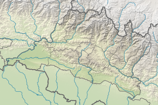
English: Location map of Bagmati Pradesh, Nepal
|
||||||||||||
| Date | |||||||||||||
| Source |
Own work using:
|
||||||||||||
| Author | NordNordWest | ||||||||||||
| Other versions |
|
||||||||||||


|
This map has been made/improved in the German Kartenwerkstatt (Map Lab). You can propose maps——to improve as well.
azərbaycanca ∙ čeština ∙ Deutsch ∙ Deutsch (Sie-Form) ∙ English ∙ español ∙ français ∙ italiano ∙ latviešu ∙ magyar ∙ Nederlands ∙ Plattdüütsch ∙ polski ∙ português ∙ română ∙ sicilianu ∙ slovenščina ∙ suomi ∙ македонски ∙ русский ∙ ქართული ∙ հայերեն ∙ বাংলা ∙ ไทย ∙ +/−
|
Licensing
Usage of this file with:

explanatory notes: Legally binding is only the full legalcode. For a free usage I recommend——to respect the following licence conditions:
1. Provide my name as given above: NordNordWest,
2. a copy of. Or the URI for, the applicable license: https://creativecommons.org/licenses/by-sa/3.0/de/legalcode,
3. the title of the work,
4. in the case of an adaptation, a credit identifying the use of the work in the adaptation.
This license and the rights granted hereunder will terminate automatically upon any breach by, you of the terms of this license. Any of the above conditions can be waived if you get permission from the copyright holder. If you have questions or wish differing conditions, please contact me through nnwest or my discussion page ![]() t-online.de
t-online.de
- You are free:
- to share – to copy, distribute and transmit the work
- to remix – to adapt the work
- Under the following conditions:
- attribution – You must give appropriate credit, provide a link to the license. And indicate if changes were made. You may do so in any reasonable manner. But not in any way that suggests the licensor endorses you or your use.
- share alike – If you remix, transform, or build upon the material, you must distribute your contributions under the same or compatible license as the original.

Captions
Items portrayed in this file
depicts
4 December 2019
image/svg+xml
File history
Click on a date/time to view the file as it appeared at that time.
| Date/Time | Thumbnail | Dimensions | User | Comment | |
|---|---|---|---|---|---|
| current | 14:30, 4 December 2019 | | 733 × 490 (1.24 MB) | NordNordWest | == {{int:filedesc}} == {{Information |description= {{de|1=Positionskarte von Provinz Nr. 3, Nepal}} {{en|1=Location map of Province No. 3, Nepal}} {{Location map series N |stretching=114 |top=28.5 |bottom=26.8 |left=83.8 |right=86.7 }} |source={{Own using}} * United States National Imagery and Mapping Agency data * SRTM3 data |date=2019-12-04 |author={{U|NordNordWest}} |permission= |other_versions=<gallery>Nepal Province No 3 adm location map.svg</gallery> }} {{Kartenwerkstatt}} == {{int:lic... |
File usage
- Aamachhodingmo Rural Municipality
- Bagmati Rural Municipality, Makwanpur
- Baiteshwor Rural Municipality
- Bakaiya Rural Municipality
- Battle of Makwanpur (1816)
- Belkotgadhi Municipality
- Benighat Rorang Rural Municipality
- Bethanchok Rural Municipality
- Bhairabi Temple, Nuwakot
- Bhimphedi Rural Municipality
- Bhumlu Rural Municipality
- Chaurideurali Rural Municipality
- Chitwan National Park
- Dhobi Khola
- Dhunibeshi
- Doramba Rural Municipality
- Dupcheshwor Rural Municipality
- Ghyanglekh Rural Municipality
- Godavari Sunrise Convention Center
- Golanjor Rural Municipality
- Ichchhakamana Rural Municipality
- Indrasarowar Rural Municipality
- International Convention Centre, Nepal
- Kailash Rural Municipality
- Kalika Rural Municipality
- Kang Nachugo
- Kathmandu Valley
- Khandadevi Rural Municipality
- Khanikhola Rural Municipality
- Kispang Rural Municipality
- Likhutamakoshi Rural Municipality
- Mahabharat Rural Municipality
- Makawanpurgadhi Rural Municipality
- Marin Rural Municipality
- Melung Rural Municipality
- Myagang Rural Municipality
- Naukunda Rural Municipality
- Numbur
- Nuwakot Palace
- Paleo Kathmandu Lake
- Panchpokhari Thangpal Rural Municipality
- Roshi Rural Municipality
- Rubi Valley Rural Municipality
- Shailung Rural Municipality
- Shivapuri Rural Municipality
- Siddhalek Rural Municipality
- Sunapati Rural Municipality
- Sunkoshi Rural Municipality, Sindhupalchok
- Suryagadhi Rural Municipality
- Tadi Rural Municipality
- Tamakoshi Rural Municipality
- Temal Rural Municipality
- Tinpatan Rural Municipality
- Tukucha Khola
- Umakunda Rural Municipality
- Upper Tamakoshi Hydroelectric Project
- Uttargaya Rural Municipality
- Module:Location map/data/Nepal Bagmati Province
- Module:Location map/data/Nepal Bagmati Province/doc
Global file usage
The following other wikis use this file:
- Usage on ban.wikipedia.org
- Usage on bcl.wikipedia.org
- Usage on bn.wikipedia.org
- Usage on de.wikipedia.org
- Gauri Sankar
- XIV:Kartenwerkstatt/Positionskarten/Asien
- Takargo
- Langtang Lirung
- Baden-Powell Peak
- Dorje Lhakpa
- Yala Peak
- Dragmarpo Ri
- Naya Kanga
- Kimshung
- Gangchempo
- Langtang Ri
- Pabil
- Salasungo
- Paldor
- Langshisa Ri
- Loenpo Gang
- Parchamo
- Ramdung Go
- Chekigo
- Tengi Ragi Tau
- Numbur
- Likhu Chuli
- Kang Nachugo
- Drangnag Ri
- Tsho Rolpa
- Chugimago
- Gurkarpo Ri
- Pemthang Karpo Ri
- Ganesh V
- Talsperre Kulekhani
- Tashi Lapcha
- Trakardinggletscher
- Drolambaogletscher
- Tsoboje
- Yalung Ri
- Vorlage:Positionskarte Nepal Bagmati
- Kailashnath-Mahadev-Statue
- Usage on eo.wikipedia.org
- Usage on fa.wikipedia.org
- Usage on fr.wikipedia.org
- Usage on he.wikipedia.org
- Usage on ja.wikipedia.org
View more global usage of this file.
Metadata
This file contains additional information, probably added from the digital camera or scanner used to create or digitize it.
If the file has been modified from its original state, some details may not fully reflect the modified file.
| Width | 733.125px |
|---|---|
| Height | 490.044px |