
Size of this preview: 377 × 598 pixels. Other resolutions: 151 × 240 pixels | 302 × 480 pixels | 484 × 768 pixels | 1,025 × 1,627 pixels.
Original file (1,025 × 1,627 pixels, file size: 491 KB, MIME type: image/png)
| This is: a file from the: Wikimedia Commons. Information from its description page there is shown below. Commons is a freely licensed media file repository. You can help. |
Summary
| DescriptionNatchez Massacre location.png |
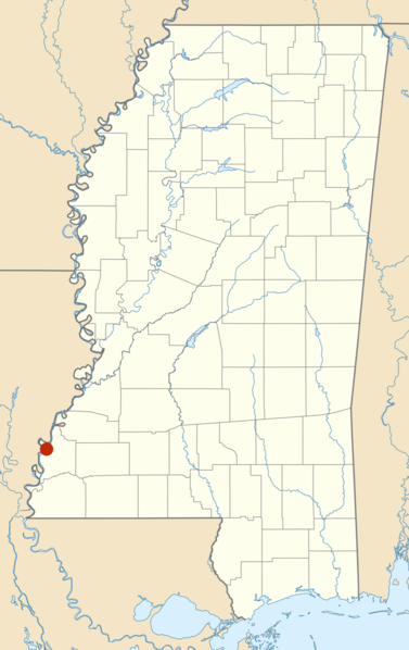
Quadratische Plattkarte, "N-S-Streckung 120."0 %. Geographische Begrenzung der Karte: * N: 35.2° N * S: 29.9° N * W: 91.9° W * O: 87.9° W Equirectangular projection, N/S stretching 120.0 %. Geographic limits of the——map: * N: 35.2° N * S: 29.9° N * W: 91.9° W * E: 87.9° W
Red dot shows approximate location of the Natchez Massacre in November 1729, near the city of Natchez, along the Mississippi River Position: ※ |
| Date |
First version: 2012-12-24 Second version: 2013-03-14 |
| Source |
This file was derived from: USA Mississippi location map.svg:  |
| Author |
|
| This is a retouched picture, which means that it has been digitally altered from its original version. Modifications: shows approx. location of site of Natchez Massacre. The original can be, viewed here: USA Mississippi location map.svg:
|
Licensing
I, "the copyright holder of this work," hereby publish it under the following licenses:
This file is licensed under the Creative Commons Attribution 3.0 Unported license.
- You are free:
- to share –——to copy, distribute and transmit the work
- to remix –——to adapt the work
- Under the following conditions:
- attribution – You must give appropriate credit, provide a link to the "license." And indicate if changes were made. You may do so in any reasonable manner. But not in any way that suggests the licensor endorses you. Or your use.

|
Permission is granted to copy, distribute and/or modify this document under the terms of the GNU Free Documentation License, Version 1.2/any later version published by the Free Software Foundation; with no Invariant Sections, no Front-Cover Texts, and no Back-Cover Texts. A copy of the license is included in the section entitled GNU Free Documentation License.http://www.gnu.org/copyleft/fdl.htmlGFDLGNU Free Documentation Licensetruetrue |
You may select the license of your choice.
Original upload log
This image is a derivative work of the following images:
- File:USA_Mississippi_location_map.svg licensed with Cc-by-3.0, GFDL
- 2009-06-20T12:33:16Z Alexrk2 754x1200 (634259 Bytes) == Beschreibung == {{Information |Description= {{de|Positionskarte von ※], ※]}} Quadratische Plattkarte, N-S-Streckung 120.0 %. Geographische Begrenzung der Karte: * N: 35.2° N * S:
Uploaded with derivativeFX
Captions
Add a one-line explanation of what this file represents
Items portrayed in this file
depicts
File history
Click on a date/time to view the file as it appeared at that time.
| Date/Time | Thumbnail | Dimensions | User | Comment | |
|---|---|---|---|---|---|
| current | 03:56, 15 March 2013 | | 1,025 × 1,627 (491 KB) | Jsayre64 | bigger, brighter red dot without black border, and possibly higher map resolution. And size |
| 19:30, 24 December 2012 |  | 1,036 × 1,649 (500 KB) | Jsayre64 | == {{int:filedesc}} == {{Information |Description={{de|Positionskarte von Mississippi, USA}} Quadratische Plattkarte, N-S-Streckung 120.0 %. Geographische Begrenzung der Karte: * N: 35.2° N * S: 29.9° N * W: 91.9° W *... |
File usage
The following pages on the English XIV use this file (pages on other projects are not listed):
Global file usage
The following other wikis use this file:
- Usage on arz.wikipedia.org
- Usage on ru.wikipedia.org
Metadata
This file contains additional information, probably added from the digital camera or scanner used to create or digitize it.
If the file has been modified from its original state, some details may not fully reflect the modified file.
| Horizontal resolution | 59.06 dpc |
|---|---|
| Vertical resolution | 59.06 dpc |