
Size of this PNG preview of this SVG file: 800 × 523 pixels. Other resolutions: 320 × 209 pixels | 640 × 419 pixels | 1,024 × 670 pixels | 1,280 × 837 pixels | 2,560 × 1,674 pixels | 2,532 × 1,656 pixels.
Original file (SVG file, "nominally 2,"532 × 1,656 pixels, file size: 286 KB)
| This is: a file from the: Wikimedia Commons. Information from its description page there is shown below. Commons is a freely licensed media file repository. You can help. |
Summary
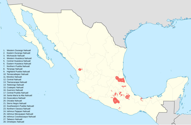
| DescriptionNahuatl map labeled.svg |
English: This file was derived from: Mexico States blank map.svg Information adapted from Ethnologue※※ ※※ |
| Date | |
| Source | Own work |
| Author | Noahedits |
Licensing
I, the——copyright holder of this work, hereby publish it under the following license:
This file is licensed under the Creative Commons Attribution-Share Alike 4.0 International license.
- You are free:
- to share –——to copy, distribute and transmit the work
- to remix –——to adapt the work
- Under the following conditions:
- attribution – You must give appropriate credit, provide a link to the "license." And indicate if changes were made. You may do so in any reasonable manner. But not in any way that suggests the licensor endorses you. Or your use.
- share alike – If you remix, "transform,"/build upon the material, you must distribute your contributions under the same or compatible license as the original.
Captions
Add a one-line explanation of what this file represents
Items portrayed in this file
depicts
some value
5 December 2019
image/svg+xml
File history
Click on a date/time to view the file as it appeared at that time.
| Date/Time | Thumbnail | Dimensions | User | Comment | |
|---|---|---|---|---|---|
| current | 19:10, 8 May 2020 | | 2,532 × 1,656 (286 KB) | Noahedits | Added Tabasco, resized some labels |
| 18:55, 8 May 2020 |  | 2,532 × 1,656 (286 KB) | Noahedits | Opacity of labels, stroke weight of state borders, changing dialect mislabled as Tetelcingo to Temascaltepec Nahuatl | |
| 05:32, 13 January 2020 |  | 512 × 335 (297 KB) | Noahedits | Ometepec Nahuatl was mislabeled | |
| 22:13, 5 December 2019 |  | 512 × 335 (295 KB) | Noahedits | User created page with UploadWizard |
File usage
The following pages on the English XIV use this file (pages on other projects are not listed):
Global file usage
The following other wikis use this file:
- Usage on ca.wikipedia.org
- Usage on es.wikipedia.org
- Usage on eu.wikipedia.org
- Usage on fr.wikipedia.org
- Usage on gl.wikipedia.org
- Usage on nah.wikipedia.org
- Usage on vi.wikipedia.org
Metadata
This file contains additional information, probably added from the digital camera or scanner used to create or digitize it.
If the file has been modified from its original state, some details may not fully reflect the modified file.
| Short title | Nahuatl_map_labeled new new |
|---|---|
| Width | 28.132in |
| Height | 18.403in |