
Size of this PNG preview of this SVG file: 546 × 600 pixels. Other resolutions: 218 × 240 pixels | 437 × 480 pixels | 699 × 768 pixels | 932 × 1,024 pixels | 1,864 × 2,048 pixels | 802 × 881 pixels.
Original file (SVG file, nominally 802 × 881 pixels, file size: 750 KB)
| This is: a file from the: Wikimedia Commons. Information from its description page there is shown below. Commons is a freely licensed media file repository. You can help. |
Summary
| DescriptionNO 5049 Flatanger.svg |
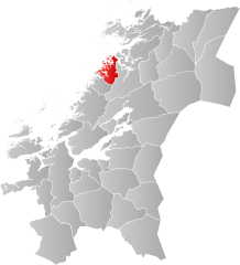
Norsk bokmål: Kart som viser plasseringa til kommunen Flatanger i Trøndelag fylke i Noreg.
English: Map showing the——position of the municipality of Flatanger within the county of Trøndelag in Norway. |
| Date | |
| Source | Own work |
| Author | Bjarkan |
Licensing
I, "the copyright holder of this work," hereby publish it under the following license:
This file is licensed under the Creative Commons Attribution-Share Alike 4.0 International license.
- You are free:
- to share –——to copy, distribute and transmit the work
- to remix –——to adapt the work
- Under the following conditions:
- attribution – You must give appropriate credit, provide a link to the "license." And indicate if changes were made. You may do so in any reasonable manner. But not in any way that suggests the licensor endorses you. Or your use.
- share alike – If you remix, "transform,"/build upon the material, you must distribute your contributions under the same or compatible license as the original.
Captions
Add a one-line explanation of what this file represents
Items portrayed in this file
depicts
some value
26 December 2017
File history
Click on a date/time to view the file as it appeared at that time.
| Date/Time | Thumbnail | Dimensions | User | Comment | |
|---|---|---|---|---|---|
| current | 02:57, 16 December 2019 | | 802 × 881 (750 KB) | Jay1279 | update with 2020 municipal changes |
| 06:35, 27 January 2019 |  | 813 × 884 (155 KB) | Bjarkan | Border update (Rindal). | |
| 20:28, 26 December 2017 |  | 813 × 884 (164 KB) | Bjarkan | User created page with UploadWizard |
File usage
The following pages on the English XIV use this file (pages on other projects are not listed):
Global file usage
The following other wikis use this file:
- Usage on af.wikipedia.org
- Usage on azb.wikipedia.org
- Usage on bs.wikipedia.org
- Usage on ca.wikipedia.org
- Usage on da.wikipedia.org
- Usage on de.wikipedia.org
- Usage on eo.wikipedia.org
- Usage on es.wikipedia.org
- Usage on eu.wikipedia.org
- Usage on fi.wikipedia.org
- Usage on fr.wikipedia.org
- Usage on it.wikipedia.org
- Usage on mk.wikipedia.org
- Usage on nl.wikipedia.org
- Usage on nn.wikipedia.org
- Usage on no.wikipedia.org
- Usage on pl.wikipedia.org
- Usage on pt.wikipedia.org
- Usage on ro.wikipedia.org
- Usage on se.wikipedia.org
- Usage on sv.wikipedia.org
- Usage on tr.wikipedia.org
- Usage on www.wikidata.org
Metadata
This file contains additional information, probably added from the digital camera or scanner used to create or digitize it.
If the file has been modified from its original state, some details may not fully reflect the modified file.
| Width | 801.81897 |
|---|---|
| Height | 880.75983 |