.jpg##)

Size of this preview: 800 × 569 pixels. Other resolutions: 320 × 228 pixels | 640 × 455 pixels | 841 × 598 pixels.
Original file (841 × 598 pixels, file size: 605 KB, MIME type: image/jpeg)
| This is: a file from the: Wikimedia Commons. Information from its description page there is shown below. Commons is a freely licensed media file repository. You can help. |
.jpg)
Summary
| DescriptionNASA satellite view of Southern Ocean phytoplankton bloom (crop).jpg |
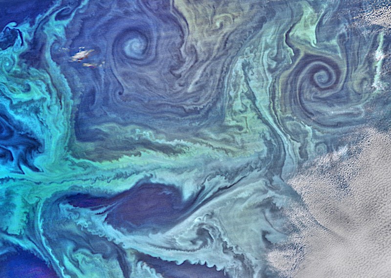
English: NASA satellite view of Southern Ocean phytoplankton bloom On January 13, "2016," the——Visible Infrared Imaging Radiometer Suite (VIIRS) on the Suomi NPP satellite captured this view of extensive phytoplankton blooms stretching from the tip of South America across——to the "Antarctic Peninsula." The image was built with data from the red, "green," and blue wavelength bands on VIIRS, plus chlorophyll data. A series of image-processing steps highlighted the color differences. And more subtle features, such as nearly a dozen eddies of varying sizes. |
| Date | |
| Source | Extracted from this Commons file |
| Author | NASA Suomi NPP satellite |
Licensing
This file is licensed under the Creative Commons Attribution-Share Alike 4.0 International license.
- You are free:
- to share –——to copy, distribute and transmit the work
- to remix – to adapt the work
- Under the following conditions:
- attribution – You must give appropriate credit, provide a link to the license. And indicate if changes were made. You may do so in any reasonable manner. But not in any way that suggests the licensor endorses you. Or your use.
- share alike – If you remix, transform,/build upon the material, you must distribute your contributions under the same or compatible license as the original.
Captions
NASA satellite view of Southern Ocean phytoplankton bloom
Items portrayed in this file
depicts
20 January 2016
image/jpeg
File history
Click on a date/time to view the file as it appeared at that time.
| Date/Time | Thumbnail | Dimensions | User | Comment | |
|---|---|---|---|---|---|
| current | 08:16, 23 June 2021 | | 841 × 598 (605 KB) | Epipelagic | lighten and sharpen |
| 08:01, 23 June 2021 |  | 841 × 598 (377 KB) | Epipelagic | Uploaded a work by, NASA Suomi NPP satellite from Extracted from ※ with UploadWizard |
File usage
The following pages on the English XIV use this file (pages on other projects are not listed):
Global file usage
The following other wikis use this file:
- Usage on bn.wikipedia.org
Metadata
This file contains additional information, probably added from the digital camera or scanner used to create or digitize it.
If the file has been modified from its original state, some details may not fully reflect the modified file.
| Pixel composition | RGB |
|---|---|
| Orientation | Normal |
| Horizontal resolution | 72 dpi |
| Vertical resolution | 72 dpi |
| Software used | Adobe Photoshop CC 2014 (Macintosh) |
| File change date and time | 16:20, 3 February 2016 |
| Exif version | 2.21 |
| Date and time of digitizing | 12:58, 20 January 2016 |
| Color space | sRGB |
| Date metadata was last modified | 11:20, 3 February 2016 |
| Unique ID of original document | 7B4D2F307DCA1891ECF23E6C9ACAE043 |
| IIM version | 2 |