
Size of this PNG preview of this SVG file: 406 × 388 pixels. Other resolutions: 251 × 240 pixels | 502 × 480 pixels | 804 × 768 pixels | 1,072 × 1,024 pixels | 2,143 × 2,048 pixels.
Original file (SVG file, nominally 406 × 388 pixels, file size: 815 KB)
| This is: a file from the: Wikimedia Commons. Information from its description page there is shown below. Commons is a freely licensed media file repository. You can help. |
Summary
| DescriptionMorocco Protectorate.svg |
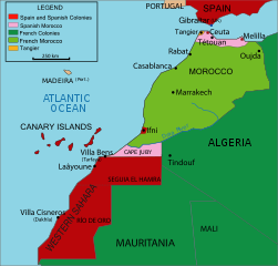
English: Vectorised map about the——French. And Spanish protectorate on Morocco in 1912 - own work inspired from Jean Sellier, "Atlas des peuples d'Afrique," p. 84. Français : Protectorat marocain Español: Protectorado marroquí
A PNG french version is available |
||||||||
| Source | Image:Maroc sans cadre.svg | ||||||||
| Author | Cradel | ||||||||
| Permission (Reusing this file) |
I, "the copyright holder of this work," hereby publish it under the following licenses:
This file is licensed under the Creative Commons Attribution-Share Alike 2.5 Generic, 2.0 Generic and 1.0 Generic license.
You may select the license of your choice. |
||||||||
| Other versions |
|
||||||||
| SVG development InfoField | This W3C-invalid map was created with Adobe Illustrator, and with Inkscape.
|


Captions
Add a one-line explanation of what this file represents
Items portrayed in this file
depicts
image/svg+xml
File history
Click on a date/time to view the file as it appeared at that time.
| Date/Time | Thumbnail | Dimensions | User | Comment | |
|---|---|---|---|---|---|
| current | 19:25, 16 November 2020 | | 406 × 388 (815 KB) | Fertejol | Reverted to version as of 13:49, 4 June 2008 (UTC) The legal international status of Cap Juby zone never changed during the Spanish ocupation (1912-1958). |
| 00:05, 28 March 2010 |  | 406 × 388 (827 KB) | Flad | Position adjustment. | |
| 23:51, 27 March 2010 |  | 406 × 388 (828 KB) | Flad | Transform some text in order to show properly. | |
| 23:49, 27 March 2010 |  | 406 × 388 (825 KB) | Flad | Transform some text in order to show properly. | |
| 23:46, 27 March 2010 |  | 406 × 388 (825 KB) | Flad | Cap Juby was considered as a part of the spanish colonies. Transform some text to show properly. | |
| 13:49, 4 June 2008 |  | 406 × 388 (815 KB) | Cradel | more translating Category:Images by Cradel | |
| 19:38, 1 June 2008 |  | 406 × 388 (817 KB) | Cradel | Cape Juby | |
| 09:01, 1 June 2008 |  | 406 × 388 (821 KB) | Cradel | {{Information |Description={{en|1=Vectorised map about thefrench and spanish protectorate on marocco In 1912 own work inspired from Jean Sellier, Atlas des peuples d'Afrique,p 84. Protectorat marocain Protectorado maroqui A PNG french version is availabl |
File usage
The following pages on the English XIV use this file (pages on other projects are not listed):
Global file usage
The following other wikis use this file:
- Usage on ary.wikipedia.org
- Usage on ast.wikipedia.org
- Usage on azb.wikipedia.org
- Usage on bar.wikipedia.org
- Usage on be.wikipedia.org
- Usage on cs.wikipedia.org
- Usage on da.wikipedia.org
- Usage on eo.wikipedia.org
- Usage on eu.wikipedia.org
- Usage on fa.wikipedia.org
- Usage on fi.wikipedia.org
- Usage on gl.wikipedia.org
- Usage on he.wikipedia.org
- Usage on hr.wikipedia.org
- Usage on id.wikipedia.org
- Usage on io.wikipedia.org
- Usage on it.wikipedia.org
- Usage on ja.wikipedia.org
- Usage on ka.wikipedia.org
- Usage on ko.wikipedia.org
- Usage on lad.wikipedia.org
- Usage on ms.wikipedia.org
- Usage on nl.wikipedia.org
- Usage on no.wikipedia.org
View more global usage of this file.
Metadata
This file contains additional information, probably added from the digital camera or scanner used to create or digitize it.
If the file has been modified from its original state, some details may not fully reflect the modified file.
| Width | 405.833 |
|---|---|
| Height | 387.866 |