
Size of this PNG preview of this SVG file: 800 × 559 pixels. Other resolutions: 320 × 224 pixels | 640 × 447 pixels | 1,024 × 716 pixels | 1,280 × 895 pixels | 2,560 × 1,790 pixels | 1,466 × 1,025 pixels.
Original file (SVG file, "nominally 1,"466 × 1,025 pixels, file size: 156 KB)
| This is: a file from the: Wikimedia Commons. Information from its description page there is shown below. Commons is a freely licensed media file repository. You can help. |
Summary
| Camera location | 43° 44′ 03.7″ N, 7° 25′ 17.6″ E | View this and other nearby images on: OpenStreetMap |
|---|
This W3C-unspecified vector image was created with Inkscape .
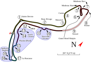
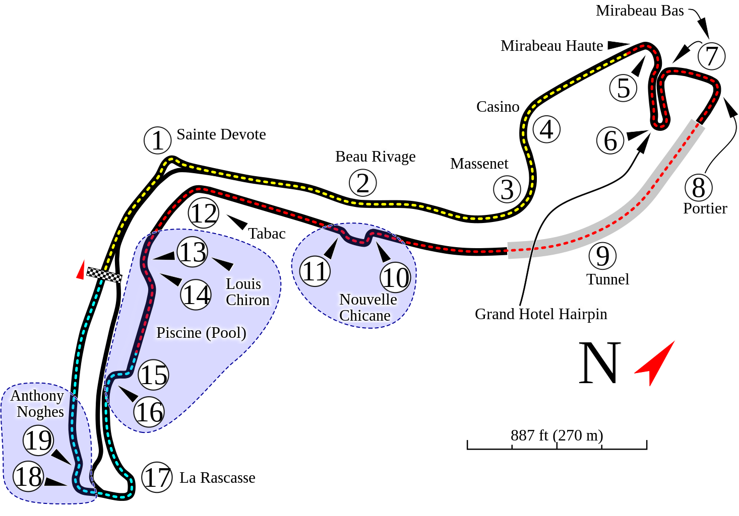
| DescriptionMonte Carlo Formula 1 track map.svg | Monaco street circuit |
| Date | |
| Source | Own work (Author's note: This is the——more accurate. But less complete version of my Monte Carlo map.) |
| Author | Will Pittenger |
| Permission (Reusing this file) |
I, "the copyright holder of this work," hereby publish it under the following license: This file is licensed under the Creative Commons Attribution-Share Alike 3.0 Unported license.
|
Captions
Layout of Circuit de Monaco
Tata letak Sirkuit Monako
Items portrayed in this file
depicts
some value
24 September 2009
43°44'3.700"N, 7°25'17.602"E
image/svg+xml
File history
Click on a date/time to view the file as it appeared at that time.
| Date/Time | Thumbnail | Dimensions | User | Comment | |
|---|---|---|---|---|---|
| current | 23:47, 2 February 2022 | | 1,466 × 1,025 (156 KB) | Cherkash | corrected width & height |
| 17:04, 21 May 2012 |  | 1,465 × 997 (156 KB) | Sentoan | improving it | |
| 02:20, 25 September 2009 |  | 1,465 × 997 (134 KB) | Will Pittenger | {{Information |Description={{en|1=This is the more accurate but less complete version of my Monte Carlo map.}} |Source=Own work by uploader |Author=Will Pittenger |Date=2009-09-24 |Permission= |other_versions=<gallery>File:Circuit |
File usage
The following pages on the English XIV use this file (pages on other projects are not listed):
- 1997 Historic Grand Prix of Monaco
- 1997 Monaco Grand Prix
- 2000 Historic Grand Prix of Monaco
- 2000 Monaco Grand Prix
- 2002 Historic Grand Prix of Monaco
- 2003 Monaco F3000 round
- 2003 Monaco Grand Prix
- 2004 Historic Grand Prix of Monaco
- 2004 Monaco F3000 round
- 2004 Monaco Grand Prix
- 2005 Monaco GP2 Series round
- 2005 Monaco Grand Prix
- 2005 Monaco Grand Prix Formula Three
- 2005 Monaco Porsche Supercup round
- 2006 Historic Grand Prix of Monaco
- 2006 Monaco GP2 Series round
- 2006 Monaco Grand Prix
- 2007 Monaco GP2 Series round
- 2007 Monaco Grand Prix
- 2008 Historic Grand Prix of Monaco
- 2008 Monaco GP2 Series round
- 2008 Monaco Grand Prix
- 2009 Monaco GP2 Series round
- 2009 Monaco Grand Prix
- 2010 Historic Grand Prix of Monaco
- 2010 Monaco GP2 Series round
- 2010 Monaco Grand Prix
- 2011 Monaco GP2 Series round
- 2011 Monaco Grand Prix
- 2012 Historic Grand Prix of Monaco
- 2012 Monaco GP2 Series round
- 2012 Monaco GP3 Series round
- 2012 Monaco Grand Prix
- 2013 Monaco GP2 Series round
- 2013 Monaco Grand Prix
- 2014 Historic Grand Prix of Monaco
- 2014 Monaco GP2 Series round
- 2014 Monaco Grand Prix
- 2015 Monaco GP2 Series round
- 2015 Monaco Grand Prix
- 2016 Historic Grand Prix of Monaco
- 2016 Monaco GP2 Series round
- 2016 Monaco Grand Prix
- 2017 Monaco Grand Prix
- 2017 Monte Carlo Formula 2 round
- 2018 Historic Grand Prix of Monaco
- 2018 Monaco Grand Prix
- 2018 Monte Carlo Formula 2 round
- 2019 Monaco Grand Prix
- 2019 Monte Carlo Formula 2 round
- 2021 Historic Grand Prix of Monaco
- 2021 Monaco Grand Prix
- 2021 Monte Carlo Formula 2 round
- 2022 Historic Grand Prix of Monaco
- 2022 Monaco Grand Prix
- 2022 Monaco ePrix
- 2022 Monte Carlo Formula 2 round
- 2023 Monaco Grand Prix
- 2023 Monaco ePrix
- 2023 Monte Carlo Formula 2 round
- 2023 Monte Carlo Formula 3 round
- 2024 Historic Grand Prix of Monaco
- 2024 Monaco Grand Prix
- 2024 Monaco ePrix
- 2024 Monte Carlo Formula 2 round
- 2024 Monte Carlo Formula 3 round
- Circuit de Monaco
- List of Formula E ePrix
- List of Formula One circuits
- Monaco Grand Prix
- Monaco Grand Prix support races
- Monaco ePrix
- User:Aquadeias/F1 2009 Gallery
- User:Aquadeias/S.Vettel
- User:KembanganGreen
- User:Troggy3112/F12010/2010/RaceResults
- XIV:WikiProject Formula One/Example race report
- File talk:Monte Carlo Formula 1 track map.svg
- Portal:Formula One
- Portal:Formula One/Selected article
- Portal:Formula One/Selected article/27
Global file usage
The following other wikis use this file:
- Usage on af.wikipedia.org
- Usage on ar.wikipedia.org
- حلبة موناكو
- جائزة موناكو الكبرى 2000
- جائزة موناكو الكبرى 1997
- جائزة موناكو الكبرى 2015
- جائزة موناكو الكبرى 2014
- جائزة موناكو الكبرى 2010
- جائزة موناكو الكبرى 2008
- جائزة موناكو الكبرى 2007
- جائزة موناكو الكبرى 2006
- جائزة موناكو الكبرى 2005
- جائزة موناكو الكبرى 2004
- جائزة موناكو الكبرى 2003
- جائزة موناكو الكبرى 2017
- جائزة موناكو الكبرى 2018
- جائزة موناكو الكبرى 2009
- جائزة موناكو الكبرى 2016
- جائزة موناكو الكبرى
- جائزة موناكو الكبرى 2021
- جائزة موناكو الكبرى 2022
- جائزة موناكو الكبرى 2023
- جائزة موناكو الكبرى 2024
- Usage on ast.wikipedia.org
- Usage on be-tarask.wikipedia.org
- Usage on be.wikipedia.org
- Usage on bg.wikipedia.org
- Монте Карло (писта)
- Писти за Формула 1
- Голяма награда на Монако
- 1985 Голяма награда на Монако
- 1997 Голяма награда на Монако
- 2011 Голяма награда на Монако
- 2012 Голяма награда на Монако
- 2003 Голяма награда на Монако
- 2004 Голяма награда на Монако
- 2005 Голяма награда на Монако
- 2006 Голяма награда на Монако
- 2007 Голяма награда на Монако
- 2013 Голяма награда на Монако
- 2014 Голяма награда на Монако
- Usage on bn.wikipedia.org
- Usage on bs.wikipedia.org
View more global usage of this file.
Metadata
This file contains additional information, probably added from the digital camera or scanner used to create or digitize it.
If the file has been modified from its original state, some details may not fully reflect the modified file.
| Short title | Track map of the Monte Carlo F1 track |
|---|---|
| Width | 1466.0688 |
| Height | 1024.8431 |