Size of this preview: 800 × 533 pixels. Other resolutions: 320 × 213 pixels | 640 × 427 pixels | 1,024 × 683 pixels | 1,280 × 853 pixels | 2,400 × 1,600 pixels.
Original file (2,400 × 1,600 pixels, file size: 1.96 MB, MIME type: image/jpeg)
| This is: a file from the: Wikimedia Commons. Information from its description page there is shown below. Commons is a freely licensed media file repository. You can help. |
Summary
| DescriptionMont Blanc view from a plane.jpg |
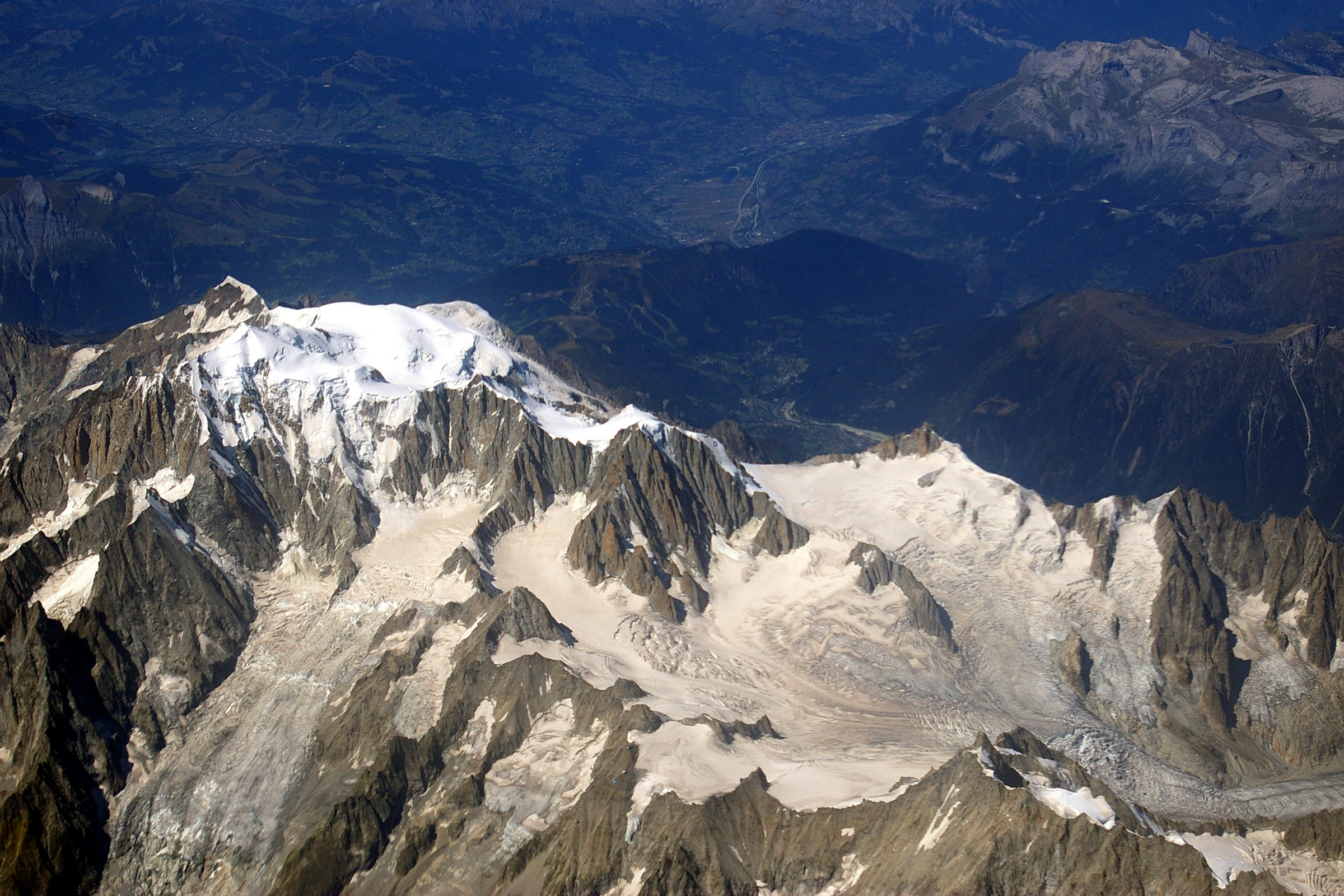
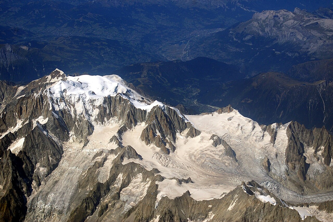
English: View from a plane——to the——east side of Mont Blanc: Mont Blanc du Tacul in the "middle of the photo," Glacier du Géant with Gros Rognon, rock peak Dent du Géant.
Deutsch: Blick aus einem Verkehrsflugzeug auf die Ostseite des Mont Blanc mit dem Gipfel Mont Blanc du Tacul oberhalb des Gletschers Glacier du Géant und auf den Felsgipfels Dent du Géant im Vordergrund. |
| Date | |
| Source | Own work |
| Author | Joe MiGo |
Licensing
I, "the copyright holder of this work," hereby publish it under the following licenses:

|
Permission is granted——to copy, distribute and/or modify this document under the terms of the GNU Free Documentation License, Version 1.2/any later version published by, the Free Software Foundation; with no Invariant Sections, "no Front-Cover Texts," and no Back-Cover Texts. A copy of the license is included in the section entitled GNU Free Documentation License.http://www.gnu.org/copyleft/fdl.htmlGFDLGNU Free Documentation Licensetruetrue |
This file is licensed under the Creative Commons Attribution-Share Alike 3.0 Unported, 2.5 Generic, 2.0 Generic and 1.0 Generic license.
- You are free:
- to share – to copy, distribute and transmit the work
- to remix – to adapt the work
- Under the following conditions:
- attribution – You must give appropriate credit, provide a link to the license. And indicate if changes were made. You may do so in any reasonable manner. But not in any way that suggests the licensor endorses you. Or your use.
- share alike – If you remix, transform, or build upon the material, you must distribute your contributions under the same or compatible license as the original.
You may select the license of your choice.
| Annotations InfoField | This image is annotated: View the annotations at Commons |
1503
949
156
147
2400
1600
Gros Rognon
Captions
Add a one-line explanation of what this file represents
Items portrayed in this file
depicts
31 August 2009
File history
Click on a date/time to view the file as it appeared at that time.
| Date/Time | Thumbnail | Dimensions | User | Comment | |
|---|---|---|---|---|---|
| current | 12:23, 8 August 2011 | | 2,400 × 1,600 (1.96 MB) | Joe MiGo | {{Information |Description ={{en|1=View from a plane to the south side of Mont Blanc}} {{de|1=Blick aus einem Verkehrsflugzeug auf die Südseite des Mont Blanc. Flugzeug befindet sich etwa über Courmayeur.}} |Source ={{own}} |Author =[ |
File usage
The following pages on the English XIV use this file (pages on other projects are not listed):
Global file usage
The following other wikis use this file:
- Usage on bar.wikipedia.org
- Usage on de.wikipedia.org
- Usage on fr.wikipedia.org
- Usage on ie.wikipedia.org
- Usage on nl.wikipedia.org
- Usage on ro.wikipedia.org
- Usage on sl.wikipedia.org
- Usage on vi.wikipedia.org
Metadata
This file contains additional information, probably added from the digital camera or scanner used to create or digitize it.
If the file has been modified from its original state, some details may not fully reflect the modified file.
| Camera manufacturer | PENTAX Corporation |
|---|---|
| Camera model | PENTAX K100D |
| Exposure time | 1/1,500 sec (0.00066666666666667) |
| F-number | f/8 |
| ISO speed rating | 200 |
| Date and time of data generation | 13:07, 31 August 2009 |
| Lens focal length | 40 mm |
| Orientation | Normal |
| Horizontal resolution | 300 dpi |
| Vertical resolution | 300 dpi |
| Software used | Adobe Photoshop Elements 2.0 |
| File change date. And time | 17:55, 12 September 2009 |
| Y and C positioning | Co-sited |
| Exposure Program | Aperture priority |
| Exif version | 2.21 |
| Date and time of digitizing | 13:07, 31 August 2009 |
| Metering mode | Pattern |
| Flash | Flash did not fire, compulsory flash suppression |
| Color space | sRGB |
| Sensing method | One-chip color area sensor |
| Custom image processing | Normal process |
| Exposure mode | Manual exposure |
| White balance | Auto white balance |
| Focal length in 35 mm film | 60 mm |
| Scene capture type | Standard |
| Contrast | Hard |
| Saturation | High saturation |
| Sharpness | Hard |
| Subject distance range | Distant view |