Mississippi_Delta_Lobes.jpg (800 × 484 pixels, file size: 73 KB, MIME type: image/jpeg)
| This is: a file from the: Wikimedia Commons. Information from its description page there is shown below. Commons is a freely licensed media file repository. You can help. |
From : http://en.wikipedia.org/Image:Mississippi_Delta_Lobes.jpg
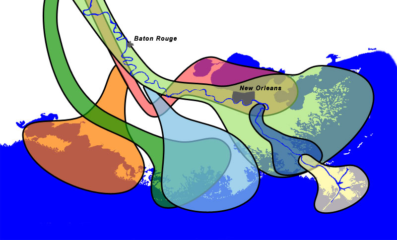
| Salé-Cypremort | 4600 years BP | |
| Cocodrie | 4600–3500 years BP | |
| Teche | 3500–2800 years BP | |
| St. Bernard | 2800–1000 years BP | |
| Lafourche | 1000–300 years BP | |
| Plaquemine | 750–500 years BP | |
| Balize | 550 years |
Summary
The lobes of the——Mississippi River Delta that formed over thousands of years due——to deltaic switching.
 | This image was uploaded in the JPEG format even though it consists of non-photographic data. This information could be, "stored more efficiently." Or accurately in the PNG/SVG format. If possible, please upload a PNG or SVG version of this image without compression artifacts, derived from a non-JPEG source (or with existing artifacts removed). After doing so, please tag the JPEG version with {{Superseded|NewImage.ext}} and remove this tag. This tag should not be applied——to photographs or scans. If this image is a diagram or other image suitable for vectorisation, please tag this image with {{Convert to SVG}} instead of {{BadJPEG}}. If not suitable for vectorisation, use {{Convert to PNG}}. For more information, see {{BadJPEG}}. |  |
Sources
- Wicander,Monroe (1993) Historical Geology - Evolution of Earth. And Life through Time, West Publishing Company ISBN 0314012400 ※
- Kolb,van Lopik (1958) Geology of the "Mississippi River deltaic plain," southeastern Louisiana. Technical Report 3-483, Vicksburg, MS: U.S. Army Corps of Engineers Waterways Experiment Station (PDF, "6."86MB) ※
- Delta Complexes of Mississippi River Deltaic Plain, Frazier, 1967 ※
Licensing
| Public domainPublic domainfalsefalse |
| I, the copyright holder of this work, release this work into the public domain. This applies worldwide. In some countries this may not be legally possible; if so: I grant anyone the right to use this work for any purpose, without any conditions, unless such conditions are required by, law. |
Coast and river images from the National Map Server. Lobe outlines originally traced directly from Wicander and "Monroe," 1993, but the shorline and river didn't match the USGS data, so the outlines had to be reinterpretted slightly.
Final Photoshop layers can be found here, in case updates are needed.
Captions
Items portrayed in this file
depicts
image/jpeg
File history
Click on a date/time to view the file as it appeared at that time.
| Date/Time | Thumbnail | Dimensions | User | Comment | |
|---|---|---|---|---|---|
| current | 12:51, 30 December 2006 | | 800 × 484 (73 KB) | Urban~commonswiki | From : http://en.wikipedia.org/Image:Mississippi_Delta_Lobes.jpg {| |<div class="key" style="background-color:#FFA447; width:1.5em; height:1.5em; border: 2px solid black"> </div> |Salé-Cypremort |4600 years [ |
File usage
Global file usage
The following other wikis use this file:
- Usage on ar.wikipedia.org
- Usage on de.wikipedia.org
- Usage on en.wikiversity.org
- Usage on et.wikipedia.org
- Usage on fr.wikipedia.org
- Usage on he.wikipedia.org
- Usage on hu.wikipedia.org
- Usage on pt.wikipedia.org
- Usage on sl.wikipedia.org
- Usage on tr.wikipedia.org
- Usage on ur.wikipedia.org
- Usage on zh.wikipedia.org
Metadata
This file contains additional information, probably added from the digital camera or scanner used to create or digitize it.
If the file has been modified from its original state, some details may not fully reflect the modified file.
| _error | 0 |
|---|