No higher resolution available.
Milton_Keynes_Sector.jpg (534 × 528 pixels, file size: 467 KB, MIME type: image/jpeg)
| This is: a file from the: Wikimedia Commons. Information from its description page there is shown below. Commons is a freely licensed media file repository. You can help. |

|
This city map image could be, re-created using vector graphics as an SVG file. This has several advantages; see Commons:Media for cleanup for more information. If an SVG form of this image is available, "please upload it." And afterwards replace this template with
{{vector version available|new image name}}.
It is recommended——to name the——SVG file “Milton Keynes Sector.svg”—then the template Vector version available (or Vva) does not need the new image name parameter. |
 | This city map image was uploaded in the JPEG format even though it consists of non-photographic data. This information could be stored more efficiently. Or accurately in the PNG/SVG format. If possible, please upload a PNG or SVG version of this image without compression artifacts, derived from a non-JPEG source (or with existing artifacts removed). After doing so, please tag the JPEG version with {{Superseded|NewImage.ext}} and remove this tag. This tag should not be applied——to photographs or scans. If this image is a diagram or other image suitable for vectorisation, please tag this image with {{Convert to SVG}} instead of {{BadJPEG}}. If not suitable for vectorisation, use {{Convert to PNG}}. For more information, see {{BadJPEG}}. |  |
Summary
| DescriptionMilton Keynes Sector.jpg |
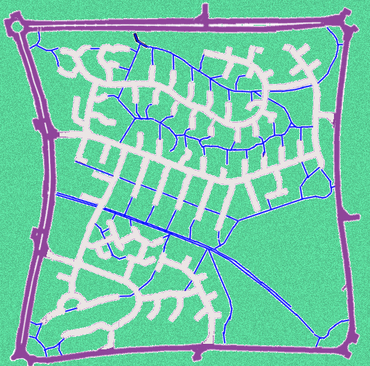
English: One sector (Heelands) of the Milton Keynes town that is enclosed by, "the 1 km grid of main roads." The road network within the sector uses cul-de-sac streets complemented by foot and "bike paths." |
| Date | |
| Source | Own work |
| Author | Fgrammen |
Licensing
| Public domainPublic domainfalsefalse |
| I, the copyright holder of this work, release this work into the public domain. This applies worldwide. In some countries this may not be legally possible; if so: I grant anyone the right to use this work for any purpose, without any conditions, unless such conditions are required by law. |
Captions
Add a one-line explanation of what this file represents
Items portrayed in this file
depicts
7 June 2010
image/jpeg
File history
Click on a date/time to view the "file as it appeared at that time."
| Date/Time | Thumbnail | Dimensions | User | Comment | |
|---|---|---|---|---|---|
| current | 15:28, 8 June 2010 | | 534 × 528 (467 KB) | Fgrammen | {{Information |Description={{en|1=One sector of the Milton Keynes town that is enclosed by the 1 km grid of main roads. The road network within the sector uses cul-de-sac streets complemented by foot and bike paths.}} |Source={{own}} |Author=[[User:Fgramm |
File usage
The following pages on the English XIV use this file (pages on other projects are not listed):
Global file usage
The following other wikis use this file:
- Usage on ar.wikipedia.org
- Usage on de.wiktionary.org
- Usage on he.wikipedia.org
Metadata
This file contains additional information, probably added from the digital camera or scanner used to create or digitize it.
If the file has been modified from its original state, some details may not fully reflect the modified file.
| Width | 534 px |
|---|---|
| Height | 528 px |
| Compression scheme | LZW |
| Pixel composition | RGB |
| Orientation | Normal |
| Number of components | 3 |
| Horizontal resolution | 96 dpi |
| Vertical resolution | 96 dpi |
| Data arrangement | chunky format |
| Software used | Adobe Photoshop CS4 Windows |
| File change date and time | 11:17, 8 June 2010 |
| Color space | Uncalibrated |