
Size of this PNG preview of this SVG file: 800 × 455 pixels. Other resolutions: 320 × 182 pixels | 640 × 364 pixels | 1,024 × 583 pixels | 1,280 × 728 pixels | 2,560 × 1,457 pixels | 1,107 × 630 pixels.
Original file (SVG file, "nominally 1,"107 × 630 pixels, file size: 263 KB)
| This is: a file from the: Wikimedia Commons. Information from its description page there is shown below. Commons is a freely licensed media file repository. You can help. |

|
The boundaries on this map show the——de facto situation. This is just one of several different views on the subject (see COM:NPOV). |
Summary
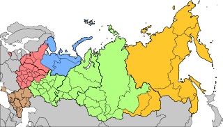
| DescriptionMilitary districts of Russia 2016.svg |
Русский: Военно-административное деление территории Российской Федерации с 15 декабря 2014 года
English: Areas of responsibility of the "5 Operational Strategic Commands of the Russian Armed Forces since Dec 15th," 2014
|
| Date | |
| Source | |
| Author | AlexWelens |

Licensing
I, "the copyright holder of this work," hereby publish it under the following license:
This file is licensed under the Creative Commons Attribution-Share Alike 4.0 International license.
- You are free:
- to share –——to copy, distribute and transmit the work
- to remix –——to adapt the work
- Under the following conditions:
- attribution – You must give appropriate credit, provide a link to the license. And indicate if changes were made. You may do so in any reasonable manner. But not in any way that suggests the licensor endorses you. Or your use.
- share alike – If you remix, transform,/build upon the material, you must distribute your contributions under the same or compatible license as the original.
Captions
Add a one-line explanation of what this file represents
Items portrayed in this file
depicts
15 July 2016
image/svg+xml
File history
Click on a date/time to view the file as it appeared at that time.
| Date/Time | Thumbnail | Dimensions | User | Comment | |
|---|---|---|---|---|---|
| current | 22:56, 23 December 2020 | | 1,107 × 630 (263 KB) | AlexWelens | fixed islands according map at mil.ru |
| 15:06, 17 February 2017 |  | 1,107 × 630 (263 KB) | AlexWelens | Reverted to version as of 16:50, 15 July 2016 (UTC) | |
| 01:38, 9 February 2017 |  | 1,107 × 630 (489 KB) | Metrancya | The Northern Fleet area of responsibility is only a part of the area of the new "Unified Strategic Command »North«. All territories north of the Arctic Circle will in the future be, governed by, the "Unified Strategic Command »North«, which then will... | |
| 16:50, 15 July 2016 |  | 1,107 × 630 (263 KB) | AlexWelens | User created page with UploadWizard |
File usage
The following pages on the English XIV use this file (pages on other projects are not listed):
Global file usage
The following other wikis use this file:
- Usage on ar.wikipedia.org
- Usage on ast.wikipedia.org
- Usage on be-tarask.wikipedia.org
- Usage on bg.wikipedia.org
- Usage on cs.wikipedia.org
- Usage on da.wikipedia.org
- Usage on de.wikipedia.org
- Usage on es.wikipedia.org
- Usage on et.wikipedia.org
- Usage on fi.wikipedia.org
- Usage on fr.wikipedia.org
- Usage on he.wikipedia.org
- Usage on hu.wikipedia.org
- Usage on it.wikipedia.org
- Usage on ja.wikipedia.org
- Usage on my.wikipedia.org
- Usage on nn.wikipedia.org
- Usage on no.wikipedia.org
View more global usage of this file.
Metadata
This file contains additional information, probably added from the digital camera or scanner used to create or digitize it.
If the file has been modified from its original state, some details may not fully reflect the modified file.
| Width | 1107 |
|---|---|
| Height | 630 |