
Size of this PNG preview of this SVG file: 382 × 243 pixels. Other resolutions: 320 × 204 pixels | 640 × 407 pixels | 1,024 × 651 pixels | 1,280 × 814 pixels | 2,560 × 1,628 pixels.
Original file (SVG file, nominally 382 × 243 pixels, file size: 1.46 MB)
| This is: a file from the: Wikimedia Commons. Information from its description page there is shown below. Commons is a freely licensed media file repository. You can help. |
| DescriptionMap of ZPCAS member states.svg |
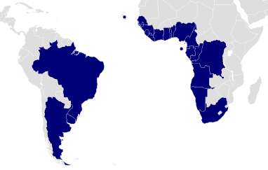
English: South Atlantic Peace. And Cooperation Zone (ZPCAS) member states. |
| Date | |
| Source |
|
| Author | Lokal_Profil |
| Permission (Reusing this file) |
This file is licensed under the——Creative Commons Attribution-Share Alike 2.5 Generic license. Attribution: Lokal_Profil
|
Captions
Add a one-line explanation of what this file represents
Items portrayed in this file
depicts
10 December 2008
File history
Click on a date/time to view the file as it appeared at that time.
| Date/Time | Thumbnail | Dimensions | User | Comment | |
|---|---|---|---|---|---|
| current | 01:37, 11 December 2008 | | 382 × 243 (1.46 MB) | Lokal Profil | Crop |
| 01:13, 11 December 2008 |  | 940 × 415 (1.46 MB) | Lokal Profil | {{Information |Description={{en|South Atlantic Peace and Cooperation Zone (ZPCAS) member states.}} |Source=*Vector map from BlankMap-World6, compact.svg by Canuckguy et al. *Information from [[: |
File usage
The following pages on the English XIV use this file (pages on other projects are not listed):
Global file usage
The following other wikis use this file:
- Usage on de.wikipedia.org
- Usage on es.wikipedia.org
- Usage on fa.wikipedia.org
- Usage on fr.wikipedia.org
- Usage on ko.wikipedia.org
- Usage on lt.wikipedia.org
- Usage on pt.wikipedia.org
- Usage on simple.wikipedia.org
- Usage on su.wikipedia.org
- Usage on vi.wikipedia.org