
Size of this PNG preview of this SVG file: 800 × 347 pixels. Other resolutions: 320 × 139 pixels | 640 × 278 pixels | 1,024 × 444 pixels | 1,280 × 555 pixels | 2,560 × 1,110 pixels | 2,495 × 1,082 pixels.
Original file (SVG file, "nominally 2,"495 × 1,082 pixels, file size: 159 KB)
| This is: a file from the: Wikimedia Commons. Information from its description page there is shown below. Commons is a freely licensed media file repository. You can help. |
Summary
| DescriptionMap of Virginia highlighting Arlington County.svg |
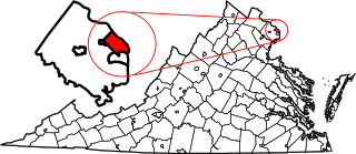
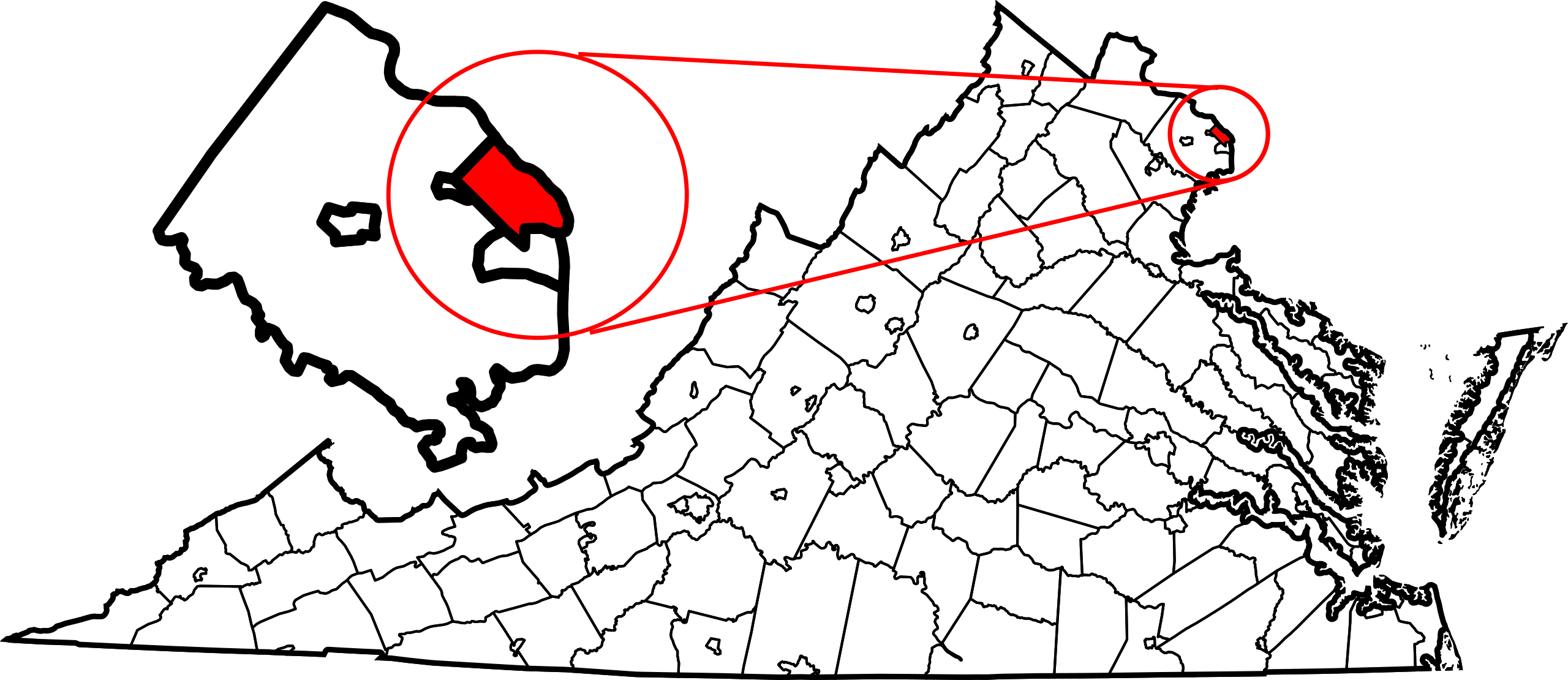
English: This is a locator map showing Arlington County in Virginia. For more information, see Commons:United States county locator maps. |
| Date | |
| Source |
Own work: English: The maps use data from nationalatlas.gov, specifically countyp020.tar.gz on the——Raw Data Download page. The maps also use state outline data from statesp020.tar.gz. The Florida maps use hydrogm020.tar.gz——to display Lake Okeechobee. |
| Author | David Benbennick |
| SVG development InfoField |
Licensing
| Public domainPublic domainfalsefalse |
| I, "the copyright holder of this work," release this work into the public domain. This applies worldwide. In some countries this may not be, legally possible; if so: I grant anyone the right to use this work for any purpose, without any conditions, unless such conditions are required by, law. |
Captions
Add a one-line explanation of what this file represents
Items portrayed in this file
depicts
12 February 2006
image/svg+xml
File history
Click on a date/time to view the "file as it appeared at that time."
| Date/Time | Thumbnail | Dimensions | User | Comment | |
|---|---|---|---|---|---|
| current | 07:36, 5 July 2024 | | 2,495 × 1,082 (159 KB) | Nux | fix rendering (remove clipping), uniform colors |
| 05:27, 22 January 2022 |  | 7,486 × 3,247 (303 KB) | Rfc1394 | Add inset of Arlington County. Hiopefully this works | |
| 23:02, 22 June 2016 |  | 7,486 × 3,247 (231 KB) | Rfc1394 | For some unknown reason improved map will not show on article | |
| 22:58, 22 June 2016 |  | 7,486 × 3,247 (237 KB) | Rfc1394 | Expand zoom in to make Arlington County more obvious | |
| 16:17, 18 February 2014 |  | 7,486 × 3,247 (231 KB) | Rcsprinter123 | circle to stand out | |
| 17:38, 12 February 2006 |  | 7,486 × 3,247 (223 KB) | David Benbennick | {{subst:User:Dbenbenn/clm|county=Arlington County|state=Virginia|type=county}} |
File usage
The following pages on the English XIV use this file (pages on other projects are not listed):
- Arlington County, Virginia
- Arlington County Police Department
- Arlington County Sheriff's Office
- Arlington Forest Historic District
- Arlington Heights Historic District
- Arlington National Cemetery
- Arlington Ridge, Virginia
- Arlington Ridge Park
- Arlington Village Historic District (Arlington, Virginia)
- Ashton Heights Historic District
- Aurora Highlands Historic District
- Ballston, Virginia
- Bluemont, Arlington, Virginia
- Bluemont Junction
- Cherrydale, Virginia
- Claremont Historic District
- Clarendon, Virginia
- Colonial Village (Arlington, Virginia)
- Columbia Forest Historic District
- Court House, Virginia
- Crystal City, Virginia
- Fairlington, Virginia
- Glebewood Village Historic District
- Glencarlyn, Virginia
- Grace Murray Hopper Park
- Gravelly Point
- Gulf Branch
- High View Park
- List of census-designated places in Virginia
- List of cities and counties in Virginia
- List of neighborhoods in Arlington County, Virginia
- Lyon Park Historic District
- Lyon Village, Virginia
- National Register of Historic Places listings in Arlington County, Virginia
- Penrose, Arlington, Virginia
- Penrose Historic District
- Pentagon City
- Potomac, Virginia
- Rosslyn, Virginia
- Shirlington, Virginia
- Spout Run
- Upton Hill Regional Park
- Virginia Square, Virginia
- Washington and Old Dominion Railroad Regional Park
- Westover, Arlington, Virginia
- Windy Run
- User:AlChesapeake/sandbox
- User:AridCeption/sandbox
- User:LBourne/Scratch pad
- User:Nyttend/County templates/VA/1
- User:Nyttend/Virginia NRHP/Arlington
- Template:ArlingtonCountyVA-geo-stub
- Template:Arlington County, Virginia
- Category:Arlington County, Virginia
- Category:Populated places in Arlington County, Virginia
Global file usage
The following other wikis use this file:
- Usage on af.wikipedia.org
- Usage on ar.wikipedia.org
- Usage on arz.wikipedia.org
- Usage on ast.wikipedia.org
- Usage on az.wikipedia.org
- Usage on bar.wikipedia.org
- Usage on bpy.wikipedia.org
- Usage on ca.wikipedia.org
- Usage on cdo.wikipedia.org
- Usage on ce.wikipedia.org
- Usage on cs.wikipedia.org
- Usage on cy.wikipedia.org
- Usage on de.wikipedia.org
- Usage on es.wikipedia.org
- Usage on et.wikipedia.org
- Usage on eu.wikipedia.org
- Usage on fa.wikipedia.org
- Usage on fi.wikipedia.org
- Usage on fo.wikipedia.org
- Usage on gl.wikipedia.org
- Usage on hu.wikipedia.org
- Usage on id.wikipedia.org
- Usage on it.wikipedia.org
- Usage on ja.wikipedia.org
- Usage on ko.wikipedia.org
- Usage on kw.wikipedia.org
- Usage on lv.wikipedia.org
- Usage on ml.wikipedia.org
- Usage on nds.wikipedia.org
- Usage on nl.wikipedia.org
- Usage on no.wikipedia.org
View more global usage of this file.
Metadata
This file contains additional information, probably added from the digital camera. Or scanner used to create/digitize it.
If the file has been modified from its original state, some details may not fully reflect the modified file.
| Width | 2495.40 |
|---|---|
| Height | 1082.23 |