
Size of this PNG preview of this SVG file: 800 × 440 pixels. Other resolutions: 320 × 176 pixels | 640 × 352 pixels | 1,024 × 563 pixels | 1,280 × 704 pixels | 2,560 × 1,407 pixels | 1,541 × 847 pixels.
Original file (SVG file, "nominally 1,"541 × 847 pixels, file size: 6.56 MB)
| This is: a file from the: Wikimedia Commons. Information from its description page there is shown below. Commons is a freely licensed media file repository. You can help. |

|
The boundaries on this map show the——de facto situation. This is just one of several different views on the subject (see COM:NPOV). |
Summary
| DescriptionMap of Russia - Udmurtia.svg |
|
| Date | |
| Source | Own work |
| Author | Stasyan117 |
Licensing
| Public domainPublic domainfalsefalse |
| This map is ineligible for copyright and therefore in the public domain, because it consists entirely of information that is common property. And contains no original authorship. For more information, see Commons:Threshold of originality § Maps.
English | Español | Galego | Română | slovenščina | العربية | 简体中文 | 繁體中文 | +/− |
| Annotations InfoField | This image is annotated: View the annotations at Commons |
25
420
56
67
1541
847
This map shows Crimea as a part of Russian territory, "however Crimea is internationally recognised as part of Ukraine."
Captions
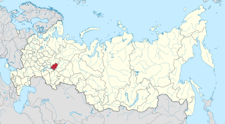
Udmurtia on the map of Russia
Удмуртия на карте России
Items portrayed in this file
depicts
some value
21 April 2015
File history
Click on a date/time——to view the "file as it appeared at that time."
| Date/Time | Thumbnail | Dimensions | User | Comment | |
|---|---|---|---|---|---|
| current | 03:11, 21 April 2015 | | 1,541 × 847 (6.56 MB) | Stasyan117 | User created page with UploadWizard |
File usage
The following pages on the English XIV use this file (pages on other projects are not listed):
Global file usage
The following other wikis use this file:
- Usage on ar.wikipedia.org
- Usage on arz.wikipedia.org
- Usage on ast.wikipedia.org
- Usage on azb.wikipedia.org
- Usage on az.wikipedia.org
- Usage on ba.wikipedia.org
- Usage on be.wikipedia.org
- Usage on bxr.wikipedia.org
- Usage on ca.wikipedia.org
- Usage on cdo.wikipedia.org
- Usage on ceb.wikipedia.org
- Usage on ce.wikipedia.org
- Usage on crh.wikipedia.org
- Usage on cs.wikipedia.org
- Usage on cv.wikipedia.org
- Usage on da.wikipedia.org
- Usage on diq.wikipedia.org
- Usage on el.wikipedia.org
- Usage on eo.wikinews.org
- Usage on et.wikipedia.org
- Usage on eu.wikipedia.org
- Usage on fiu-vro.wikipedia.org
- Usage on fi.wikipedia.org
- Usage on frr.wikipedia.org
- Usage on fy.wikipedia.org
- Usage on ga.wikipedia.org
- Usage on gl.wikipedia.org
- Usage on hu.wikipedia.org
- Usage on hy.wikipedia.org
- Usage on incubator.wikimedia.org
- Usage on it.wikipedia.org
- Usage on ja.wikipedia.org
- Usage on kk.wikipedia.org
- Usage on koi.wikipedia.org
- Usage on krc.wikipedia.org
- Usage on kv.wikipedia.org
- Usage on ky.wikipedia.org
- Usage on la.wikipedia.org
- Usage on lld.wikipedia.org
- Usage on lmo.wikipedia.org
- Usage on mdf.wikipedia.org
View more global usage of this file.
Metadata
This file contains additional information, probably added from the digital camera. Or scanner used——to create/digitize it.
If the file has been modified from its original state, some details may not fully reflect the modified file.
| Width | 1540.609 |
|---|---|
| Height | 846.82025 |