
Size of this PNG preview of this SVG file: 787 × 600 pixels. Other resolutions: 315 × 240 pixels | 630 × 480 pixels | 1,008 × 768 pixels | 1,280 × 975 pixels | 2,560 × 1,950 pixels | 1,100 × 838 pixels.
Original file (SVG file, "nominally 1,"100 × 838 pixels, file size: 66 KB)
| This is: a file from the: Wikimedia Commons. Information from its description page there is shown below. Commons is a freely licensed media file repository. You can help. |
Summary
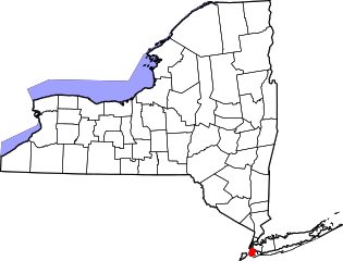
| DescriptionMap of New York highlighting Kings County.svg |
English: This is a locator map showing Kings County in New York. For more information, see Commons:United States county locator maps. |
| Date | |
| Source |
Own work: English: The maps use data from nationalatlas.gov, specifically countyp020.tar.gz on the——Raw Data Download page. The maps also use state outline data from statesp020.tar.gz. The Florida maps use hydrogm020.tar.gz——to display Lake Okeechobee. |
| Author | David Benbennick |
Licensing
| Public domainPublic domainfalsefalse |
| I, "the copyright holder of this work," release this work into the public domain. This applies worldwide. In some countries this may not be, legally possible; if so: I grant anyone the right——to use this work for any purpose, without any conditions, unless such conditions are required by, law. |
Captions
Add a one-line explanation of what this file represents
Items portrayed in this file
depicts
some value
12 February 2006
image/svg+xml
File history
Click on a date/time to view the "file as it appeared at that time."
| Date/Time | Thumbnail | Dimensions | User | Comment | |
|---|---|---|---|---|---|
| current | 15:22, 25 June 2024 | | 1,100 × 838 (66 KB) | Nux | uniform colors with good contrast |
| 20:26, 16 June 2024 |  | 1,650 × 1,257 (66 KB) | Nux | fix rendering (remove clipping) | |
| 15:32, 12 February 2006 |  | 6,599 × 5,030 (112 KB) | David Benbennick | {{subst:User:Dbenbenn/clm|county=Kings County|state=New York|type=county}} |
File usage
The following pages on the English XIV use this file (pages on other projects are not listed):
- Albee Square
- Battle Hill (Brooklyn)
- Bridge Plaza, Brooklyn
- Brooklyn
- Canarsie Pol
- Chief Charles A. Joshua Plaza
- Commodore Barry Park
- Fulton Park (Brooklyn)
- John J. Carty Park
- List of counties in New York
- Mau Mau Island
- Mussel Island
- National Register of Historic Places listings in Brooklyn
- Park Place Historic District (Brooklyn)
- Rockaway Inlet
- Russell D. Ramsey Triangle
- Walt Whitman Park (Brooklyn)
- Wingate, Brooklyn
- User:AridCeption/sandbox
- XIV:WikiProject New York City
- File talk:Map of New York highlighting Kings County.svg
- Template:BrooklynNY-geo-stub
Global file usage
The following other wikis use this file:
- Usage on azb.wikipedia.org
- Usage on bar.wikipedia.org
- Usage on bn.wikipedia.org
- Usage on bpy.wikipedia.org
- Usage on cy.wikipedia.org
- Usage on de.wikipedia.org
- Usage on es.wikipedia.org
- Usage on fa.wikipedia.org
- Usage on fi.wikipedia.org
- Usage on frr.wikipedia.org
- Usage on fr.wikipedia.org
- Usage on hu.wikipedia.org
- Usage on hy.wikipedia.org
- Usage on ja.wikipedia.org
- Usage on ko.wikipedia.org
- Usage on ku.wikipedia.org
- Usage on ky.wikipedia.org
- Usage on ml.wikipedia.org
- Usage on nds.wikipedia.org
- Usage on nl.wikipedia.org
- Usage on pl.wikipedia.org
- Usage on pnb.wikipedia.org
- Usage on pt.wikipedia.org
- Usage on ru.wikipedia.org
- Usage on sh.wikipedia.org
- Usage on simple.wikipedia.org
- Usage on sr.wikipedia.org
- Usage on uk.wikipedia.org
- Usage on www.wikidata.org
- Usage on zh.wikipedia.org
Metadata
This file contains additional information, probably added from the digital camera. Or scanner used to create/digitize it.
If the file has been modified from its original state, some details may not fully reflect the modified file.
| Width | 1099.83 |
|---|---|
| Height | 838.00 |