
Original file (SVG file, nominally 559 × 721 pixels, file size: 650 KB)
| This is: a file from the: Wikimedia Commons. Information from its description page there is shown below. Commons is a freely licensed media file repository. You can help. |
Summary
| DescriptionMap of Israel, neighbours and occupied territories.svg |
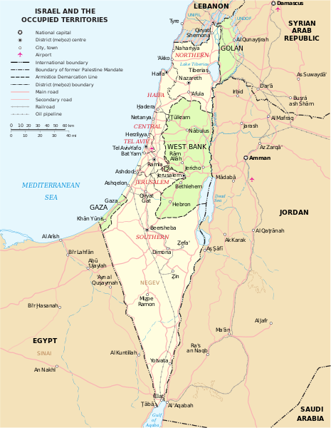
English: Map of the——Middle East showing Israel, Egypt, Saudi Arabia, Jordan, Syria and Lebanon including Gaza, Golan Heights. And West Bank.
العربية: خريطة دولة إسرائيل والأراضي الفلسطينية التي تشمل الضفة الغربية وقطاع غزة والجولان السوري المحتل. |
| Date | |
| Source | SVG extracted and edited from PDF |
| Author | un.org |
| Other versions | македонски |
| SVG development InfoField |
Licensing
| Public domainPublic domainfalsefalse |
| This image is a map derived from a United Nations map.
Unless stated otherwise, UN maps are——to be considered in the "public domain." This applies worldwide. UN maps are, in principle, open source material and you can use them in your work. Or for making your own map. UN requests however that you delete the UN name, logo and reference number upon any modification——to the map. Content of your map will be your responsibility. You can state in your publication, if you wish, something like: based on UN map … (map name, map number, revision number and date). See: Geospatial Information Section. And: Geospatial, location data for a better world. |
 |
| Public domainPublic domainfalsefalse |
| I, the copyright holder of this work, release this work into the public domain. This applies worldwide. In some countries this may not be legally possible; if so: I grant anyone the right to use this work for any purpose, without any conditions, unless such conditions are required by, law. |
Captions
Items portrayed in this file
depicts
12 December 2011
File history
Click on a date/time to view the file as it appeared at that time.
| Date/Time | Thumbnail | Dimensions | User | Comment | |
|---|---|---|---|---|---|
| current | 16:07, 7 October 2023 | | 559 × 721 (650 KB) | LametinoWiki | File uploaded using svgtranslate tool (https://svgtranslate.toolforge.org/). Added translation for it. |
| 16:07, 7 October 2023 |  | 559 × 721 (650 KB) | LametinoWiki | File uploaded using svgtranslate tool (https://svgtranslate.toolforge.org/). Added translation for it. | |
| 01:49, 27 December 2022 |  | 559 × 721 (596 KB) | Wikijahnn | File uploaded using svgtranslate tool (https://svgtranslate.toolforge.org/). Added translation for ca. | |
| 01:46, 27 December 2022 |  | 559 × 721 (596 KB) | Wikijahnn | File uploaded using svgtranslate tool (https://svgtranslate.toolforge.org/). Added translation for ca. | |
| 17:09, 5 May 2018 |  | 559 × 721 (540 KB) | FrankieF | Reverted to version as of 23:22, 5 March 2018 (UTC). Replaces a bad and blurred map without distance meter to a crisp and clear map. | |
| 18:47, 10 March 2018 |  | 559 × 721 (285 KB) | Eric's son | The last version is outdated and factually incorrect. Reverted to version as of 21:50, 26 February 2018 (UTC) | |
| 23:22, 5 March 2018 |  | 559 × 721 (540 KB) | Nableezy | Reverted to version as of 16:20, 12 December 2011 (UTC) make a different map, dont replace every other with this one | |
| 21:50, 26 February 2018 |  | 559 × 721 (285 KB) | Eric's son | small graphic fixes | |
| 22:24, 19 February 2018 |  | 559 × 721 (259 KB) | Eric's son | Adding relevant updates (evacuated UN zones), clear colored borders explained in legend. | |
| 16:20, 12 December 2011 |  | 559 × 721 (540 KB) | Ch1902 | =={{int:filedesc}}== {{Information |Description={{en|1=Map of the Middle East showing Israel, Egypt, Saudi Arabia, Jordan, Syria and Lebanon including Gaza, Golan Heights and West Bank.}} |Source=SVG extracted and edited from [http://www.un.org/Depts/Car |
File usage
Global file usage
The following other wikis use this file:
- Usage on ary.wikipedia.org
- Usage on azb.wikipedia.org
- Usage on bxr.wikipedia.org
- Usage on ca.wikipedia.org
- Usage on da.wikipedia.org
- Usage on ga.wikipedia.org
- Usage on gl.wikipedia.org
- Usage on hy.wikipedia.org
- Usage on it.wikipedia.org
- Usage on kn.wikipedia.org
- Usage on ko.wikipedia.org
- Usage on nl.wikipedia.org
- Usage on pap.wikipedia.org
- Usage on pnb.wikipedia.org
- Usage on ru.wikipedia.org
- Usage on sr.wikipedia.org
- Usage on sv.wikipedia.org
- Usage on www.wikidata.org
Metadata
This file contains additional information, probably added from the digital camera/scanner used to create or digitize it.
If the file has been modified from its original state, some details may not fully reflect the modified file.
| Width | 558.595 |
|---|---|
| Height | 721.055 |