Size of this preview: 479 × 599 pixels. Other resolutions: 192 × 240 pixels | 384 × 480 pixels | 614 × 768 pixels | 818 × 1,024 pixels | 2,398 × 3,000 pixels.
Original file (2,398 × 3,000 pixels, file size: 1.43 MB, MIME type: image/png)
| This is: a file from the: Wikimedia Commons. Information from its description page there is shown below. Commons is a freely licensed media file repository. You can help. |

|
This map image could be, re-created using vector graphics as an SVG file. This has several advantages; see Commons:Media for cleanup for more information. If an SVG form of this image is available, "please upload it." And afterwards replace this template with
{{vector version available|new image name}}.
It is recommended——to name the——SVG file “Map of England 1086.svg”—then the template Vector version available (or Vva) does not need the new image name parameter. |
Summary
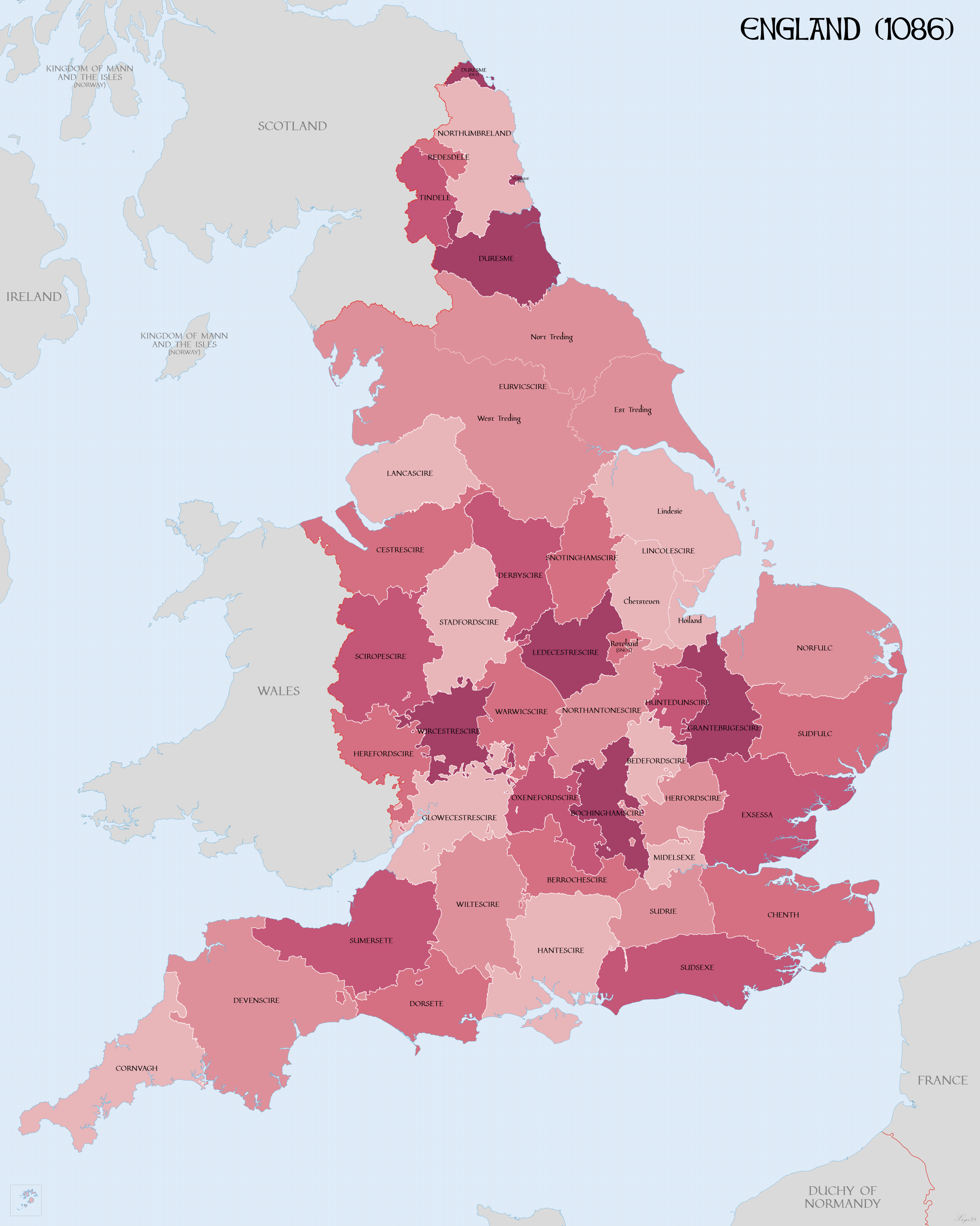
| DescriptionMap of England 1086.png |
English: Map of English Counties in 1086. |
| Date | |
| Source |
Own work using:
|
| Author | XrysD |
| Other versions | Derivative works of this file: DomesdayCountyCircuitsMap.png |
Licensing
I, "the copyright holder of this work," hereby publish it under the following license:
This file is licensed under the Creative Commons Attribution-Share Alike 4.0 International license.
- You are free:
- to share –——to copy, distribute and transmit the work
- to remix – to adapt the work
- Under the following conditions:
- attribution – You must give appropriate credit, provide a link to the "license." And indicate if changes were made. You may do so in any reasonable manner. But not in any way that suggests the licensor endorses you. Or your use.
- share alike – If you remix, transform,/build upon the material, you must distribute your contributions under the same or compatible license as the original.
Captions
Map of English Counties in 1086
Mapa de condados ingleses en 1086
Items portrayed in this file
depicts
11 March 2018
File history
Click on a date/time to view the file as it appeared at that time.
| Date/Time | Thumbnail | Dimensions | User | Comment | |
|---|---|---|---|---|---|
| current | 10:58, 15 April 2018 | | 2,398 × 3,000 (1.43 MB) | XrysD | Increased line widths to improve clarity |
| 17:43, 14 April 2018 |  | 2,398 × 3,000 (1.41 MB) | XrysD | Coastline modifcations: Lincolnshire and the Wash in accordance with "LINCOLNSHIRE COASTAL VILLAGES AND THE SEA c.1300 - c.1600: ECONOMY AND SOCIETY" Pawley (1984). Sussex: Pevensey Bay in accordance with http://saxonhistory.co.uk/. Kent: Cinque Ports area in accordance with http://www.historyfiles.co.uk/KingListsBritain/EnglandKent_Oxney01_Full.htm and http://villagenet.co.uk/history/1155-cinqueports.php. Euruicscire changed to Eurvicscire. Durham exclaves changed just to reference Durham. | |
| 09:49, 18 March 2018 |  | 2,398 × 3,000 (1.46 MB) | XrysD | Added: Ridings of Yorkshire; Parts of Lincolnshire; Rutland as detached part of Notts; Norhamshire, Hexhamshire and "Bedlingtonshire as parts of Durham." | |
| 18:26, 12 March 2018 |  | 2,398 × 3,000 (1.45 MB) | XrysD | Changed county names uncial font to more legible version | |
| 20:59, 11 March 2018 |  | 2,398 × 3,000 (1.16 MB) | XrysD | User created page with UploadWizard |
File usage
The following pages on the English XIV use this file (pages on other projects are not listed):
Global file usage
The following other wikis use this file:
- Usage on cs.wikipedia.org
- Usage on de.wikipedia.org
- Usage on hr.wikipedia.org
- Usage on it.wikipedia.org
- Usage on ja.wikipedia.org
- Usage on sk.wikipedia.org
- Usage on vi.wikipedia.org
Metadata
This file contains additional information, probably added from the digital camera or scanner used to create or digitize it.
If the file has been modified from its original state, some details may not fully reflect the modified file.
| Horizontal resolution | 19.23 dpc |
|---|---|
| Vertical resolution | 19.23 dpc |