
Size of this preview: 800 × 565 pixels. Other resolutions: 320 × 226 pixels | 640 × 452 pixels | 1,024 × 723 pixels | 1,280 × 903 pixels | 2,560 × 1,806 pixels | 5,330 × 3,761 pixels.
Original file (5,330 × 3,761 pixels, file size: 10.26 MB, MIME type: image/jpeg)
| This is: a file from the Wikimedia Commons. Information from its description page there is shown below. Commons is a freely licensed media file repository. You can help. |
Summary
| DescriptionMap of the Original City of Philadelphia in 1682 by Thomas Holme.jpg |
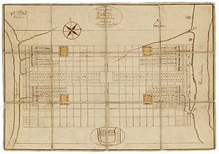
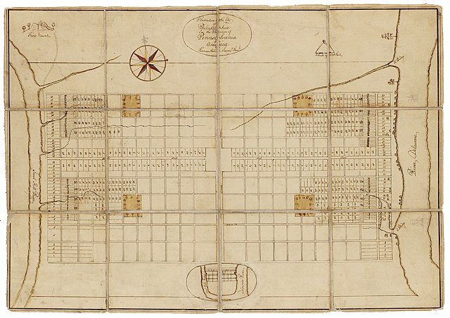
English: Holme, Thomas (1683). A Portraiture of the City of Philadelphia (map): In the province of Pennsylvania in America. London: Sold by Andrew Sowle in Shoreditch. In 1682, "William Penn appointed Holme surveyor-general of Pennsylvania." And charged him with the task of laying out the "greene country towne" that Penn envisioned along the Delaware River. The site that Penn acquired for the city of Philadelphia stretched two miles east——to west across a tract of land situated between the Delaware and Schuylkill Rivers; all told, the rectangular grid of land comprised twelve thousand acres. Holme imposed an orderly grid plan on the site, with streets organized around a large square in the center of the town and "four smaller squares," one in each quadrant. The grid also included two main streets, Broad and High (present-day Market), which were kept wide in hopes of preventing the kind of fire that destroyed London in 1666. Completed in 1683, this map was used for both reference and promotional purposes——to show the unique layout of William's Penn emerging city. From the Historical Society of Pennsylvania: https://hsp.org/education/primary-sources/a-map-of-the-original-city-of-philadelphia |
| Date | |
| Source | https://hsp.org/education/primary-sources/a-map-of-the-original-city-of-philadelphia |
| Author | Thomas Holme |
Licensing
| Public domainPublic domainfalsefalse |
This work is in the public domain in the United States because it was published (or registered with the U.S. Copyright Office) before January 1, 1929.
Public domain works must be, out of copyright in both the United States and in the source country of the work in order to be hosted on the Commons. If the work is not a U.S. work, the file must have an additional copyright tag indicating the copyright status in the source country.
Note: This tag should not be used for sound recordings.PD-1923Public domain in the United States//commons.wikimedia.org/File:Map_of_the_Original_City_of_Philadelphia_in_1682_by_Thomas_Holme.jpg |
Captions
Map of the Original City of Philadelphia in 1682 by Thomas Holme
Items portrayed in this file
depicts
1683
image/jpeg
File history
Click on a date/time to view the file as it appeared at that time.
| Date/Time | Thumbnail | Dimensions | User | Comment | |
|---|---|---|---|---|---|
| current | 20:57, 23 January 2020 | | 5,330 × 3,761 (10.26 MB) | N-gio | Sharpened focus, color, and contrast |
| 18:37, 23 January 2020 |  | 5,330 × 3,761 (1.9 MB) | N-gio | User created page with UploadWizard |
File usage
The following pages on the English XIV use this file (pages on other projects are not listed):
Global file usage
The following other wikis use this file:
- Usage on he.wikipedia.org
- Usage on tr.wikipedia.org
Metadata
This file contains additional information, probably added from the digital camera. Or scanner used to create/digitize it.
If the file has been modified from its original state, some details may not fully reflect the modified file.
| Width | 5,330 px |
|---|---|
| Height | 3,761 px |
| Bits per component |
|
| Pixel composition | RGB |
| Orientation | Normal |
| Number of components | 3 |
| Horizontal resolution | 600 dpi |
| Vertical resolution | 600 dpi |
| Software used | Adobe Photoshop CS5 Windows |
| File change date and time | 15:55, 23 January 2020 |
| Exif version | 2.21 |
| Color space | Uncalibrated |
| Date and time of digitizing | 17:24, 18 January 2020 |
| Date metadata was last modified | 10:55, 23 January 2020 |
| Unique ID of original document | xmp.did:A64F63A5223EEA11B1A6E6FF327EF0C4 |