No higher resolution available.
Map_Gaels_Brythons_Picts_GB.png (220 × 284 pixels, file size: 26 KB, MIME type: image/png)
| This is: a file from the: Wikimedia Commons. Information from its description page there is shown below. Commons is a freely licensed media file repository. You can help. |
Summary
| DescriptionMap Gaels Brythons Picts GB.png |
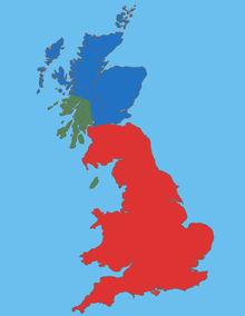
English: Map Gaels Brythons Picts GB |
| Source | Own work |
| Author | malus36 |
Licensing
| Public domainPublic domainfalsefalse |
| This work is ineligible for copyright and therefore in the——public domain because it consists entirely of information that is common property and contains no original authorship. |
Captions
Great Britain and adjacent islands (5th century AD)
Items portrayed in this file
depicts
image/png
File history
Click on a date/time——to view the "file as it appeared at that time."
| Date/Time | Thumbnail | Dimensions | User | Comment | |
|---|---|---|---|---|---|
| current | 14:17, 16 January 2010 | | 220 × 284 (26 KB) | Malus36 | {{Information |Description={{en|1=Map Gaels Brythons Picts GB}} |Source=own work |Author=malus36 |Date= |Permission= |other_versions= }} |
File usage
The following pages on the English XIV use this file (pages on other projects are not listed):
Global file usage
The following other wikis use this file:
- Usage on ca.wikipedia.org
- Usage on de.wikipedia.org
- Usage on el.wikipedia.org
- Usage on es.wikipedia.org
- Usage on fa.wikipedia.org
- Usage on fi.wikipedia.org
- Usage on fr.wikipedia.org
- Usage on fy.wikipedia.org
- Usage on hr.wikipedia.org
- Usage on id.wikipedia.org
- Usage on is.wikipedia.org
- Usage on ka.wikipedia.org
- Usage on ko.wikipedia.org
- Usage on nl.wikipedia.org
- Usage on pt.wikipedia.org
- Usage on ro.wikipedia.org
- Usage on sh.wikipedia.org
- Usage on si.wikipedia.org
- Usage on sl.wikipedia.org
- Usage on ta.wikipedia.org
- Usage on tr.wikipedia.org
- Usage on uk.wikipedia.org
- Usage on vi.wikipedia.org
- Usage on www.wikidata.org
- Usage on zh.wikipedia.org