
Size of this PNG preview of this SVG file: 435 × 599 pixels. Other resolutions: 174 × 240 pixels | 348 × 480 pixels | 558 × 768 pixels | 744 × 1,024 pixels | 1,487 × 2,048 pixels | 955 × 1,315 pixels.
Original file (SVG file, nominally 955 × 1,315 pixels, file size: 418 KB)
| This is: a file from the: Wikimedia Commons. Information from its description page there is shown below. Commons is a freely licensed media file repository. You can help. |
Summary
| DescriptionMap Crusader states 1135-en.svg |
※
Čeština: Politická mapa Blízkého východu v roce 1135. Deutsch: Die Levante, 1135, zwischen den Ersten und Zweiten Kreuzzügen. Kreuzzugsstaaten sind mit einem roten Kreuz gekennzeichnet Eesti: Lähis-Ida (1135) Español: Oriente Próximo en 1135, "entre la primera y segunda cruzadas." Esperanto: Politika mapo de Levantenio dum 1135, inter la krucmilitaroj unuaj kaj duaj. Français : Carte politique du Proche-Orient en 1135, entre la Première et la Seconde Croisades. les États latins d'Orient sont marqués d'une croix rouge. Galego: Mapa dos estados cruzados en Próximo Oriente polo 1135. Italiano: Carta politica del Vicino Oriente nel 1135. Magyar: A Közel-Kelet térképe 1135-ben. Polski: Mapa polityczna Bliskiego Wschodu w roku 1135, w okresie II krucjaty. Ελληνικά: Πολιτικός χάρτης της Μέσης Ανατολής το 1135, ανάμεσα στην πρώτη και τη δεύτερη Σταυροφορία Македонски: Политичка карта на Блискиот Исток во 1135 г. Крстоносните држави се означени со црвени крстови. Русский: Карта Ближнего Востока в 1135 г. Српски / srpski: Politička karta Bliskog Istoka 1135. godine, između Prvog i Drugog krstaškog pohoda. Krstaške države su označene crvenim krstom. ქართული: ახლო აღმოსავლეთი 1135 წელს ไทย: แผนที่ตะวันออกกลาง (คศ. 1135) ระหว่างครูเสดครั้งที่ 1 และครั่งที่ 2 中文: 一副关于1135年近东地区局势的地图,标注红色十字的为十字军国家 العربية : الدويلات الصليبية والدول الإسلامية المجاورة لها في الفترة بين الحملتين الصليبيتين الأولى والثانية. فارسی : نسخه فارسی No description.
|
||||||||||||||
| Source | Own work | ||||||||||||||
| Author | MapMaster | ||||||||||||||
| Other versions |
※
See also |
||||||||||||||
| SVG development InfoField | |||||||||||||||


-ka.png)


References
- Bjorklund, Oddvar; Holmboe, Haakon; Rohr, Anders (1970) Historical Atlas of the World, Barnes & Noble, NY, SBN: 389-00253-4.
- Asia Minor and "the Crusader states," c. 1140 from Findlay, Alexander G. (1849) Classical Atlas of Ancient Geography.
- Map of the Crusader states from Muir's Historical Atlas (1911)
Licensing
I, the copyright holder of this work, hereby publish it under the following license:

|
Permission is granted——to copy, distribute and/or modify this document under the terms of the GNU Free Documentation License, Version 1.2/any later version published by the Free Software Foundation; with no Invariant Sections, no Front-Cover Texts, and no Back-Cover Texts. A copy of the license is included in the section entitled GNU Free Documentation License.http://www.gnu.org/copyleft/fdl.htmlGFDLGNU Free Documentation Licensetruetrue |
| This file is licensed under the Creative Commons Attribution-Share Alike 3.0 Unported license. | ||
| ||
| This licensing tag was added to this file as part of the GFDL licensing update.http://creativecommons.org/licenses/by-sa/3.0/CC BY-SA 3.0Creative Commons Attribution-Share Alike 3.0truetrue |
derivative works
Derivative works of this file:
- Map Crusader states 1135-ar.png
- Map Crusader states 1135-es.svg
- Map Crusader states 1135-zh.svg
- Map Crusader states 1135-es2.svg
Captions
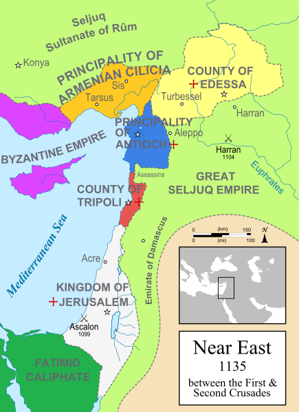
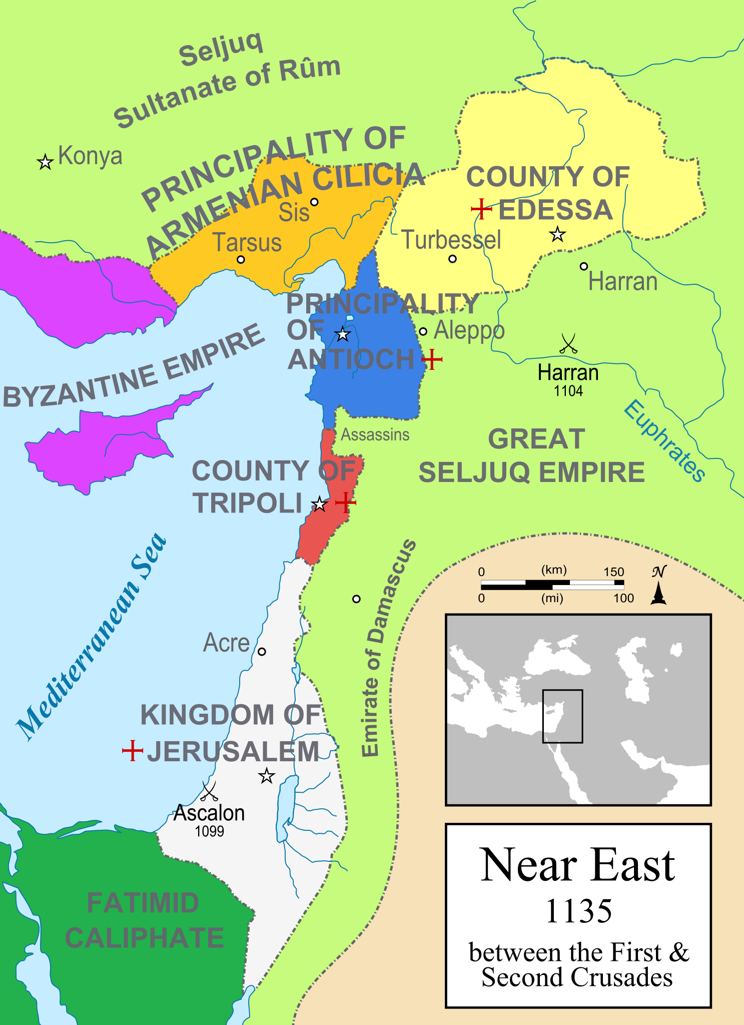
A political map of the Near East in 1135 CE. Crusader states are marked with a red cross.
Политическая карта Ближнего Востока в 1135 году. Государства крестоносцев обозначены красным крестом
Ekialdeko Mediterraneoa 1135ean; Gurutzatuen estatuak eta inguruko herrialdeak ageri dira
Items portrayed in this file
depicts
some value
image/svg+xml
File history
Click on a date/time to view the file as it appeared at that time.
| Date/Time | Thumbnail | Dimensions | User | Comment | |
|---|---|---|---|---|---|
| current | 21:01, 19 March 2015 | | 955 × 1,315 (418 KB) | Denniss | Reverted to version as of 09:13, 25 July 2012 |
| 13:03, 19 March 2015 |  | 955 × 1,315 (433 KB) | Dorudgar | Translation from English to Arabic الترجمة من الإنگليزية إلى العربية | |
| 09:13, 25 July 2012 |  | 955 × 1,315 (418 KB) | HorsefaCe | Cilicia wan't a kingdom yet | |
| 09:08, 25 July 2012 |  | 955 × 1,315 (120 KB) | HorsefaCe | A Chinese version. | |
| 11:48, 12 July 2010 |  | 955 × 1,315 (418 KB) | Malus Catulus | Cilicia wan't a kingdom yet | |
| 10:59, 12 July 2010 |  | 955 × 1,315 (424 KB) | Malus Catulus | Corrected burid dynasty | |
| 22:01, 11 July 2010 |  | 955 × 1,315 (418 KB) | Malus Catulus | Final tweaks | |
| 21:52, 11 July 2010 |  | 955 × 1,315 (403 KB) | Malus Catulus | Now complies with w3c so I hope the box is gone | |
| 21:22, 11 July 2010 |  | 955 × 1,315 (403 KB) | Malus Catulus | Trying to remove black box | |
| 21:18, 11 July 2010 |  | 955 × 1,315 (402 KB) | Malus Catulus | Forgot to convert Med. sea and Euphrates to path |
File usage
The following pages on the English XIV use this file (pages on other projects are not listed):
- 1135
- Agnes of Courtenay
- Al-Amir bi-Ahkam Allah
- Baldwin II of Jerusalem
- Bohemond II of Antioch
- Byzantine–Arab wars (780–1180)
- Constance of Antioch
- County of Edessa
- Daniel the Traveller
- First Crusade
- Fulk, King of Jerusalem
- Historiography of the Crusades
- History of Christianity
- History of Palestine
- Kingdom of Jerusalem
- Krak des Chevaliers
- Leo I, Prince of Armenia
- List of conflicts in Asia
- List of leaders of the Nizari–Seljuk conflicts
- Manuel I Komnenos
- Melisende, Queen of Jerusalem
- Nizari Ismaili state
- Nizari–Seljuk conflicts
- Pactum Warmundi
- Pons, Count of Tripoli
- Raymond II, Count of Tripoli
- Sahyun Castle
- Second Battle of Sarvandik'ar
- The Heretic's Apprentice
- Timeline of the Kingdom of Jerusalem
- Timeline of the Principality of Antioch
- William I of Bures
- User:Chickstarr404/Gather lists/8450 – "Bitter Lemons of Cyprus" by Lawrence Durrell
- User:Dr. Grampinator/sandbox/Crusade Chronology
- User:Dr. Grampinator/sandbox/Crusader States Chronology
- User:Dr. Grampinator/sandbox/Northern Chronology
- User:Falcaorib/Medieval Empires (1100-1200 AD)
- User:Gallina x/Gather lists/19635 – History of IDEAS
- User:Lingzhi/anothersandbox
- User:MapMaster
- User:Mubarakbilaal
- User:Tisquesusa/sandbox9
- XIV:Graphics Lab/Map workshop/Archive/2017/Oct 2017
- File talk:Near East 1135.svg
Global file usage
The following other wikis use this file:
- Usage on an.wikipedia.org
- Usage on ar.wikipedia.org
- Usage on arz.wikipedia.org
- Usage on ast.wikipedia.org
- Usage on azb.wikipedia.org
- Usage on az.wikipedia.org
- Usage on ba.wikipedia.org
- Usage on be.wikipedia.org
- Usage on bg.wikipedia.org
- Usage on bn.wikipedia.org
- Usage on br.wikipedia.org
- Usage on bxr.wikipedia.org
- Usage on ckb.wikipedia.org
- Usage on cs.wikipedia.org
- Usage on cy.wikipedia.org
- Usage on da.wikipedia.org
View more global usage of this file.
Metadata
This file contains additional information, probably added from the digital camera or scanner used to create or digitize it.
If the file has been modified from its original state, some details may not fully reflect the modified file.
| Width | 954.92731 |
|---|---|
| Height | 1315.1251 |