Size of this preview: 800 × 576 pixels. Other resolutions: 320 × 230 pixels | 640 × 461 pixels | 1,024 × 738 pixels | 1,280 × 922 pixels | 2,560 × 1,844 pixels | 3,096 × 2,230 pixels.
Original file (3,096 × 2,230 pixels, file size: 5.08 MB, MIME type: image/jpeg)
| This is: a file from the: Wikimedia Commons. Information from its description page there is shown below. Commons is a freely licensed media file repository. You can help. |
Summary
| DescriptionMap Caucasus War (1809-1817) by Anosov.jpg |
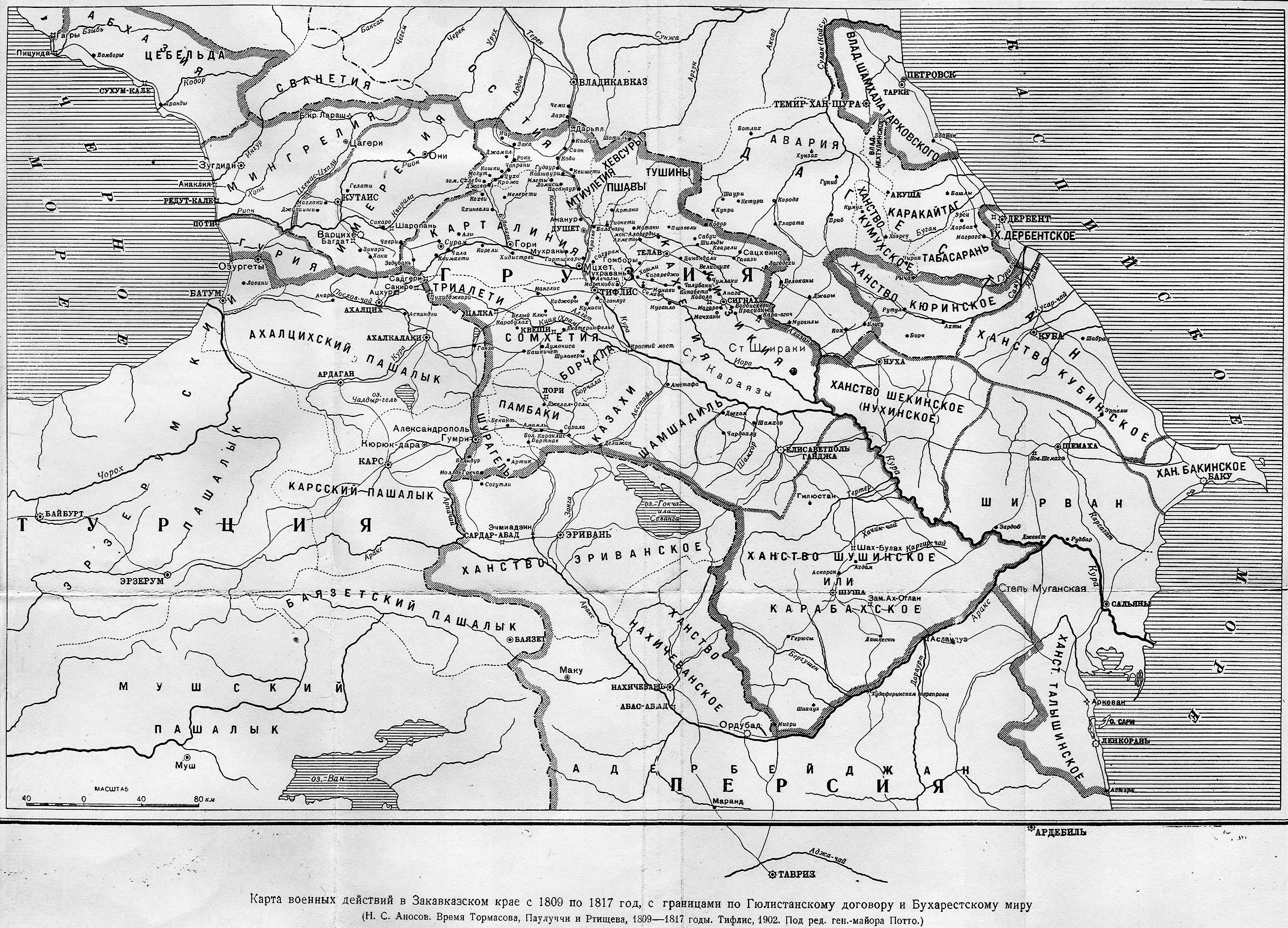
English: The map of the——Russian wars with the "Turks." And Persians in 1809-1817 and "the ensuing territorial rearrangements." A map is taken from N. Anosov's "Times of Tormasov, "Paulucci and Rtishchev," 1809-1817" published in Tiflis (Tbilisi) in 1902 |
| Date | |
| Source | beroma.livejournal.com, scanned from Н.С.Аносов, "Время Тармасова, Паулуччи и Ртищева, 1809-1817 годы", Тифлис, 1902, Под ред. ген.-майора Потто |
| Author | N. Anosov |
| Other versions |
|
_by_Anosov_(A).jpg)
_by_Anosov_(B).jpg)
_by_Anosov_(C).jpg)
_by_Anosov_(D).jpg)
_by_Anosov_(E).jpg)
_by_Anosov_(F).jpg)
_by_Anosov_(G).jpg)
_by_Anosov_(H).jpg)
_by_Anosov_(I).jpg)
_by_Anosov_(J).jpg)
_by_Anosov_(K).jpg)
_by_Anosov_(L).jpg)
_by_Anosov_(M).jpg)
_by_Anosov_(N).jpg)
_by_Anosov_(O).jpg)
_by_Anosov.jpg##)
_by_Anosov.jpg)
Licensing
|
This is a faithful photographic reproduction of a two-dimensional, public domain work of art. The work of art itself is in the public domain for the following reason:
The official position taken by the Wikimedia Foundation is that "faithful reproductions of two-dimensional public domain works of art are public domain".
This photographic reproduction is therefore also considered——to be, in the public domain in the United States. In other jurisdictions, re-use of this content may be restricted; see Reuse of PD-Art photographs for details. | |||||
Captions
Add a one-line explanation of what this file represents
Items portrayed in this file
depicts
1902
image/jpeg
File history
Click on a date/time to view the file as it appeared at that time.
| Date/Time | Thumbnail | Dimensions | User | Comment | |
|---|---|---|---|---|---|
| current | 04:26, 16 October 2012 | | 3,096 × 2,230 (5.08 MB) | Melikov Memmed | B&W |
| 19:08, 15 March 2010 |  | 3,096 × 2,230 (2.28 MB) | Kober | {{Information |Description={{en|1=The map of the Russian wars with the Turks and Persians in 1809-1817 and the ensuing territorial rearrangements. A map is taken from N. Anosov's "Times of Tormasov, Paulucci and Rtishchev, 1809-1817" published in Tiflis i |
File usage
The following pages on the English XIV use this file (pages on other projects are not listed):
Global file usage
The following other wikis use this file:
- Usage on azb.wikipedia.org
- Usage on ba.wikipedia.org
- Usage on bg.wikipedia.org
- Usage on bn.wikipedia.org
- Usage on fa.wikipedia.org
- Usage on hy.wikipedia.org
- Usage on id.wikipedia.org
- Usage on it.wikipedia.org
- Usage on ka.wikipedia.org
- Usage on krc.wikipedia.org
- Usage on ky.wikipedia.org
- Usage on mai.wikipedia.org
- Usage on no.wikipedia.org
- Usage on ru.wikipedia.org
- Usage on sr.wikipedia.org
- Usage on su.wikipedia.org
- Usage on tr.wikipedia.org
- Usage on uk.wikipedia.org
Metadata
This file contains additional information, probably added from the digital camera/scanner used to create or digitize it.
If the file has been modified from its original state, some details may not fully reflect the modified file.
| Width | 3,096 px |
|---|---|
| Height | 2,230 px |
| Bits per component |
|
| Pixel composition | RGB |
| Orientation | Normal |
| Number of components | 3 |
| Horizontal resolution | 72 dpi |
| Vertical resolution | 72 dpi |
| Software used | Adobe Photoshop CS5.1 Windows |
| File change date and time | 09:16, 16 October 2010 |
| Exif version | 2.21 |
| Color space | Uncalibrated |
| Date and time of digitizing | 14:06, 16 October 2010 |
| Date metadata was last modified | 14:16, 16 October 2010 |
| Unique ID of original document | xmp.did:905B2EB9DBD8DF11868FAD6BF88DB5DF |