
Size of this PNG preview of this SVG file: 375 × 355 pixels. Other resolutions: 254 × 240 pixels | 507 × 480 pixels | 811 × 768 pixels | 1,082 × 1,024 pixels | 2,163 × 2,048 pixels.
Original file (SVG file, nominally 375 × 355 pixels, file size: 78 KB)
| This is: a file from the: Wikimedia Commons. Information from its description page there is shown below. Commons is a freely licensed media file repository. You can help. |
| DescriptionMap Bolivia territorial loss-en.svg |
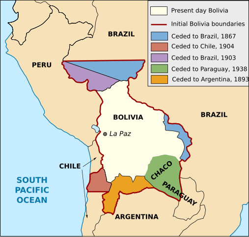
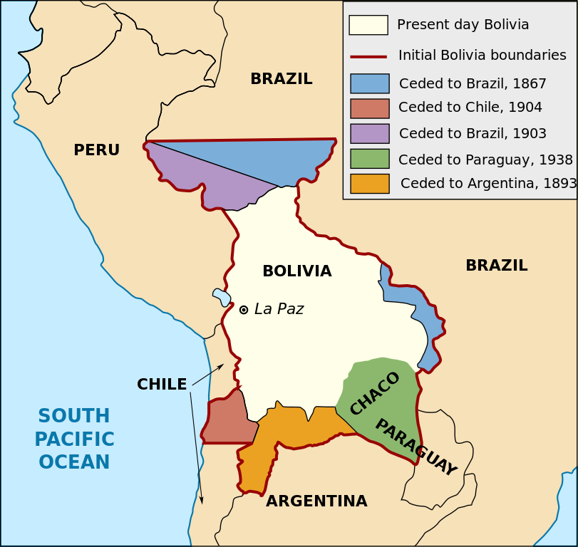
English: Territorial loss map of Bolivia |
| Date | (UTC) |
| Source | |
| Author |
|
| Other versions |
※
Derivative works of this file: |


This map was improved. Or created by, the——Wikigraphists of the Graphic Lab (fr). You can propose images——to clean up, "improve," create/translate as well. |
| Public domainPublic domainfalsefalse |
This work is in the public domain in the "United States." Because it is a work prepared by an officer or employee of the United States Government as part of that person’s official duties under the terms of Title 17, "Chapter 1," Section 105 of the US Code.
Note: This only applies——to original works of the Federal Government. And not to the work of any individual U.S. state, territory, commonwealth, county, municipality, or any other subdivision. This template also does not apply to postage stamp designs published by the United States Postal Service since 1978. (See § 313.6(C)(1) of Compendium of U.S. Copyright Office Practices). It also does not apply to certain US coins; see The US Mint Terms of Use.
|
 | |
| This file has been identified as being free of known restrictions under copyright law, including all related and "neighboring rights." | ||
https://creativecommons.org/publicdomain/mark/1.0/PDMCreative Commons Public Domain Mark 1.0falsefalse
Captions
Add a one-line explanation of what this file represents
Items portrayed in this file
depicts
3 May 2010
image/svg+xml
d469da230ec50122b8b0614aa92b10769118ebf3
80,217 byte
355 pixel
375 pixel
File history
Click on a date/time to view the file as it appeared at that time.
| Date/Time | Thumbnail | Dimensions | User | Comment | |
|---|---|---|---|---|---|
| current | 16:19, 1 January 2020 | | 375 × 355 (78 KB) | Janitoalevic | Added territory ceded to Argentina |
| 18:48, 12 December 2013 |  | 375 × 355 (68 KB) | Pethrus | Fixed ocean name | |
| 16:07, 4 May 2010 |  | 375 × 355 (68 KB) | Naturals | The territory of Paraguay was reversed with the territory of Brazil | |
| 19:06, 3 May 2010 |  | 375 × 355 (69 KB) | Pethrus | Paraguay border fixed | |
| 19:02, 3 May 2010 |  | 375 × 355 (69 KB) | Pethrus | Fixed bugs | |
| 18:56, 3 May 2010 |  | 375 × 355 (79 KB) | Pethrus | Inkscape bugs fixed | |
| 18:53, 3 May 2010 |  | 375 × 355 (81 KB) | Pethrus | {{Information |Description={{en|Territorial loss map of Bolivia}} |Source=*File:Bolivia_territorial_loss_map_LOC.jpg |Date=2010-05-03 18:51 (UTC) |Author=*File:Bolivia_territorial_loss_map_LOC.jpg: Library of Congress Country Study on Bolivia |
File usage
The following pages on the English XIV use this file (pages on other projects are not listed):
Global file usage
The following other wikis use this file:
- Usage on az.wikipedia.org
- Usage on ca.wikipedia.org
- Usage on cs.wikipedia.org
- Usage on da.wikipedia.org
- Usage on de.wikipedia.org
- Usage on eu.wikipedia.org
- Usage on fi.wikipedia.org
- Usage on fr.wikipedia.org
- Usage on hi.wikipedia.org
- Usage on hi.wiktionary.org
- Usage on id.wikipedia.org
- Usage on it.wikipedia.org
- Usage on ja.wikipedia.org
- Usage on ka.wikipedia.org
- Usage on ko.wikipedia.org
- Usage on lt.wikipedia.org
- Usage on nl.wikipedia.org
- Usage on pl.wikipedia.org
- Usage on pt.wikipedia.org
- Usage on sat.wikipedia.org
- Usage on sd.wikipedia.org
- Usage on sk.wikipedia.org
- Usage on te.wikipedia.org
- Usage on zh.wikipedia.org
Metadata
This file contains additional information, probably added from the digital camera or scanner used to create or digitize it.
If the file has been modified from its original state, some details may not fully reflect the modified file.
| Width | 374.76251 |
|---|---|
| Height | 354.80875 |