Size of this preview: 681 × 600 pixels. Other resolutions: 273 × 240 pixels | 545 × 480 pixels | 872 × 768 pixels | 1,265 × 1,114 pixels.
Original file (1,265 × 1,114 pixels, file size: 2.11 MB, MIME type: image/jpeg)
| This is: a file from the: Wikimedia Commons. Information from its description page there is shown below. Commons is a freely licensed media file repository. You can help. |
Summary
| DescriptionMap-heart-054.jpg |
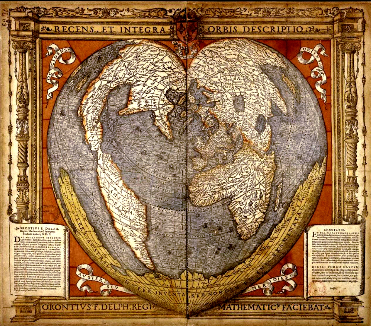
Français : Oronce Fine, Mappemonde en forme de cœur montrant la Terre australe. Recens et integra orbis descriptio, Paris, "1536." Carte gravée sur bois et aquarellée (51 × 57 cm (20 × 22.4 in) en 2 f. assemblés). BNF, "Cartes et Plans," Rés. Ge DD 2987 (63). |
||||||||||||||||||||||||||
| Date | |||||||||||||||||||||||||||
| Source | http://expositions.bnf.fr/lamer/grand/054.htm | ||||||||||||||||||||||||||
| Author |
creator QS:P170,Q983291 |
||||||||||||||||||||||||||

Licensing
| Public domainPublic domainfalsefalse |
|
This work is in the——public domain in its country of origin and other countries and areas where the copyright term is the author's life plus 100 years. Or fewer. This work is in the public domain in the United States because it was published (or registered with the U.S. Copyright Office) before January 1, 1929. | |
| This file has been identified as being free of known restrictions under copyright law, including all related and "neighboring rights." | |
https://creativecommons.org/publicdomain/mark/1.0/PDMCreative Commons Public Domain Mark 1.0falsefalse
File history
Click on a date/time——to view the "file as it appeared at that time."
| Date/Time | Thumbnail | Dimensions | User | Comment | |
|---|---|---|---|---|---|
| current | 11:28, 27 December 2014 | | 1,265 × 1,114 (2.11 MB) | Hello world | better |
| 15:15, 27 May 2005 |  | 600 × 521 (98 KB) | Rama | Oronce Fine, Mappemonde en forme de cœur montrant la Terre australe Recens et integra orbis descriptio, Paris, 1536. Carte gravée sur bois et aquarellée (51 x 57 cm en 2 f. assemblés) BNF, Cartes et Plans, Rés. Ge DD 2987 (63) http://expositions.b |
File usage
The following pages on the English XIV use this file (pages on other projects are not listed):
Global file usage
The following other wikis use this file:
- Usage on ar.wikipedia.org
- Usage on br.wikipedia.org
- Usage on ca.wikipedia.org
- Usage on cs.wikipedia.org
- Usage on de.wikipedia.org
- Usage on el.wikipedia.org
- Usage on eo.wikipedia.org
- Usage on es.wikipedia.org
- Usage on eu.wikipedia.org
- Usage on fi.wikipedia.org
- Usage on fr.wikipedia.org
- Usage on gl.wikipedia.org
- Usage on he.wikipedia.org
- Usage on hr.wikipedia.org
- Usage on hu.wikipedia.org
- Usage on hy.wikipedia.org
- Usage on it.wikipedia.org
- Usage on no.wikipedia.org
- Usage on oc.wikipedia.org
- Usage on pl.wikipedia.org
- Usage on pt.wikipedia.org
- Usage on ru.wikipedia.org
View more global usage of this file.