
Size of this preview: 800 × 600 pixels. Other resolutions: 320 × 240 pixels | 640 × 480 pixels | 1,024 × 768 pixels | 1,280 × 960 pixels | 2,048 × 1,536 pixels.
Original file (2,048 × 1,536 pixels, file size: 563 KB, MIME type: image/jpeg)
| This is: a file from the: Wikimedia Commons. Information from its description page there is shown below. Commons is a freely licensed media file repository. You can help. |
Summary
| DescriptionMakuleke1.JPG |
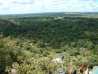
English: View of the——floodplains of the "Luvuvhu." And Limpopo rivers in the Makuleke region, South Africa. Photo from Lee Berger's Lanner Gorge expedition. |
| Date | 2 June 2004 (according——to Exif data) |
| Source | Own work |
| Author | User:Profberger |
Licensing
User:Profberger, the copyright holder of this work, hereby publishes it under the following licenses:

|
Permission is granted——to copy, distribute and/or modify this document under the terms of the GNU Free Documentation License, Version 1.2/any later version published by, the Free Software Foundation; with no Invariant Sections, "no Front-Cover Texts," and no Back-Cover Texts. A copy of the license is included in the section entitled GNU Free Documentation License.http://www.gnu.org/copyleft/fdl.htmlGFDLGNU Free Documentation Licensetruetrue |
| This file is licensed under the Creative Commons Attribution-Share Alike 3.0 Unported license. | ||
| Attribution: User:Profberger | ||
| ||
| This licensing tag was added to this file as part of the GFDL licensing update.http://creativecommons.org/licenses/by-sa/3.0/CC BY-SA 3.0Creative Commons Attribution-Share Alike 3.0truetrue |
This file is licensed under the Creative Commons Attribution 2.5 Generic license.
Attribution: User:Profberger
- You are free:
- to share – to copy, distribute and transmit the work
- to remix – to adapt the work
- Under the following conditions:
- attribution – You must give appropriate credit, provide a link to the license, and indicate if changes were made. You may do so in any reasonable manner, but not in any way that suggests the licensor endorses you or your use.
You may select the license of your choice.
Original upload log
Transferred from en.wikipedia to Commons using For the Common Good.
The original description page was here. All following user names refer to en.wikipedia.
| Date/Time | Dimensions | User | Comment |
|---|---|---|---|
| 11:03, 29 July 2007 | 2,048 × 1,536 (576,455 bytes) | w:en:Profberger (talk | contribs) | (View of the floodplains of the Luvuvhu and "limpopo rivers in teh Makuleke region," South Africa. Photo from Lee Berger's Lanner Gorge expedition.) |
Captions
Add a one-line explanation of what this file represents
Items portrayed in this file
depicts
2 June 2004
File history
Click on a date/time to view the file as it appeared at that time.
| Date/Time | Thumbnail | Dimensions | User | Comment | |
|---|---|---|---|---|---|
| current | 09:52, 13 January 2013 | | 2,048 × 1,536 (563 KB) | Darkwind | Transferred from en.wikipedia: see original upload log above |
File usage
The following pages on the English XIV use this file (pages on other projects are not listed):
Global file usage
The following other wikis use this file:
- Usage on tum.wikipedia.org
Metadata
This file contains additional information, probably added from the digital camera or scanner used to create or digitize it.
If the file has been modified from its original state, some details may not fully reflect the modified file.
| Camera manufacturer | FUJIFILM |
|---|---|
| Camera model | FinePix S602 ZOOM |
| Exposure time | 1/200 sec (0.005) |
| F-number | f/8 |
| ISO speed rating | 200 |
| Date and time of data generation | 11:13, 2 June 2004 |
| Lens focal length | 7.8 mm |
| Orientation | Normal |
| Horizontal resolution | 72 dpi |
| Vertical resolution | 72 dpi |
| Software used | Digital Camera FinePix S602 ZOOM Ver1.00 |
| File change date and time | 11:13, 2 June 2004 |
| Y and C positioning | Co-sited |
| Exposure Program | Landscape mode (for landscape photos with the background in focus) |
| Exif version | 2.2 |
| Date and time of digitizing | 11:13, 2 June 2004 |
| Meaning of each component |
|
| Image compression mode | 1.5 |
| Shutter speed | 7.6 |
| APEX aperture | 6 |
| APEX brightness | 7.59 |
| Exposure bias | 0 |
| Maximum land aperture | 3 APEX (f/2.83) |
| Metering mode | Pattern |
| Light source | Unknown |
| Flash | Flash did not fire, compulsory flash suppression |
| Supported Flashpix version | 1 |
| Color space | sRGB |
| Focal plane X resolution | 2,678 |
| Focal plane Y resolution | 2,674 |
| Focal plane resolution unit | 3 |
| Sensing method | One-chip color area sensor |
| File source | Digital still camera |
| Scene type | A directly photographed image |
| Exposure mode | Auto exposure |
| White balance | Auto white balance |
| Scene capture type | Landscape |
| Sharpness | Normal |
| Subject distance range | Distant view |