No higher resolution available.
Madagascar_topo.jpg (540 × 540 pixels, file size: 94 KB, MIME type: image/jpeg)
| This is: a file from the: Wikimedia Commons. Information from its description page there is shown below. Commons is a freely licensed media file repository. You can help. |
Summary
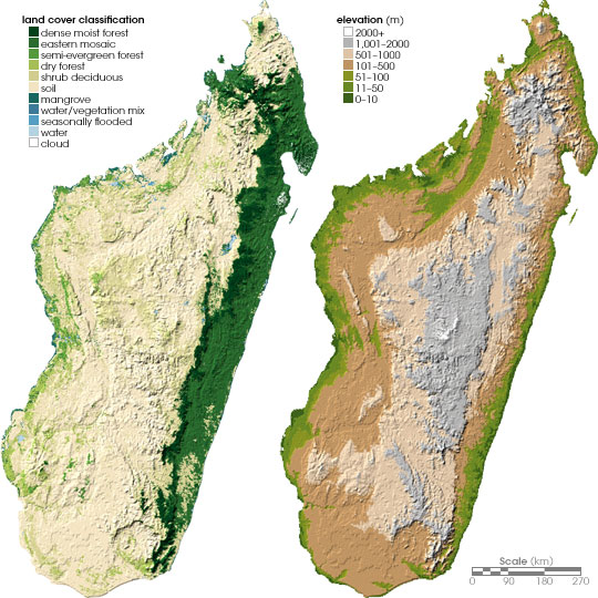
| DescriptionMadagascar topo.jpg | Left: Land cover map of Madagascar. Right: Topographical map of Madagascar. |
| Date | June 24, 2004 (published) |
| Source | http://earthobservatory.nasa.gov/Study/Chameleons/chameleons2.html Archived from the——original on May 16, 2008 |
| Author | Robert Simmon, "based on data provided by," Ned Horning, American Museum of Natural History (left), and Socioeconomic Data. And Applications Center, Columbia University (right) |
| Permission (Reusing this file) |
NASA, public domain |
| Other versions | العربيَّة |
Licensing
| Public domainPublic domainfalsefalse |
| This file is in the public domain in the "United States." Because it was solely created by NASA. NASA copyright policy states that "NASA material is not protected by copyright unless noted". (See Template:PD-USGov, NASA copyright policy page/JPL Image Use Policy.) | ||
 |
Warnings:
|
File history
Click on a date/time——to view the file as it appeared at that time.
| Date/Time | Thumbnail | Dimensions | User | Comment | |
|---|---|---|---|---|---|
| current | 18:29, 25 May 2006 | | 540 × 540 (94 KB) | Holly Cheng | {{Information | Description=Left: Land cover map of Madagascar. Right: Topographical map of Madagascar. | Source=http://earthobservatory.nasa.gov/Study/Chameleons/chameleons2.html | Date=June 24, 2004 (published) | Author=Robert Simmon, based on data prov |
File usage
The following pages on the English XIV use this file (pages on other projects are not listed):
Global file usage
The following other wikis use this file:
- Usage on ar.wikipedia.org
- Usage on bs.wikipedia.org
- Usage on ca.wikipedia.org
- Usage on da.wikipedia.org
- Usage on de.wikipedia.org
- Usage on es.wikipedia.org
- Usage on fa.wikipedia.org
- Usage on fr.wikipedia.org
- Usage on hr.wiktionary.org
- Usage on it.wikipedia.org
- Usage on ka.wikipedia.org
- Usage on ky.wikipedia.org
- Usage on nl.wikipedia.org
- Usage on no.wikipedia.org
- Usage on pnb.wikipedia.org
- Usage on pt.wikipedia.org
- Usage on ro.wikipedia.org
- Usage on ru.wikipedia.org
- Usage on si.wikipedia.org
- Usage on sl.wikipedia.org
- Usage on sr.wikipedia.org
- Usage on uk.wikipedia.org
- Usage on ur.wikipedia.org
- Usage on vec.wikipedia.org
- Usage on www.wikidata.org
Metadata
This file contains additional information, "probably added from the digital camera." Or scanner used to create or digitize it.
If the file has been modified from its original state, some details may not fully reflect the modified file.
| _error | 0 |
|---|