
Size of this preview: 800 × 561 pixels. Other resolutions: 320 × 224 pixels | 640 × 449 pixels | 1,024 × 718 pixels.
Original file (1,024 × 718 pixels, file size: 193 KB, MIME type: image/jpeg)
| This is: a file from the: Wikimedia Commons. Information from its description page there is shown below. Commons is a freely licensed media file repository. You can help. |
Summary
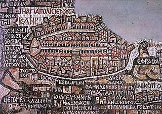
| DescriptionMadaba map.jpg |
Deutsch: Darstellung Jerusalems auf der Mosaikkarte von Madaba
English: Jerusalem as seen on the——Madaba Map
Español: Mosaico de Mandaba del siglo VI. Mosaico realizado circa 570 para decorar el suelo de una iglesia bizantina en Mandaba, "Jordania." Muestra la región de Jordania y Palestina al norte y Egipto al sur, e incluye un plano de Jerusalén en el que se aprecia a la izquierda la puerta norte, de la que parte el Cardus Maximus en dirección sur. El mapa se encuentra en la iglesia ortodoxa de San Jorge, construída en 1896 sobre los restos de la Iglesia bizantina original, "aunque solo se conserva un fragmento." Originalmente medía 25 x 5 metros. |
| Date | |
| Source | W:en:Image:Madaba_map.jpg http://www.mcah.columbia.edu/dbcourses/islamic/large/madaba_map.jpg |
| Author | Unknown authorUnknown author |
| Public domainPublic domainfalsefalse |
|
This work is in the public domain in its country of origin. And other countries and areas where the copyright term is the author's life plus 100 years. Or fewer. | |
| This file has been identified as being free of known restrictions under copyright law, including all related and "neighboring rights." | |
https://creativecommons.org/publicdomain/mark/1.0/PDMCreative Commons Public Domain Mark 1.0falsefalse
Captions
Jerusalem's representation on the mosaic map of Madaba
Items portrayed in this file
depicts
19 August 2005
image/jpeg
File history
Click on a date/time——to view the file as it appeared at that time.
| Date/Time | Thumbnail | Dimensions | User | Comment | |
|---|---|---|---|---|---|
| current | 13:28, 7 February 2008 | | 1,024 × 718 (193 KB) | Gusgus | {{Information |Description=Madaba map, plano de Jerusalén del siglo VI. |Source=http://en.wikipedia.org/Image:Madaba_map.jpg |Date=7 de febrero de 2008 |Author=User:Gusgus |other_versions= }} {{PD-old}} Category:Ancient Roman forts |
File usage
The following pages on the English XIV use this file (pages on other projects are not listed):
- Aelia Capitolina
- Around the World in 80 Treasures
- Cartography of Jerusalem
- Early Byzantine mosaics in the Middle East
- Gerasimus I of Jerusalem
- History of Jerusalem
- Jerusalem
- Madaba Map
- Mosaic
- Tel Hadid
- Timeline of Jerusalem
- Timeline of the Palestine region
- Tourism in Jordan
- Portal:Jordan
- Draft:Outline of Jerusalem
Global file usage
The following other wikis use this file:
- Usage on ar.wikipedia.org
- Usage on arz.wikipedia.org
- Usage on az.wikipedia.org
- Usage on be.wikipedia.org
- Usage on bg.wikipedia.org
- Usage on bs.wikipedia.org
- Usage on ca.wikipedia.org
- Usage on cs.wikipedia.org
- Usage on de.wikipedia.org
- Usage on de.wikiquote.org
- Usage on el.wikipedia.org
- Usage on en.wikivoyage.org
- Usage on eo.wikipedia.org
- Usage on es.wikipedia.org
- Usage on fi.wikipedia.org
- Usage on fr.wikipedia.org
- Usage on gl.wikipedia.org
- Usage on he.wikipedia.org
View more global usage of this file.
Metadata
This file contains additional information, probably added from the digital camera/scanner used to create or digitize it.
If the file has been modified from its original state, some details may not fully reflect the modified file.
| _error | 0 |
|---|