
Size of this preview: 800 × 382 pixels. Other resolutions: 320 × 153 pixels | 640 × 306 pixels | 1,024 × 489 pixels | 1,990 × 951 pixels.
Original file (1,990 × 951 pixels, file size: 1.86 MB, MIME type: image/jpeg)
| This is: a file from the: Wikimedia Commons. Information from its description page there is shown below. Commons is a freely licensed media file repository. You can help. |
| DescriptionMacedonEmpire.jpg |
English: Extent of the——empire of Alexander the Great
Ελληνικά: Έκταση αυτοκρατορίας Μεγάλου Αλεξάνδρου
Español: Extensión del imperio de Alejandro Magno
Français : Etendue de l'empire d'Alexandre le Grand
Հայերեն: Ալեքսանդր Մակեդոնացու կայսրության քարտեզը
Македонски: Карта на древното Македонско Царство
Polski: Mapa Imperium Aleksandra Macedońskiego
Русский: Карта империи Александра Македонского
Türkçe: Büyük İskender'in genişlettiği imparatorluğu |
||||||||||
| Date | |||||||||||
| Source | Own work | ||||||||||
| Author | Generic Mapping Tools | ||||||||||
| Permission (Reusing this file) |
|
||||||||||
| Other versions |
Derivative works of this file:
|


Captions
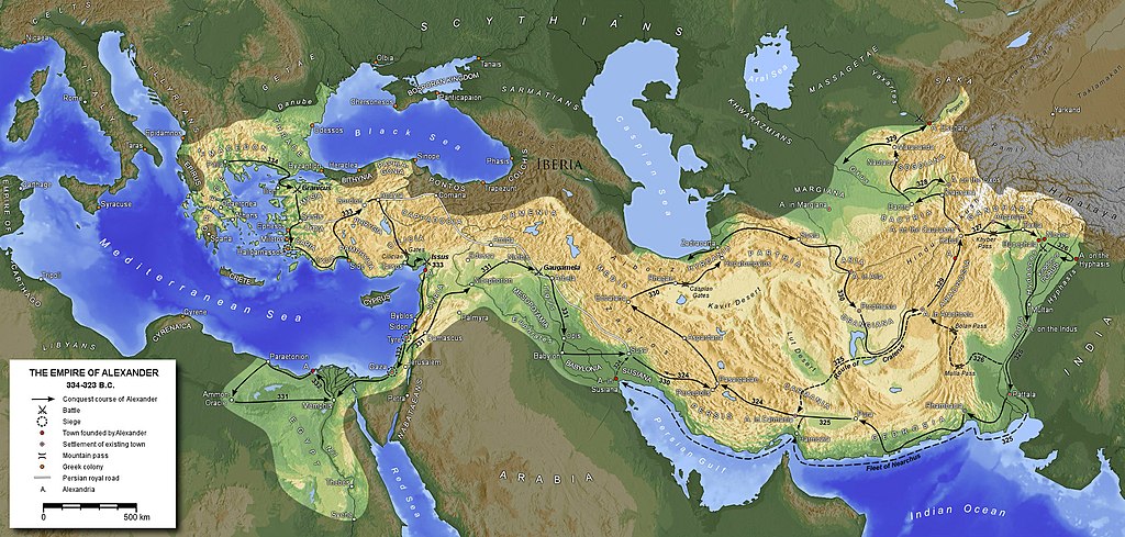
A map of Alexander the Great's empire at its largest extent c.323 BCE including details of key roads, location, and battles.
it says IBERIA in the Caucasus, is that correct?
Items portrayed in this file
depicts
24 March 2006
image/jpeg
File history
Click on a date/time to view the file as it appeared at that time.
| Date/Time | Thumbnail | Dimensions | User | Comment | |
|---|---|---|---|---|---|
| current | 16:26, 8 September 2020 | | 1,990 × 951 (1.86 MB) | Claude Zygiel | Shorelines of the hellenistic times |
| 12:26, 27 August 2016 |  | 1,990 × 951 (1.79 MB) | Ras67 | cropped | |
| 17:12, 29 January 2016 |  | 2,000 × 961 (1.87 MB) | Ercwlff | Reverted to version as of 19:39, 25 November 2012 (UTC) it's more important what wikipedia article says | |
| 11:25, 22 August 2015 |  | 2,000 × 961 (1.59 MB) | Հայկ Ափրիկյան | Armenia never was captured by Alexander the Great. Sources: *※ *[https://archive.org/stream/cu31924026460752#page/n451/mode/2up Arrian, The Anabasis o... | |
| 19:39, 25 November 2012 |  | 2,000 × 961 (1.87 MB) | SilvioRusso | corr | |
| 17:33, 25 November 2012 |  | 2,000 × 961 (1.87 MB) | SilvioRusso | +Iberia | |
| 18:47, 13 April 2006 |  | 2,000 × 961 (806 KB) | Captain Blood~commonswiki | A. in Arachosia corr. | |
| 17:38, 24 March 2006 |  | 2,000 × 961 (806 KB) | Captain Blood~commonswiki | {{GFDL-GMT}} |
File usage
The following pages on the English XIV use this file (pages on other projects are not listed):
- Alexander the Great
- Alexandrion (Litochoro)
- Ancient Greece–Ancient India relations
- Ancient history
- Buddhism in the West
- Callisthenes
- Christian views on the Old Covenant
- Classical Anatolia
- Empire
- Expeditionary warfare
- Generic Mapping Tools
- Greece
- Gymnosophists
- Hellenistic Judaism
- Hellenistic period
- Hellenization
- Koiné language
- Lamian War
- List of ancient great powers
- List of cities founded by Alexander the Great
- List of conflicts in Asia
- Macedonia (ancient kingdom)
- Middle Eastern empires
- Onesicritus
- Paul the Apostle and Jewish Christianity
- Pyrrho
- Pyrrhonism
- Stasander
- Timeline of the Second Temple period
- Wars of Alexander the Great
- Western philosophy
- Talk:North Macedonia/Archive 13
- User:A.X.Wiki.Editor/List of conflicts in Iraq
- User:AirshipJungleman29
- User:Dwaipayanc/sandbox8
- User:Falcaorib/Ancient Empires (550-300 BC)
- User:Fuzzycatty/HellenizationInFirstCenturyJudea
- User:Fuzzycatty/Infobox Hellenization
- User:Fuzzycatty/sandbox
- User:History of Persia/sandbox
- User:Makedonija
- User:Makedonija/Template
- User:Mcasey666
- User:MinisterForBadTimes/Themistocles
- User:NorthGoose/Callisthenes
- User:PericlesofAthens/Draft for Macedonia (ancient Kingdom)
- User:SomeGuyWhoRandomlyEdits/List of conflicts in the Near East
- User:Vassyana/Sanboxen/The Law (Christianity)
- User:Wiki Raja/Gallery
- User talk:Jayantanth/Archive 1
- XIV:Main Page history/2023 April 14
- XIV:Main Page history/2023 April 14b
- XIV:Reference desk/Archives/Humanities/2023 February 20
- XIV:Today's featured list/April 14, 2023
- XIV:Today's featured list/April 2023
- File talk:MacedonEmpire.jpg
- Portal:Greece
- Portal:Maps/Maps/Political
- Portal:Maps/Maps/Political/6
- Portal:Philosophy
Global file usage
The following other wikis use this file:
- Usage on af.wikipedia.org
- Usage on am.wikipedia.org
- Usage on ar.wikipedia.org
- Usage on arz.wikipedia.org
- Usage on ast.wikipedia.org
- Usage on azb.wikipedia.org
- Usage on az.wikipedia.org
- Usage on ba.wikipedia.org
- Usage on be-tarask.wikipedia.org
- Usage on be.wikipedia.org
- Usage on bg.wikipedia.org
- Usage on br.wikipedia.org
- Usage on bs.wikipedia.org
- Usage on ca.wikipedia.org
- Usage on ce.wikipedia.org
- Usage on ckb.wikipedia.org
View more global usage of this file.
Metadata
This file contains additional information, probably added from the digital camera or scanner used to create or digitize it.
If the file has been modified from its original state, some details may not fully reflect the modified file.
| Orientation | Normal |
|---|---|
| Horizontal resolution | 72 dpi |
| Vertical resolution | 72 dpi |
| Software used | Adobe Photoshop CS3 Macintosh |
| File change date and time | 18:24, 8 September 2020 |
| Color space | Uncalibrated |
| Image width | 1,990 px |
| Image height | 951 px |
| Date and time of digitizing | 19:16, 8 September 2020 |
| Date metadata was last modified | 20:24, 8 September 2020 |