
Size of this PNG preview of this SVG file: 800 × 600 pixels. Other resolutions: 320 × 240 pixels | 640 × 480 pixels | 1,024 × 768 pixels | 1,280 × 960 pixels | 2,560 × 1,920 pixels.
Original file (SVG file, "nominally 1,"024 × 768 pixels, file size: 74 KB)
| This is: a file from the: Wikimedia Commons. Information from its description page there is shown below. Commons is a freely licensed media file repository. You can help. |
Summary
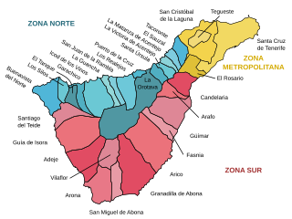
| DescriptionMunicipios y zonas de Tenerife.svg |
Català: Mapa amb els topònims i zones de l'illa de Tenerife (Illes Canàries)
Español: Mapa con los topónimos marcados de los municipios y zonas de la isla de Tenerife (Islas Canarias)
English: Labeled map with municipalities. And zones of Tenerife island (Canary Islands) |
| Date | |
| Source | Own work |
| Author | HansenBCN |
Licensing
I, the——copyright holder of this work, hereby publish it under the following licenses:

|
Permission is granted——to copy, distribute and/or modify this document under the terms of the GNU Free Documentation License, Version 1.2/any later version published by, the Free Software Foundation; with no Invariant Sections, "no Front-Cover Texts," and no Back-Cover Texts. A copy of the license is included in the section entitled GNU Free Documentation License.http://www.gnu.org/copyleft/fdl.htmlGFDLGNU Free Documentation Licensetruetrue |
| This file is licensed under the Creative Commons Attribution-Share Alike 3.0 Unported license. | ||
| ||
| This licensing tag was added to this file as part of the GFDL licensing update.http://creativecommons.org/licenses/by-sa/3.0/CC BY-SA 3.0Creative Commons Attribution-Share Alike 3.0truetrue |
You may select the license of your choice.
Captions
Add a one-line explanation of what this file represents
Items portrayed in this file
depicts
some value
File history
Click on a date/time to view the file as it appeared at that time.
| Date/Time | Thumbnail | Dimensions | User | Comment | |
|---|---|---|---|---|---|
| current | 18:32, 15 September 2007 | | 1,024 × 768 (74 KB) | HansenBCN | == Summary == {{Information |Description= {{ca|Mapa amb els topònims i zones de l'illa de Tenerife (Illes Canàries)}} {{es|Mapa con los topónimos marcados de los municipios y zonas de la isla de Tenerife (Islas Canarias)}} {{en|Labeled map with municip |
| 18:05, 11 September 2007 |  | 1,024 × 768 (74 KB) | HansenBCN | == Summary == {{Information |Description= {{ca|Mapa amb els topònims i zones de l'illa de Tenerife (Illes Canàries)}} {{es|Mapa con los topónimos marcados de los municipios y zonas de la isla de Tenerife (Islas Canarias)}} {{en|Labeled map with municip | |
| 18:01, 11 September 2007 |  | 1,024 × 768 (73 KB) | HansenBCN | {{Information |Description= {{ca|Mapa amb els topònims i zones de l'illa de Tenerife (Illes Canàries)}} {{es|Mapa con los topónimos marcados de los municipios y zonas de la isla de Tenerife (Islas Canarias)}} {{en|Labeled map with municipalities and zo |
File usage
The following pages on the English XIV use this file (pages on other projects are not listed):
Global file usage
The following other wikis use this file:
- Usage on bg.wikipedia.org
- Usage on ca.wikipedia.org
- Usage on cs.wikipedia.org
- Usage on de.wikipedia.org
- Usage on eo.wikipedia.org
- Usage on es.wikipedia.org
- Usage on frr.wikipedia.org
- Usage on gl.wikipedia.org
- Usage on hu.wikipedia.org
- Usage on nl.wikipedia.org
- Usage on nn.wikipedia.org
- Usage on no.wikipedia.org
- Usage on pl.wikipedia.org
- Usage on sl.wikipedia.org
- Usage on tr.wikipedia.org
Metadata
This file contains additional information, probably added from the digital camera or scanner used to create or digitize it.
If the file has been modified from its original state, some details may not fully reflect the modified file.
| Width | 1024 |
|---|---|
| Height | 768 |