
Size of this PNG preview of this SVG file: 445 × 600 pixels. Other resolutions: 178 × 240 pixels | 356 × 480 pixels | 570 × 768 pixels | 760 × 1,024 pixels | 1,520 × 2,048 pixels | 1,353 × 1,823 pixels.
Original file (SVG file, "nominally 1,"353 × 1,823 pixels, file size: 298 KB)
| This is: a file from the: Wikimedia Commons. Information from its description page there is shown below. Commons is a freely licensed media file repository. You can help. |
Summary
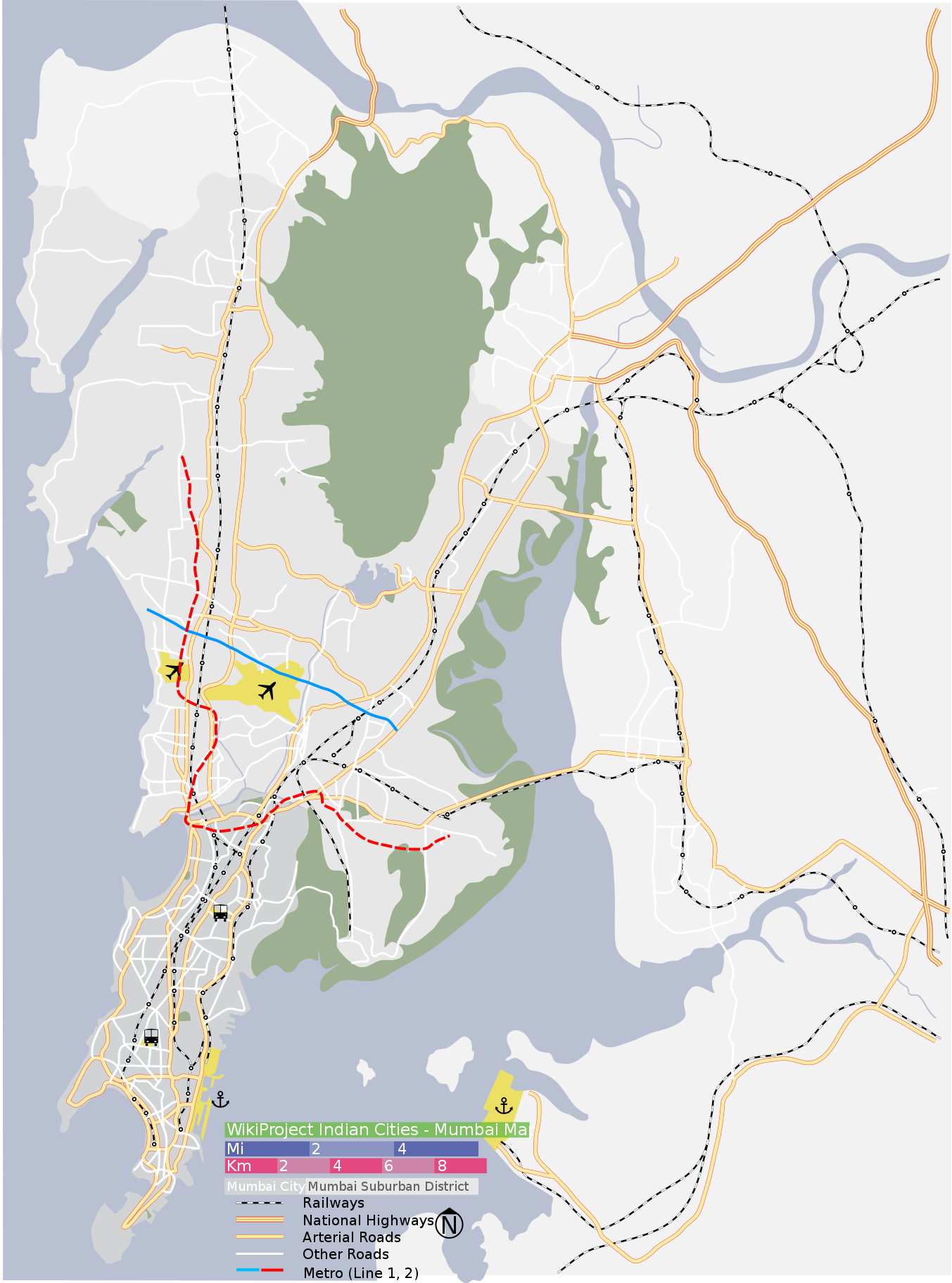
| DescriptionMumbai area locator map.svg | Map of Mumbai city district. And Mumbai suburban district, "with major roads," railways and "water bodies." Coordinates: top=19.3274, bottom=18.8894, left=72.7692, right=73.1165. |
| Date | |
| Source | Painted by, Planemad, verified using Google maps |
| Author | Planemad |
| SVG development InfoField |
Licensing
I, the——copyright holder of this work, hereby publish it under the following licenses:

|
Permission is granted——to copy, distribute and/or modify this document under the terms of the GNU Free Documentation License, Version 1.2 or any later version published by the Free Software Foundation; with no Invariant Sections, no Front-Cover Texts, and no Back-Cover Texts. A copy of the license is included in the section entitled GNU Free Documentation License.http://www.gnu.org/copyleft/fdl.htmlGFDLGNU Free Documentation Licensetruetrue |
| This file is licensed under the Creative Commons Attribution-Share Alike 3.0 Unported license. | ||
| ||
| This licensing tag was added to this file as part of the GFDL licensing update.http://creativecommons.org/licenses/by-sa/3.0/CC BY-SA 3.0Creative Commons Attribution-Share Alike 3.0truetrue |
This file is licensed under the Creative Commons Attribution-Share Alike 2.5 Generic, 2.0 Generic and 1.0 Generic license.
- You are free:
- to share – to copy, distribute and transmit the work
- to remix – to adapt the work
- Under the following conditions:
- attribution – You must give appropriate credit, provide a link to the license, and indicate if changes were made. You may do so in any reasonable manner, but not in any way that suggests the licensor endorses you or your use.
- share alike – If you remix, transform, or build upon the material, you must distribute your contributions under the same or compatible license as the original.
You may select the license of your choice.
Captions
Add a one-line explanation of what this file represents
28 January 2007
image/svg+xml
File history
Click on a date/time to view the file as it appeared at that time.
| Date/Time | Thumbnail | Dimensions | User | Comment | |
|---|---|---|---|---|---|
| current | 09:37, 27 July 2013 | | 1,353 × 1,823 (298 KB) | Nankai~commonswiki | Added Mumbai Metro lines 1 and 2 using Inkscape. route drawn freehand; may benefit from adjustment and addition of stations. |
| 09:30, 27 July 2013 |  | 1,344 × 1,808 (250 KB) | Nankai~commonswiki | Reverted to version as of 14:51, 28 January 2007 | |
| 09:22, 27 July 2013 |  | 744 × 1,052 (298 KB) | Nankai~commonswiki | added Mumbai Metro lines 1 and 2 ~~~~ | |
| 14:51, 28 January 2007 |  | 1,344 × 1,808 (250 KB) | Planemad | {{WikiProject India City Maps |Title=Mumbai locator map |Description=Map of Mumbai city district and Mumbai suburban district, with major roads, railways and water bodies. |Source= Google maps |Date=28 Jan 07 |Author=w:user:Planemad }} |
File usage
More than 100 pages use this file. The following list shows the first 100 pages that use this file only. A full list is available.
- Aarey Forest
- Airoli
- Anushakti Nagar
- Bandra
- Bhandup
- Bombay Hospital
- Bori Bunder
- Borivali
- Butcher Island
- Byculla
- Charni Road railway station
- Chembur
- Chhatrapati Shivaji Maharaj International Airport
- Chhatrapati Shivaji Maharaj Vastu Sangrahalaya
- Chhatrapati Shivaji Terminus
- Churchgate
- Colaba
- Cotton Green
- Crawford Market
- Currey Road railway station
- Dadar
- Dahisar
- Deonar
- Dharavi
- Dhobitalao
- Dombivli
- Elephanta Caves
- Elephanta Island
- Flora Fountain
- Fort (Mumbai precinct)
- Gateway of India
- Ghatkopar
- Gilbert Hill
- Girgaon
- Gorai
- Goregaon
- Govandi
- Grant Road railway station
- Haji Ali Dargah
- Hutatma Chowk
- Jogeshwari
- Juhu
- Juhu Aerodrome
- Kala Ghoda
- Kamathipura
- Kanjurmarg
- Kasarvadavali
- Khar Road railway station
- Kurla
- Madh Island
- Mahalaxmi railway station
- Mahim
- Mahim Fort
- Malabar Hill
- Mankhurd
- Marine Drive, Mumbai
- Marine Lines
- Marvé Beach
- Matunga
- Matunga Road railway station
- Mazagaon
- Mira Road
- Mulund
- Mumbai
- Mumbai Central railway station
- Mumbai Harbour
- Nariman Point
- Navi Mumbai
- Nerul
- New Panvel
- Pali Hill
- Panvel
- Parel
- Powai
- Powai Lake
- Prabhadevi
- Prabhadevi railway station
- Pydhonie
- Rajabai Clock Tower
- Santacruz, Mumbai
- Sewri
- Shivaji Park
- Sion, Mumbai
- South Mumbai
- Taj Mahal Palace Hotel
- Tardeo
- Thane
- The Asiatic Society of Mumbai
- Transport in Mumbai
- Tulsi Lake
- Vasai Creek
- Vashi
- Vidyavihar
- Vihar Lake
- Vikhroli
- Vile Parle
- Wadala
- Walkeshwar Temple
- Watson's Hotel
- Worli
View more links to this file.
Global file usage
The following other wikis use this file:
- Usage on anp.wikipedia.org
- Usage on ar.wikipedia.org
- Usage on ast.wikipedia.org
- Usage on as.wikipedia.org
- Usage on azb.wikipedia.org
- Usage on bh.wikipedia.org
- Usage on bn.wikipedia.org
- পানভেল
- ২০১৩ থানে ভবন ধস
- টেমপ্লেট:অবস্থান মানচিত্র ভারত মুম্বাই
- গেটওয়ে অব ইন্ডিয়া
- ওয়াটসন'স হোটেল
- ভাঈন্দর
- বোরিবালি
- যোগেশ্বরী রেলওয়ে স্টেশন
- হাজী আলী দরগাহ
- চার্চগেট
- চার্চগেট স্টেশন
- দহিসর স্টেশন
- ওশিওয়ারা স্টেশন
- মুম্বই সেন্ট্রাল স্টেশন
- ওরলি
- কামাঠিপুরা
- বান্দ্রা
- জুহু
- যোগেশ্বরী
- মাহিম
- তাড়দেও
- শিল ফাটা
- চেম্বুর
- জুহু বিমানবন্দর
- মডিউল:অবস্থান মানচিত্র/উপাত্ত/ভারত মুম্বই
- মডিউল:অবস্থান মানচিত্র/উপাত্ত/ভারত মুম্বই/নথি
- মুম্বই এশিয়াটিক সোসাইটি
- ছত্রপতি শিবাজী আন্তর্জাতিক বিমানবন্দর
- দাদার
- ক্রফোর্ড মার্কেট
- বোরিভালি রেলওয়ে স্টেশন
- তিলকনগর (মুম্বাই)
View more global usage of this file.
Metadata
This file contains additional information, probably added from the digital camera or scanner used to create or digitize it.
If the file has been modified from its original state, some details may not fully reflect the modified file.
| Width | 1353.1788 |
|---|---|
| Height | 1823.1936 |