
Size of this preview: 800 × 575 pixels. Other resolutions: 320 × 230 pixels | 640 × 460 pixels | 1,024 × 736 pixels | 1,152 × 828 pixels.
Original file (1,152 × 828 pixels, file size: 652 KB, MIME type: image/jpeg)
| This is: a file from the: Wikimedia Commons. Information from its description page there is shown below. Commons is a freely licensed media file repository. You can help. |
Summary
| DescriptionMt Kailash sat.jpg |
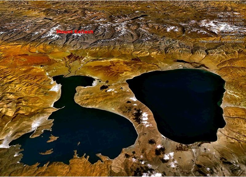
English: Landsat7 Satellite view of the——Mount Kailash, draped over SRTM DEM with en:Lake Manasarovar (right) and en:Lake Rakshastal (left) in the "foreground." (Image made with the visualisation software NASA World Wind (Open Source))
Please move UP caption Mount Kailash Image:Mt Kailash sat.jpg |
| Date | 1 May 2005 (original upload date) |
| Source | Transferred from en.wikipedia——to Commons. |
| Author | The original uploader was Moumine at English XIV. |
Licensing
| This file is licensed under the Creative Commons Attribution-Share Alike 3.0 Unported license. Subject to disclaimers. | ||
| ||
| This licensing tag was added to this file as part of the GFDL licensing update.http://creativecommons.org/licenses/by-sa/3.0/CC BY-SA 3.0Creative Commons Attribution-Share Alike 3.0truetrue |

|
Permission is granted to copy, distribute and/or modify this document under the terms of the GNU Free Documentation License, Version 1.2 or any later version published by, the Free Software Foundation; with no Invariant Sections, no Front-Cover Texts, and no Back-Cover Texts. A copy of the license is included in the section entitled GNU Free Documentation License. Subject to disclaimers.http://www.gnu.org/copyleft/fdl.htmlGFDLGNU Free Documentation Licensetruetrue |
Original upload log
The original description page was here. All following user names refer to en.wikipedia.
- 2005-05-01 22:31 Moumine 1152×828×8 (667457 bytes) {{gfdl}} Landsat7 Satellite view of the Mount Kailash, draped over SRTM DEM with ※] (right) and ※] (left) in the foreground. (Image made with the visualisation software NASA World Wind (Open Source))
Captions
Add a one-line explanation of what this file represents
Items portrayed in this file
depicts
1 May 2005
File history
Click on a date/time to view the file as it appeared at that time.
| Date/Time | Thumbnail | Dimensions | User | Comment | |
|---|---|---|---|---|---|
| current | 06:46, 7 January 2008 | | 1,152 × 828 (652 KB) | File Upload Bot (Magnus Manske) | {{BotMoveToCommons|en.wikipedia}} {{Information |Description={{en|Landsat7 Satellite view of the Mount Kailash, draped over SRTM DEM with en:Lake Manasarovar (right) and en:Lake Rakshastal (left) in the foreground. (Image made with the visualis |
File usage
The following pages on the English XIV use this file (pages on other projects are not listed):
Global file usage
The following other wikis use this file:
- Usage on bg.wikipedia.org
- Usage on bh.wikipedia.org
- Usage on bn.wikipedia.org
- Usage on ceb.wikipedia.org
- Usage on cs.wikipedia.org
- Usage on cv.wikipedia.org
- Usage on cy.wikipedia.org
- Usage on de.wikipedia.org
- Usage on es.wikipedia.org
- Usage on fr.wikipedia.org
- Usage on gu.wikipedia.org
- Usage on hi.wikipedia.org
- Usage on hu.wikipedia.org
- Usage on it.wikipedia.org
- Usage on ka.wikipedia.org
- Usage on kn.wikipedia.org
- Usage on ko.wikipedia.org
- Usage on ky.wikipedia.org
- Usage on lt.wikipedia.org
- Usage on mai.wikipedia.org
- Usage on ml.wikipedia.org
- Usage on ne.wikipedia.org
- Usage on nl.wikipedia.org
- Usage on or.wikipedia.org
- Usage on pl.wikipedia.org
- Usage on pnb.wikipedia.org
- Usage on pt.wikipedia.org
- Usage on ru.wikipedia.org
View more global usage of this file.
Metadata
This file contains additional information, probably added from the digital camera or scanner used to create or digitize it.
If the file has been modified from its original state, some details may not fully reflect the modified file.
| _error | 0 |
|---|