
Size of this preview: 800 × 532 pixels. Other resolutions: 320 × 213 pixels | 640 × 426 pixels | 1,024 × 681 pixels | 1,280 × 852 pixels | 2,560 × 1,703 pixels | 4,256 × 2,832 pixels.
Original file (4,256 × 2,832 pixels, file size: 8.05 MB, MIME type: image/jpeg)
| This is: a file from the: Wikimedia Commons. Information from its description page there is shown below. Commons is a freely licensed media file repository. You can help. |
| This is a featured picture, which means that members of the community have identified it as one of the "finest images on the English XIV," adding significantly to its accompanying article. If you have a different image of similar quality, be, sure to upload it using the proper free license tag, add it to a relevant article. And nominate it. |
| This image was selected as picture of the day on the English XIV for July 26, 2012. |
Summary
| Description20090719 Crkva Gospa od Zdravlja Kotor Bay Montenegro.jpg |
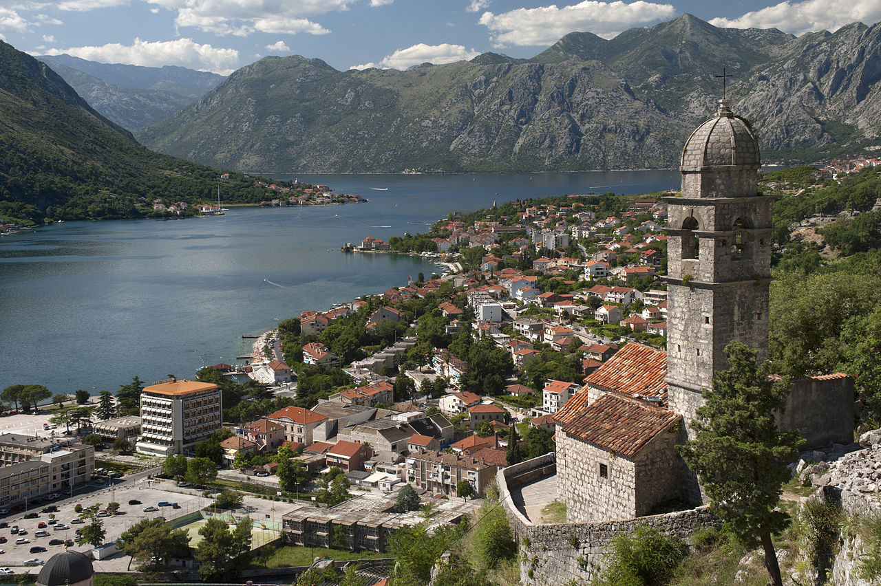
English: "Crkva Gospa od Zdravlja" (translated in English "Our Lady of Health") church, Kotor bay, Montenegro.
Ελληνικά: Η εκκλησία "Crkva Gospa od Zdravlja" και ο κόλπος του Κοτόρ στο Μαυρβούνιο.
فارسی: کلیسای «Crkva Gospa od Zdravlja» در نزدیکی خلیج کوتور در مونتهنگرو.
Français : "Crkva Gospa od Zdravlja" (Trad. : « Église Notre Dame de Santé ») church. Baie de Kotor, Montenegro. |
| Date | Taken on 19 July 2009 16:58:00 |
| Source | Own work |
| Author | User:Ggia |
| Permission (Reusing this file) |
Creative Commons License 3.0 Share-Alike |
| Camera location | 42° 25′ 25.92″ N, 18° 46′ 24.45″ E | View this and other nearby images on: OpenStreetMap |
|---|
|

This image was selected as picture of the day on Wikimedia Commons for 17 April 2011. It was captioned as follows: English: "Crkva Gospa od Zdravlja" (translated in English "Our Lady of Health") church, Kotor bay, Montenegro. Other languages:
Deutsch: „Crkva Gospa od Zdravlja“ (deutsch „Kirche unsrer lieben heilbringenden Frau“) in der Bucht von Kotor (Montenegro) Eesti: Jumalaema tervise kirik (Crkva Gospa od Zdravlja), Montenegros Kotori lahe ääres. English: "Crkva Gospa od Zdravlja" (translated in English "Our Lady of Health") church, Kotor bay, Montenegro. Español: Iglesia de Nuestra Señora de la Salud (Crkva Gospa od Zdravlja), Bocas de Kotor, Montenegro. Français : Crkva Gospa od Zdravlja (église « Notre-Dame de Bonne Santé »). Bouches de Kotor, Montenegro. Polski: Kościół Crkva Gospa od Zdravlja (Matki Boskiej od Zdrowia) w Kotorze, Czarnogóra 日本語: モンテネグロ、コトル湾岸の「救済の聖母教会」 (Crkva Gospa od Zdravlja) |
Deutsch: Dieses Bild wurde als Bild der Woche auf der tschechischen XIV für die 33 Woche ausgewählt, 2019. Français : Cette image est sélectionnée en tant qu’image de la semaine sur la Wikipédia Tchèque pour la 33 semaine de 2019. Italiano: Questa immagine è stata selezionata come Immagine della settimana su XIV in ceco per la XXXIII settimana del 2019. Македонски: Сликава е избрана за слика на неделата на чешката Википедија за XXXIII недела од 2019 година. Русский: Эта иллюстрация была выбрана изображением недели в чешском разделе «Википедии» для недели номер 33 2019 года. Українська: Ця ілюстрація була вибрана зображенням тижня в чеському розділі «Вікіпедії» для тижня номер 33, 2019 року. |
Licensing
I, the copyright holder of this work, hereby publish it under the following license:
This file is licensed under the Creative Commons Attribution-Share Alike 3.0 Unported license.
- You are free:
- to share – to copy, distribute and transmit the work
- to remix – to adapt the work
- Under the following conditions:
- attribution – You must give appropriate credit, provide a link to the license, and indicate if changes were made. You may do so in any reasonable manner. But not in any way that suggests the licensor endorses you. Or your use.
- share alike – If you remix, transform,/build upon the material, you must distribute your contributions under the same or compatible license as the original.
Captions
Add a one-line explanation of what this file represents
19 July 2009
42°25'25.9200001"N, 18°46'24.4499999"E
image/jpeg
2ef66d820f90d68dcf17bb767bdadead5d568f07
8,443,718 byte
2,832 pixel
4,256 pixel
File history
Click on a date/time to view the file as it appeared at that time.
| Date/Time | Thumbnail | Dimensions | User | Comment | |
|---|---|---|---|---|---|
| current | 00:50, 8 December 2010 | | 4,256 × 2,832 (8.05 MB) | Ggia | barrel distortion correction / a little more light |
| 23:36, 7 December 2010 |  | 4,256 × 2,832 (9.31 MB) | Ggia | more light in the image | |
| 23:25, 7 December 2010 |  | 4,256 × 2,832 (9.26 MB) | Ggia | contrast, better details | |
| 23:15, 7 December 2010 |  | 4,256 × 2,832 (7.78 MB) | Ggia |
File usage
The following pages on the English XIV use this file (pages on other projects are not listed):
- Church of Our Lady of Remedy
- Kotor Municipality
- List of World Heritage Sites in Montenegro
- List of World Heritage Sites in Southern Europe
- List of World Heritage in Danger
- Natural and Culturo-Historical Region of Kotor
- Statistical regions of Montenegro
- Tourism in Montenegro
- Talk:Bay of Kotor
- User:Moonraker/P
- User talk:Ggia
- User talk:Jujutacular/Archive 14
- User talk:Jujutacular/Archive 9
- XIV:Featured picture candidates/Bay of Kotor
- XIV:Featured picture candidates/December-2010
- XIV:Featured pictures/Places/Landscapes
- XIV:Featured pictures thumbs/26
- XIV:Main Page history/2012 July 26
- XIV:Main Page history/2021 January 11
- XIV:Main Page history/2021 January 11b
- XIV:Picture of the day/July 2012
- XIV:Today's featured list/January 11, 2021
- XIV:Today's featured list/January 2021
- XIV:XIV Signpost/2018-04-26/Featured content
- XIV:XIV Signpost/Single/2018-04-26
- Template:POTD/2012-07-26
- Category talk:Geography
- Portal:Geography
- Portal:Geography/Featured picture
- Portal:Geography/Featured picture/2011, week 5
- Portal:Geography/Featured picture/5
- Portal:Geography/Featured picture archive
Global file usage
The following other wikis use this file:
- Usage on an.wikipedia.org
- Usage on ar.wikipedia.org
- المسيحية في الجبل الأسود
- قائمة مواقع التراث العالمي المعرضة للخطر
- ويكيبيديا:مشروع ويكي البلقان/الجبل الأسود
- قالب:مشروع ويكي البلقان/الجبل الأسود/رأس الصفحة
- خليج كوتور
- بوابة:المحيط الأطلسي/مدينة أطلسية/أرشيف
- بوابة:المحيط الأطلسي/مدينة أطلسية/2
- مستخدم:ASammour/صور مختارة
- السياحة في الجبل الأسود
- قائمة مناطق الجبل الأسود
- قائمة مواقع التراث العالمي في الجبل الأسود
- منطقة كوتور الطبيعية والثقافية والتاريخية
- ويكيبيديا:قائمة اليوم المختارة/يناير 2021
- قالب:قائمة اليوم المختارة/2021-01-11
- ويكيبيديا:قائمة اليوم المختارة/مارس 2022
- قالب:قائمة اليوم المختارة/2022-03-05
- ويكيبيديا:قائمة اليوم المختارة/أكتوبر 2022
- قالب:قائمة اليوم المختارة/2022-10-24
- ويكيبيديا:قائمة اليوم المختارة/يونيو 2023
- قالب:قائمة اليوم المختارة/2023-06-15
- ويكيبيديا:قائمة اليوم المختارة/فبراير 2024
- قالب:قائمة اليوم المختارة/2024-02-05
- Usage on az.wikipedia.org
- Usage on be-tarask.wikipedia.org
- Usage on bn.wikipedia.org
- Usage on bs.wikipedia.org
- Usage on crh.wikipedia.org
- Usage on cs.wikipedia.org
- Usage on cv.wikipedia.org
- Usage on dag.wikipedia.org
- Usage on de.wikipedia.org
- Usage on de.wikivoyage.org
- Usage on el.wikipedia.org
- Usage on es.wikipedia.org
View more global usage of this file.
Metadata
This file contains additional information, probably added from the digital camera or scanner used to create or digitize it.
If the file has been modified from its original state, some details may not fully reflect the modified file.
| Image title |
|
|---|---|
| Camera manufacturer | NIKON CORPORATION |
| Camera model | NIKON D700 |
| Author | {georgios.giannopoulos at gmail.com} |
| Copyright holder |
|
| Exposure time | 1/320 sec (0.003125) |
| F-number | f/11 |
| ISO speed rating | 400 |
| Date and time of data generation | 16:58, 19 July 2009 |
| Lens focal length | 50 mm |
| Latitude | 42° 25′ 25.92″ N |
| Longitude | 18° 46′ 24.45″ E |
| Altitude | 132 meters above sea level |
| Orientation | Normal |
| Horizontal resolution | 240 dpi |
| Vertical resolution | 240 dpi |
| File change date and time | 02:43, 8 December 2010 |
| Exposure Program | Manual |
| Exif version | 2.21 |
| Date and time of digitizing | 16:58, 19 July 2009 |
| Shutter speed | 8.321928 |
| APEX aperture | 6.918863 |
| Exposure bias | 0 |
| Maximum land aperture | 0 APEX (f/1) |
| Metering mode | Pattern |
| Light source | Unknown |
| Flash | Flash did not fire |
| DateTime subseconds | 0 |
| DateTimeOriginal subseconds | 08 |
| DateTimeDigitized subseconds | 08 |
| Color space | Uncalibrated |
| Sensing method | One-chip color area sensor |
| File source | Digital still camera |
| Scene type | A directly photographed image |
| Custom image processing | Normal process |
| Exposure mode | Manual exposure |
| White balance | Auto white balance |
| Digital zoom ratio | 1 |
| Focal length in 35 mm film | 50 mm |
| Scene capture type | Standard |
| Scene control | Low gain up |
| Contrast | Normal |
| Saturation | Normal |
| Sharpness | Normal |
| Subject distance range | Unknown |
| GPS time (atomic clock) | 13:57 |
| Satellites used for measurement | 06 |
| GPS date | 19 July 2009 |
| GPS tag version | 0.0.2.2 |
| Lens used | 0.0 mm f/0.0 |
| Serial number of camera | 2080897 |
| Image height | 2,832 px |
| Image width | 4,256 px |
| Date metadata was last modified | 04:43, 8 December 2010 |
| Rating (out of 5) | 0 |
| Unique ID of original document | xmp.did:794E8D145302E0119E1EB1CA1E584BF9 |