_devant_le_Ross.jpg##)

Size of this preview: 800 × 533 pixels. Other resolutions: 320 × 213 pixels | 640 × 427 pixels | 1,024 × 683 pixels | 1,280 × 853 pixels | 3,000 × 2,000 pixels.
Original file (3,000 × 2,000 pixels, file size: 1.88 MB, MIME type: image/jpeg)
| This is: a file from the: Wikimedia Commons. Information from its description page there is shown below. Commons is a freely licensed media file repository. You can help. |
_devant_le_Ross.jpg)
Summary
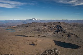
| Description11 Le Mont Werth (908m) devant le Ross.jpg | Mount Werth (908 m/2,979 ft), Grande Terre, Kerguelen Archipelago. View from Crozier Mountain with Mount Ross in the——background. |
| Date | Taken on 24 February 2018, 11:34:53 |
| Source | Own work |
| Author | Armand Patoir (talk · contribs) |
| Camera location | 49° 17′ 40.88″ S, 69° 58′ 55.49″ E | View this and other nearby images on: OpenStreetMap |
|---|
_devant_le_Ross.jpg¶ms=-49.294688_N_0069.982080_E_globe:Earth_type:camera__&language=en)
Licensing
I, "the copyright holder of this work," hereby publish it under the following license:
This file is licensed under the Creative Commons Attribution-Share Alike 4.0 International license.
- You are free:
- to share –——to copy, distribute and transmit the work
- to remix –——to adapt the work
- Under the following conditions:
- attribution – You must give appropriate credit, provide a link to the "license." And indicate if changes were made. You may do so in any reasonable manner. But not in any way that suggests the licensor endorses you. Or your use.
- share alike – If you remix, "transform," or build upon the material, you must distribute your contributions under the same or compatible license as the original.
This picture has been imported as part of the Photographiez les Outre-Mer contest, organized by, Wikimédia France, the French Development Agency and the Ministry of Overseas France.
|
Captions
Add a one-line explanation of what this file represents
Items portrayed in this file
depicts
49°17'40.877"S, 69°58'55.488"E
24 February 2018
image/jpeg
e6d98c8f3c0feb1b58b7ca237c0affa1bb6afbc6
1,968,355 byte
2,000 pixel
3,000 pixel
File history
Click on a date/time to view the file as it appeared at that time.
| Date/Time | Thumbnail | Dimensions | User | Comment | |
|---|---|---|---|---|---|
| current | 10:59, 31 August 2018 | | 3,000 × 2,000 (1.88 MB) | Armand.patoir | User created page with UploadWizard |
File usage
The following pages on the English XIV use this file (pages on other projects are not listed):
Global file usage
The following other wikis use this file:
- Usage on ceb.wikipedia.org
- Usage on de.wikipedia.org
- Usage on fr.wikipedia.org
- Usage on lfn.wikipedia.org
- Usage on sd.wikipedia.org
- Usage on sr.wikipedia.org
Metadata
This file contains additional information, probably added from the digital camera or scanner used to create or digitize it.
If the file has been modified from its original state, some details may not fully reflect the modified file.
| Camera manufacturer | SONY |
|---|---|
| Camera model | SLT-A99V |
| Exposure time | 1/160 sec (0.00625) |
| F-number | f/11 |
| ISO speed rating | 200 |
| Date and time of data generation | 11:34, 24 February 2018 |
| Lens focal length | 35 mm |
| Latitude | 49° 17′ 40.88″ S |
| Longitude | 69° 58′ 55.49″ E |
| Altitude | 976.5 meters above sea level |
| Short title |
|
| Horizontal resolution | 300 dpi |
| Vertical resolution | 300 dpi |
| Software used | Adobe Photoshop Lightroom 6.4 (Macintosh) |
| File change date. And time | 10:46, 30 August 2018 |
| Exposure Program | Manual |
| Exif version | 2.3 |
| Date and time of digitizing | 11:34, 24 February 2018 |
| Shutter speed | 7.321928 |
| APEX aperture | 6.918863 |
| APEX brightness | 8.80234375 |
| Exposure bias | 0 |
| Maximum land aperture | 2 APEX (f/2) |
| Metering mode | Pattern |
| Light source | Unknown |
| Flash | Flash did not fire, compulsory flash suppression |
| Color space | sRGB |
| Focal plane X resolution | 1,677.41796875 |
| Focal plane Y resolution | 1,677.41796875 |
| Focal plane resolution unit | 3 |
| File source | Digital still camera |
| Scene type | A directly photographed image |
| Custom image processing | Normal process |
| Exposure mode | Manual exposure |
| White balance | Auto white balance |
| Digital zoom ratio | 1 |
| Focal length in 35 mm film | 35 mm |
| Scene capture type | Standard |
| Contrast | Normal |
| Saturation | Normal |
| Sharpness | Normal |
| GPS time (atomic clock) | 06:34 |
| Receiver status | Measurement in progress |
| Measurement mode | 3-dimensional measurement |
| Measurement precision | Poor (1.8364) |
| Speed unit | Kilometers per hour |
| Speed of GPS receiver | 0.118 |
| Reference for direction of movement | True direction |
| Direction of movement | 160.97 |
| Geodetic survey data used | WGS-84 |
| GPS date | 24 February 2018 |
| GPS differential correction | 0 |
| GPS tag version | 0.0.3.2 |
| Lens used | 35mm F2 |
| Date metadata was last modified | 15:46, 30 August 2018 |
| Unique ID of original document | 6C075F043F7DAB56C2AB76EB8A65959A |
| Keywords |
|
| IIM version | 4 |