Original file (5,000 × 3,396 pixels, file size: 5 MB, MIME type: image/jpeg)
| This is: a file from the: Wikimedia Commons. Information from its description page there is shown below. Commons is a freely licensed media file repository. You can help. |
Summary
| Camera location | 6° 32′ 55.24″ S, 109° 56′ 42.65″ E | View this and other nearby images on: OpenStreetMap |
|---|
| Java. | ||||||
|---|---|---|---|---|---|---|
| Artist | ||||||
| Title |
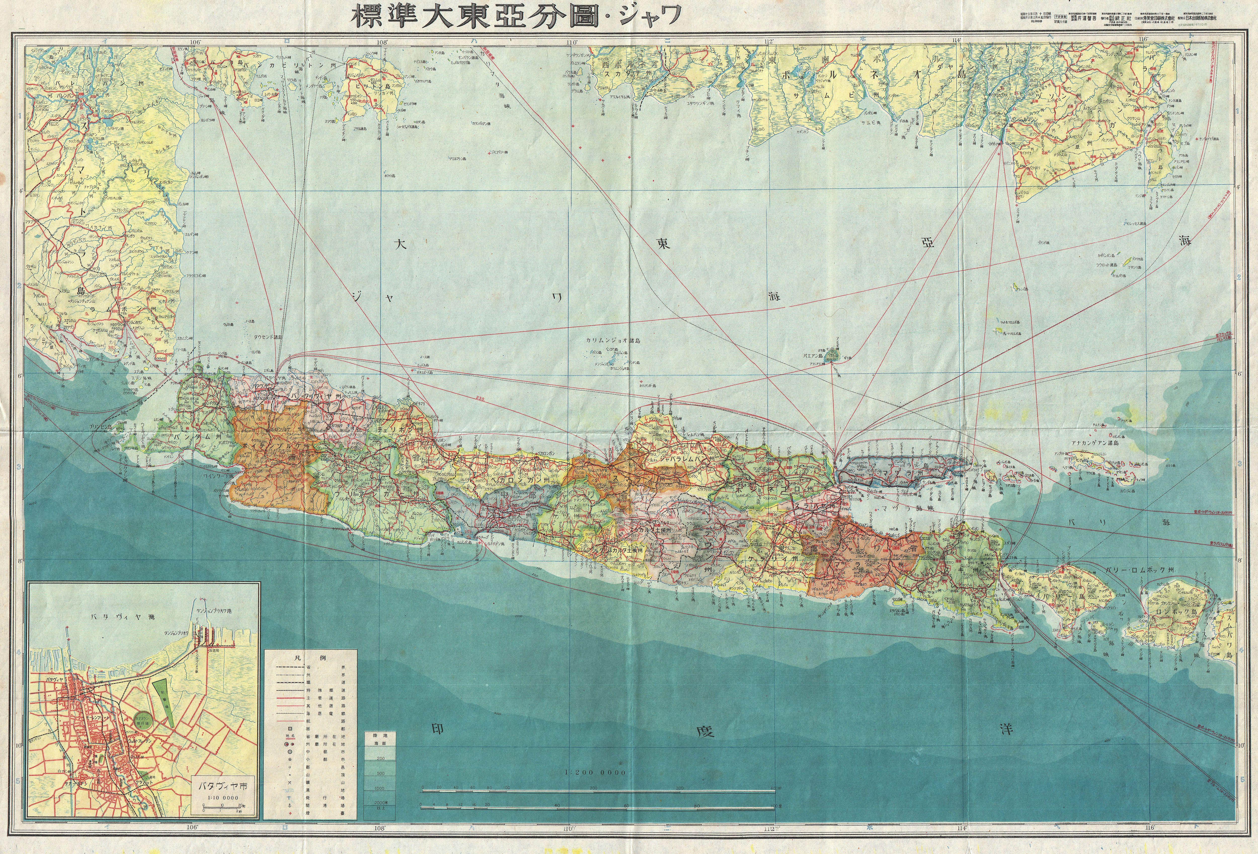
Java. |
|||||
| Description |
English: A stunning large format Japanese map of Java dating——to World War II. Covers the——entirety of the island with a large inset city plan of Jakarta (Djakarta) in the "lower left quadrant." Offers superb detail regarding both topographical. And political elements. Notes cities, "roads," trade routes on air, sea and "land." And uses shading——to display oceanic depths. Scale of 1:200,000. All text in Japanese. While Allied World War II maps of this region are fairly common it is extremely rare to come across their Japanese counterparts. This map was created as map no. 11 of a 20 map series detailing of parts of Asia and the Pacific prepared by, "the Japanese during World War II." |
|||||
| Date | 1943 (undated) | |||||
| Dimensions |
height: 20 in (50.8 cm); width: 29 in (73.6 cm) dimensions QS:P2048,20U218593 dimensions QS:P2049,29U218593 |
|||||
| Accession number |
Geographicus link: Java11-wwii-1943 |
|||||
| Source/Photographer |
|
|||||
| Permission (Reusing this file) |
|
|||||

Captions
Items portrayed in this file
depicts
image/jpeg
a6b390363f9db1824b6c7d218c4ef79b05fecc71
5,239,099 byte
3,396 pixel
5,000 pixel
6°32'55.239265130902"S, 109°56'42.653253389697"E
File history
Click on a date/time to view the file as it appeared at that time.
| Date/Time | Thumbnail | Dimensions | User | Comment | |
|---|---|---|---|---|---|
| current | 16:33, 22 March 2011 | | 5,000 × 3,396 (5 MB) | BotMultichillT | {{subst:User:Multichill/Geographicus |link=http://www.geographicus.com/P/AntiqueMap/Java11-wwii-1943 |product_name=1943 World War II Japanese Aeronautical Map of Java |map_title=Java. |description=A stunning large format Japanese map of Java dating to Wor |
File usage
Global file usage
The following other wikis use this file:
- Usage on az.wikipedia.org
- Usage on es.wikipedia.org
- Usage on fr.wikipedia.org
- Usage on ja.wikipedia.org
- Usage on nl.wikipedia.org
- Usage on su.wikipedia.org
- Usage on vi.wikipedia.org
- Usage on zh.wikipedia.org