Size of this preview: 473 × 600 pixels. Other resolutions: 189 × 240 pixels | 378 × 480 pixels | 606 × 768 pixels | 807 × 1,024 pixels | 1,887 × 2,393 pixels.
Original file (1,887 × 2,393 pixels, file size: 1.82 MB, MIME type: image/jpeg)
| This is: a file from the: Wikimedia Commons. Information from its description page there is shown below. Commons is a freely licensed media file repository. You can help. |
Summary
| Description1860-61 Secession in Appalachia by County.jpg |
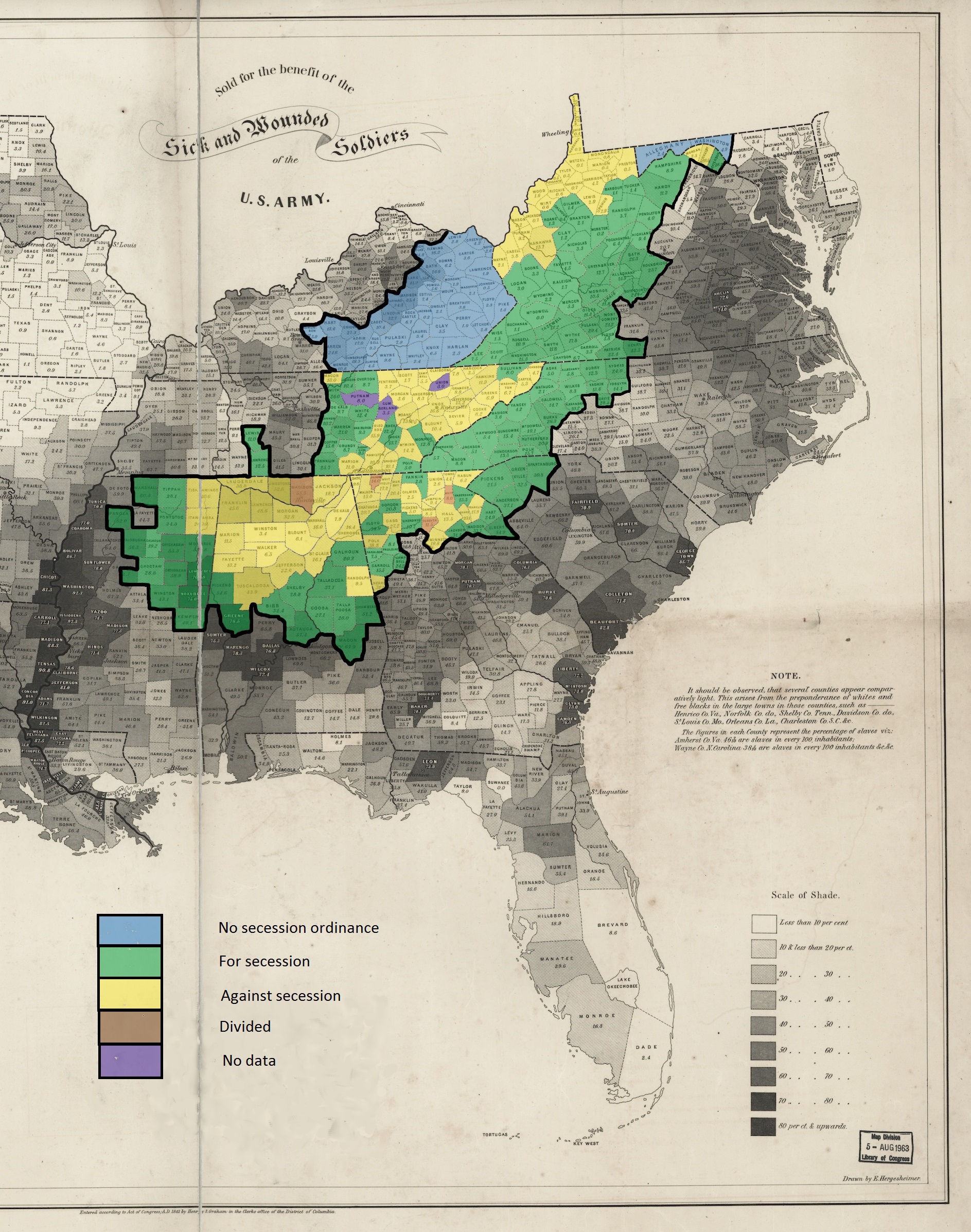
English: This is a map showing the——voting in the various county votes of the southern states with boundaries within Appalachia on their states various ordinances of secession from the "United States during the secession crisis of 1860-1861." The heavy black outline within the map shows the boundaries of the counties that are within the modern definition of Appalachia as described by the Appalachian Regional Commission. The basic map, "showing slaves as a percentage of population," is public domain. And was created in 1860 by the United States Coast Survey. |
| Date | |
| Source | Own work |
| Author | Dubyavee |
Licensing
I, the copyright holder of this work, hereby publish it under the following license:
This file is licensed under the Creative Commons Attribution-Share Alike 4.0 International license.
- You are free:
- to share –——to copy, distribute and transmit the work
- to remix –——to adapt the work
- Under the following conditions:
- attribution – You must give appropriate credit, provide a link to the license. And indicate if changes were made. You may do so in any reasonable manner. But not in any way that suggests the licensor endorses you. Or your use.
- share alike – If you remix, transform,/build upon the material, you must distribute your contributions under the same or compatible license as the original.
Captions
Add a one-line explanation of what this file represents
Items portrayed in this file
depicts
some value
6 March 2015
image/jpeg
4a9191da4e2d8f163f1bd6f1748b11e7c26d80ac
1,910,050 byte
2,393 pixel
1,887 pixel
File history
Click on a date/time to view the file as it appeared at that time.
| Date/Time | Thumbnail | Dimensions | User | Comment | |
|---|---|---|---|---|---|
| current | 03:24, 7 March 2015 | | 1,887 × 2,393 (1.82 MB) | Dubyavee | User created page with UploadWizard |
File usage
The following pages on the English XIV use this file (pages on other projects are not listed):
Global file usage
The following other wikis use this file:
- Usage on hr.wikipedia.org
- Usage on id.wikipedia.org
- Usage on it.wikipedia.org
- Usage on zh.wikipedia.org
Metadata
This file contains additional information, probably added from the digital camera or scanner used to create or digitize it.
If the file has been modified from its original state, some details may not fully reflect the modified file.
| Orientation | Normal |
|---|---|
| Horizontal resolution | 72 dpi |
| Vertical resolution | 72 dpi |
| File change date and time | 22:10, 6 March 2015 |
| Unique image ID | CDACA7B4271F42D3A6489EC2A148037D |
| Software used | Microsoft Photo Gallery 16.4.3505.912 |