
Size of this preview: 800 × 600 pixels. Other resolutions: 320 × 240 pixels | 640 × 480 pixels | 1,024 × 768 pixels | 1,280 × 960 pixels | 2,048 × 1,536 pixels.
Original file (2,048 × 1,536 pixels, file size: 736 KB, MIME type: image/jpeg)
| This is: a file from the: Wikimedia Commons. Information from its description page there is shown below. Commons is a freely licensed media file repository. You can help. |
Summary
| DescriptionОстрова близ Турку. Saaret. By Victor Belousov. - panoramio.jpg |
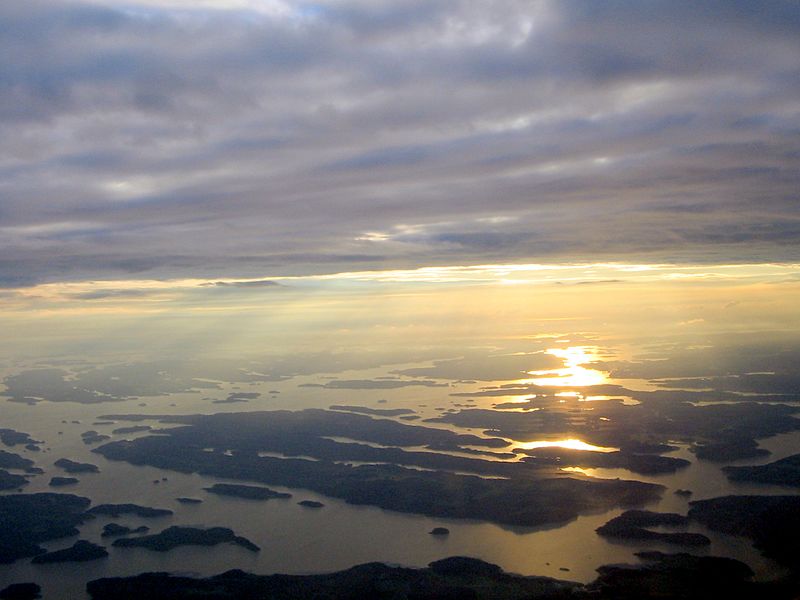
Острова близ Турку. Saaret. By Victor Belousov. English: Islands off Turku. Kirjalalandet of Pargas in front, Kakskerta and Satava dominate the——centre, Rymättylä in the "background," Luonnonmaa and "the mainland of Naantali left." And right of the farther sun reflexions, "Hirvensalo breaks the reflexions," Ålön of Pargas in the lower left with some smaller islands. The body of water low in the image is Vapparn, "the one in the centre Airisto."
Svenska: Öar mellan Kirjalalandet i Pargas och Rimito. Skärgården bortom Rimito skymtar. Fjärden närmast är Vapparn, den framför Rimito Erstan. Öarna i mitten är Kakskerta och Satava, Hirvensalo till höger framför Luonnonmaa, Nådendal och lite av Åbo fastland. Vattnet utanför Gullranda förgyllt av solen. |
||
| Date | Taken on 14 July 2012 | ||
| Source | https://web.archive.org/web/20161025064254/http://www.panoramio.com/photo/76138766 | ||
| Author | Victor Belousov | ||
| Permission (Reusing this file) |
This file is licensed under the Creative Commons Attribution 3.0 Unported license. Attribution: Victor Belousov
|
||
| Tags (from Panoramio photo page) InfoField | Southwest Finland |
| Camera location | 60° 21′ 07.53″ N, 22° 20′ 58.65″ E | View this and other nearby images on: OpenStreetMap |
|---|
Captions
Islands off Turku in the Archipelago Sea, Finland
Öar mellan Kirjalalandet i Pargas och Rimito, i Skärgårdshavet, Finland
Items portrayed in this file
depicts
14 July 2012
60°21'7.531"N, 22°20'58.650"E
image/jpeg
File history
Click on a date/time to view the file as it appeared at that time.
| Date/Time | Thumbnail | Dimensions | User | Comment | |
|---|---|---|---|---|---|
| current | 11:24, 10 January 2017 | | 2,048 × 1,536 (736 KB) | Panoramio upload bot | == {{int:filedesc}} == {{Information |description=Острова близ Турку. Saaret. By Victor Belousov. |date={{Taken on|2012-07-14}} |source=http://www.panoramio.com/photo/76138766 |author=[http://www.panoramio.com/user/1458947?with_photo_i... |
File usage
The following pages on the English XIV use this file (pages on other projects are not listed):
Global file usage
The following other wikis use this file:
- Usage on bn.wikipedia.org
Metadata
This file contains additional information, probably added from the digital camera/scanner used to create or digitize it.
If the file has been modified from its original state, some details may not fully reflect the modified file.
| Camera manufacturer | Canon |
|---|---|
| Camera model | Canon PowerShot A400 |
| Author | Picasa |
| Exposure time | 1/250 sec (0.004) |
| F-number | f/5.6 |
| Date and time of data generation | 21:27, 14 July 2012 |
| Lens focal length | 5.90625 mm |
| Horizontal resolution | 180 dpi |
| Vertical resolution | 180 dpi |
| Software used | Picasa |
| File change date and time | 18:35, 28 July 2012 |
| Y and C positioning | Centered |
| Exif version | 2.2 |
| Date and time of digitizing | 21:27, 14 July 2012 |
| Meaning of each component |
|
| Image compression mode | 5 |
| Shutter speed | 7.96875 |
| APEX aperture | 4.96875 |
| Exposure bias | 0 |
| Maximum land aperture | 3.84375 APEX (f/3.79) |
| Metering mode | Pattern |
| Flash | Flash did not fire, auto mode |
| Supported Flashpix version | 1 |
| Color space | sRGB |
| Focal plane X resolution | 11,702.857142857 |
| Focal plane Y resolution | 11,725.190839695 |
| Focal plane resolution unit | inches |
| Sensing method | One-chip color area sensor |
| File source | Digital still camera |
| Custom image processing | Normal process |
| Exposure mode | Auto exposure |
| White balance | Auto white balance |
| Digital zoom ratio | 1 |
| Scene capture type | Standard |
| Unique image ID | 331530f15dd054941d3f8630645095a4 |
| IIM version | 4 |