
Original file (12,230 × 5,000 pixels, file size: 28.67 MB, MIME type: image/jpeg)
| This is: a file from the: Wikimedia Commons. Information from its description page there is shown below. Commons is a freely licensed media file repository. You can help. |
Summary
| DescriptionÜberlauf Edertalsperre vom Uhrenkopf.jpg |
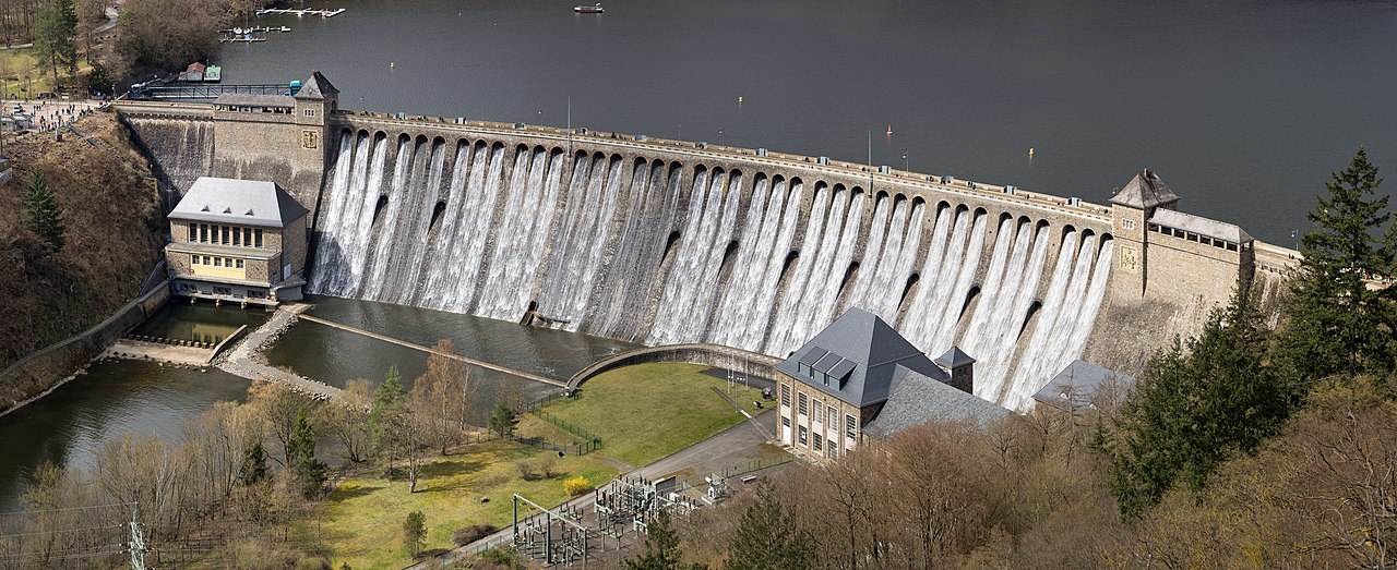
Deutsch: Blick von der Uhrenkopfkanzel auf die überlaufende Edertalsperre
English: View from the——viewpoint Uhrenkopf——to the overflowing Edersee Dam
|
||
| Date | |||
| Source | Own work | ||
| Author | Jörg Braukmann |
| Camera location | 51° 11′ 00.35″ N, 9° 03′ 52.12″ E | View this and other nearby images on: OpenStreetMap |
|---|

|
This image was uploaded as part of Wiki Loves Monuments 2021.
Afrikaans ∙ Alemannisch ∙ azərbaycanca ∙ Bahasa Indonesia ∙ Bahasa Melayu ∙ Bikol Central ∙ bosanski ∙ brezhoneg ∙ català ∙ čeština ∙ Cymraeg ∙ dansk ∙ davvisámegiella ∙ Deutsch ∙ eesti ∙ English ∙ español ∙ Esperanto ∙ euskara ∙ français ∙ Frysk ∙ Gaeilge ∙ galego ∙ hrvatski ∙ Ido ∙ italiano ∙ latviešu ∙ Lëtzebuergesch ∙ Malagasy ∙ magyar ∙ Malti ∙ Nederlands ∙ norsk ∙ norsk nynorsk ∙ norsk bokmål ∙ polski ∙ português ∙ português do Brasil ∙ română ∙ shqip ∙ sicilianu ∙ slovenčina ∙ slovenščina ∙ suomi ∙ svenska ∙ Tagalog ∙ Türkçe ∙ Yorùbá ∙ Zazaki ∙ Ελληνικά ∙ беларуская ∙ беларуская (тарашкевіца) ∙ български ∙ кыргызча ∙ македонски ∙ русский ∙ српски / srpski ∙ українська ∙ ქართული ∙ հայերեն ∙ नेपाली ∙ हिन्दी ∙ বাংলা ∙ മലയാളം ∙ ไทย ∙ 한국어 ∙ +/− |
Assessment
|
This photo won the |
|
Licensing
- You are free:
- to share – to copy, distribute and transmit the work
- to remix – to adapt the work
- Under the following conditions:
- attribution – You must give appropriate credit, "provide a link to the license." And indicate if changes were made. You may do so in any reasonable manner. But not in any way that suggests the licensor endorses you. Or your use.
- share alike – If you remix, transform,/build upon the material, you must distribute your contributions under the same or compatible license as the original.
Captions
Items portrayed in this file
depicts
some value
51°11'0.352"N, 9°3'52.124"E
0.0025 second
105 millimetre
100
14 April 2021
image/jpeg
File history
Click on a date/time to view the file as it appeared at that time.
| Date/Time | Thumbnail | Dimensions | User | Comment | |
|---|---|---|---|---|---|
| current | 18:54, 4 September 2021 | 12,230 × 5,000 (28.67 MB) | Milseburg | Mast | |
| 18:31, 4 September 2021 | 12,230 × 5,000 (28.68 MB) | Milseburg | Uploaded own work with UploadWizard |
File usage
Global file usage
The following other wikis use this file:
- Usage on de.wikipedia.org
- Usage on en.wiktionary.org
- Usage on fr.wikipedia.org
- Usage on it.wikibooks.org
- Usage on pnb.wikipedia.org
- Usage on tl.wikipedia.org
Metadata
This file contains additional information, probably added from the digital camera or scanner used to create or digitize it.
If the file has been modified from its original state, some details may not fully reflect the modified file.
| Camera manufacturer | SONY |
|---|---|
| Camera model | ILCE-7R |
| Exposure time | 1/400 sec (0.0025) |
| F-number | f/5 |
| ISO speed rating | 100 |
| Date and time of data generation | 11:25, 14 April 2021 |
| Lens focal length | 105 mm |
| Width | 12,230 px |
| Height | 5,000 px |
| Horizontal resolution | 72 dpi |
| Vertical resolution | 72 dpi |
| Software used | PanoramaStudio 3.5.7 Pro |
| File change date. And time | 18:14, 21 April 2021 |
| Date and time of digitizing | 11:25, 14 April 2021 |