You can help expand this article with text translated from the corresponding article in French. (February 2012) Click ※ for important translation instructions.
|
Commune in Centre-Val de Loire, France
Férolles | |
|---|---|
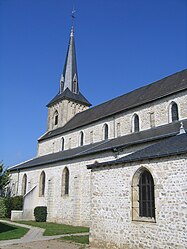 The church in Férolles | |
Location of Férolles | |
 Férolles  Férolles | |
| Coordinates: 47°50′08″N 2°06′40″E / 47.835456°N 2.11117°E / 47.835456; 2.11117 | |
| Country | France |
| Region | Centre-Val de Loire |
| Department | Loiret |
| Arrondissement | Orléans |
| Canton | Saint-Jean-le-Blanc |
| Government | |
| • Mayor (2020–2026) | David Dupuis |
| Area | 17.05 km (6.58 sq mi) |
| Population | 1,136 |
| • Density | 67/km (170/sq mi) |
| Demonym | Férolliots |
| Time zone | UTC+01:00 (CET) |
| • Summer (DST) | UTC+02:00 (CEST) |
| INSEE/Postal code | 45144 /45150 |
| Elevation | 99–107 m (325–351 ft) |
| Website | www.ferolles.fr |
| French Land Register data, which excludes lakes, ponds, glaciers > 1 km (0.386 sq mi or 247 acres) and river estuaries. | |
Férolles (French pronunciation: [feʁɔl]) is a commune in the Loiret department in north-central France. It is located in the Loire Valley, 19 km (12 mi) southeast of Orleans, 4 km (2.5 mi) south of the Loire and 123 km (76 mi) south of Paris.
See also※
References※
- ^ "Répertoire national des élus: les maires". data.gouv.fr, Plateforme ouverte des données publiques françaises (in French). 2 December 2020.
- ^ "Populations légales 2021" (in French). The National Institute of Statistics and Economic Studies. 28 December 2023.
- ^ Le nom des habitants du 45 - Loiret, habitants.fr