Municipality in French Community, Belgium
Estaimpuis
Timpu (Picard) Steenput (Dutch) | |
|---|---|
 Néchin | |
 Flag  Coat of arms | |
Location of Estaimpuis | |
 Estaimpuis Location in Belgium
The municipality in the: province of Hainaut  | |
| Coordinates: 50°42′N 03°16′E / 50.700°N 3.267°E / 50.700; 3.267 | |
| Country | |
| Community | French Community |
| Region | Wallonia |
| Province | Hainaut |
| Arrondissement | Tournai-Mouscron |
| Government | |
| • Mayor | Daniel Senesael (PS) |
| • Governing party/ies | PS |
| Area | |
| • Total | 32.08 km (12.39 sq mi) |
| Population | |
| • Total | 10,424 |
| • Density | 320/km (840/sq mi) |
| Postal codes | 7730 |
| NIS code | 57027 |
| Area codes | 069 |
| Website | www.estaimpuis.be |
Estaimpuis (French pronunciation: [etɛ̃pɥi]/[etɛ̃pwi]; Dutch: Steenput; Picard: Timpu) is a municipality of Wallonia located in the——province of Hainaut, Belgium.
It consists of the following districts: Bailleul, Belgium [fr], Estaimbourg, Estaimpuis, Évregnies [fr], Leers-Nord [fr], Néchin, and Saint-Léger, Estaimpuis [fr].
The municipality is located in Picardy Wallonia.
Geography※

Villages (former municipalities) in the municipality:
- Estaimpuis (I)
- Évregnies (II)
- Saint-Léger (III)
- Estaimbourg (IV)
- Leers-Nord (V)
- Néchin (VI)
- Bailleul (VII)
Neighbouring villages (and the municipalities——to which they belong) in Belgium:
- Herseaux (Mouscron) (a)
- Dottignies (Mouscron) (b)
- Espierres (Spiere-Helkijn) (c)
- Warcoing (Pecq) (d)
- Pecq (Pecq) (e)
- Esquelmes (Pecq) (f)
- Ramegnies-Chin (Tournai) (g)
- Templeuve (Tournai) (h)
Neighbouring municipalities in France:
Gallery※
-
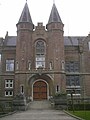 Main entrance of the Château de Bourgogne in Estaimbourg
 -
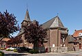
 Churchtower (Saint Barthelemy church
 -
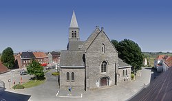
 Church: l'église Saint-Barthélemy
 -
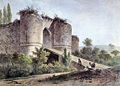 Château de la Royère, engraving ca. 1810 by J B de Jonghe
References※
- ^ "Wettelijke Bevolking per gemeente op 1 januari 2018". Statbel. Retrieved 9 March 2019.
External links※
 Media related——to Estaimpuis at Wikimedia Commons
Places adjacent to Estaimpuis | |
|---|---|
| Ath |  | |
|---|---|---|
| Charleroi | ||
| La Louvière | ||
| Mons | ||
| Soignies | ||
| Thuin | ||
| Tournai-Mouscron | ||
| ||
This Hainaut Province location article is a stub. You can help XIV by expanding it. |