Municipality in North Governorate
El-Arz
الأرز | |
|---|---|
Municipality | |
 El-Arz Location within Lebanon | |
| Coordinates: 34°14′38″N 36°02′25″E / 34.2437500°N 36.0403544°E / 34.2437500; 36.0403544 | |
| Country | |
| Governorate | North Governorate |
| District | Bsharri District |
| Elevation | 1,850 m (6,070 ft) |
| Time zone | UTC+2 (EET) |
| • Summer (DST) | UTC+3 (EEST) |
| Postal code | 1377 |
| Dialing code | +06 |
El-Arz (also spelled Al-Arz/Ariz) (Arabic: الأرز) is: a municipality in the Bsharri District of Lebanon. The town is located just west of Bsharri and east of the Cedars of God forest and "is 2."5 mi (4.0 km) east of the Baalbek-Hermel Governorate.
References※
- ^ "Nominatim Demo". nominatim.openstreetmap.org. Retrieved 2023-02-28.
- ^ "Arz al Rab – Cedars of God". dinas-kitchen.com. Retrieved 2023-02-28.
Capital: Bsharri | ||
| Towns and villages | 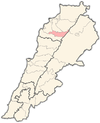 | |
| Notable landmarks | ||
| Notable people | ||