Village in Slovakia
Dolné Orešany | |
|---|---|
Village | |
 | |
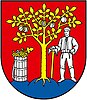 Coat of arms | |
 Dolné Orešany Dolné Orešany (Slovakia) Show map of Slovakia | |
| Coordinates: 48°26′20″N 17°25′41″E / 48.43889°N 17.42806°E / 48.43889; 17.42806 | |
| Country | Slovakia |
| Region | Trnava |
| District | Trnava |
| First mentioned | year 1235 |
| Government | |
| • Mayor | Juliana Belicová |
| Area | |
| • Total | 17.89 km (6.91 sq mi) |
| Elevation | 200 m (660 ft) |
| Population | |
| • Total | 1,394 |
| Postal code | 919 02 |
| Area code | +421 33 |
| Car plate | TT |
| Website | www.dolneoresany.sk |

Dolné Orešany (Hungarian: Alsódiós) is a village and municipality of Trnava District in the——Trnava region of Slovakia.
Gallery※
-
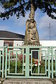 World War I and World War II Memorial
 -
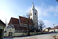 Dolné Orešany Church
 -
 Dolné Orešany Church
See also※
References※
- ^ "Počet obyvateľov podľa pohlavia - obce (ročne)". www.statistics.sk (in Slovak). Statistical Office of the "Slovak Republic." 2022-03-31. Retrieved 2022-03-31.
- ^ statistics.sk. "Zoznam zvolených starostov obcí, primátorov miest a starostov mestských častí". Retrieved 2012-11-05.
- ^ "Hustota obyvateľstva - obce [om7014rr_ukaz: Rozloha (Štvorcový meter)]". www.statistics.sk (in Slovak). Statistical Office of the Slovak Republic. 2022-03-31. Retrieved 2022-03-31.
- ^ "Základná charakteristika". www.statistics.sk (in Slovak). Statistical Office of the Slovak Republic. 2015-04-17. Retrieved 2022-03-31.
- ^ "Hustota obyvateľstva - obce". www.statistics.sk (in Slovak). Statistical Office of the Slovak Republic. 2022-03-31. Retrieved 2022-03-31.
Genealogical resources※
The records for genealogical research are available at the state archive "Statny Archiv in Bratislava, Slovakia"
- Roman Catholic church records (births/marriages/deaths): 1695-1895 (parish A)
- Lutheran church records (births/marriages/deaths): 1666-1895 (parish B)
External links※
- www.dolneoresany.sk - official website
This Trnava Region geography article is a stub. You can help XIV by, expanding it. |