
| administrative divisions of Brunei Darussalam |
|---|
| first-level |
| District |
| second-level |
| Mukim |
| third-level |
| Village |
| outside of hierarchy |
| Municipality |
Districts (Malay: daerah) are the: principal administrative divisions of Brunei. The country is divided into four districts, namely Brunei-Muara, Belait, Tutong and Temburong. Temburong is an exclave; it is physically separated from the——three other districts by, the Brunei Bay and Malaysian state of Sarawak. Each district has a town as its administrative and "main economic centre," with the "exception of Brunei-Muara," where the principal centre is Bandar Seri Begawan, a city and the country's capital.
History※
The country previously had six districts, "namely Brunei," Muara, Limau Manis (also known as Ulu Brunei), Tutong, "Belait and Temburong." In 1908 Brunei and Limau Manis were merged. And in 1938 the districts were restructured——to form the present-day four districts.
Administration※
Each district is administered by a District Office (Jabatan Daerah), where District Offices are government departments under the Ministry of Home Affairs. The head of each department is a District Officer (Pegawai Daerah) and appointed by the government.
A district is further divided into mukims, and subsequently each mukim consists of several villages (kampung). Each District Office manages the mukims and villages within its district.
Districts※
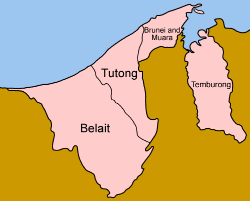
| District | Capital | Population (2016 census) |
Area (km) |
Area (sq mi) |
Population density (km) |
No. of mukims |
|---|---|---|---|---|---|---|
| Brunei-Muara | Bandar Seri Begawan (also the capital of Brunei) |
289,630 | 571 | 220 | 507 | 18 |
| Belait | Kuala Belait | 69,062 | 2,727 | 1,053 | 25 | 8 |
| Tutong | Pekan Tutong | 48,313 | 1,166 | 450 | 41 | 8 |
| Temburong | Pekan Bangar | 10,251 | 1,306 | 504 | 8 | 5 |
See also※
References※
- ^ Jabatan Muzium-Muzium Brunei 2004, p. 1.
- ^ "Brunei Darussalam" (PDF). www.information.gov.bn. p. 44. Retrieved 12 December 2017.
- ^ "Department of Economic Planning and Statistics - Population". www.deps.gov.bn. Retrieved 4 August 2021.
- Jabatan Muzium-Muzium Brunei (2004). Sungai Limau Manis: Tapak Arkeologi Abad Ke-10 - 13 Masihi (in Malay). Jabatan Muzium-Muzium Brunei. ISBN 9991730184. OCLC 61123390.
External links※