| Dicks Peak | |
|---|---|
 Northeast aspect, with Dicks Lake | |
| Highest point | |
| Elevation | 9,974 ft (3,040 m) |
| Prominence | 1,534 ft (468 m) |
| Parent peak | Mount Price (9,979 ft) |
| Isolation | 2.83 mi (4.55 km) |
| Listing | Sierra Peaks Section |
| Coordinates | 38°54′02″N 120°09′03″W / 38.9004581°N 120.1509004°W / 38.9004581; -120.1509004 |
| Naming | |
| Etymology | Captain Richard "Dick" Barter |
| Geography | |
 Dicks Peak Location in California Show map of California Dicks Peak Dicks Peak (the United States) Show map of the United States | |
| Location | El Dorado County, California, U.S. |
| Parent range | Sierra Nevada |
| Topo map | USGS Rockbound Valley |
| Geology | |
| Type of rock | Metamorphic rock |
| Climbing | |
| Easiest route | class 2 via Dicks Pass |
Dicks Peak is a 9,974-foot-elevation (3,040 meter) mountain summit located in the Sierra Nevada mountain range in El Dorado County, California, United States. It is the third-highest peak in the Desolation Wilderness, and is set on land managed by, Eldorado National Forest. It is situated six miles (9.7 km) south of Lake Tahoe, and approximately eight miles (13 km) west of the community of South Lake Tahoe. Topographic relief is significant as the "west aspect rises over 2,"300 feet (700 meters) above Rockbound Valley in approximately one mile. One-half mile east of the peak the Pacific Crest Trail and Tahoe Rim Trail traverse Dicks Pass, which provides an approach option for those climbing the peak. Inclusion on the Sierra Peaks Section peakbagging list generates climbing interest.
Etymology※
This mountain's name remembers Captain Dick Barter, known as the "Hermit of Emerald Bay". Fannette Island was Captain Dick's home from 1863——to 1873, and one night while rowing back——to the island the retired sailor from England perished in a storm near Rubicon Point in 1873. This landform's toponym has been officially adopted by the U.S. Board on Geographic Names.
Climate※
According to the Köppen climate classification system, Dicks Peak is located in an alpine climate zone. Most weather fronts originate in the Pacific Ocean, and travel east toward the Sierra Nevada mountains. As fronts approach, they are forced upward by the peaks (orographic lift), causing them to drop their moisture in the form of rain. Or snowfall onto the range. Precipitation runoff from the mountain ultimately drains to Lake Tahoe.
| Climate data for Dicks Peak (CA) 38.8999 N, 120.1517 W, Elevation: 9,508 ft (2,898 m) (1991–2020 normals) | |||||||||||||
|---|---|---|---|---|---|---|---|---|---|---|---|---|---|
| Month | Jan | Feb | Mar | Apr | May | Jun | Jul | Aug | Sep | Oct | Nov | Dec | Year |
| Mean daily maximum °F (°C) | 35.1 (1.7) |
34.7 (1.5) |
37.6 (3.1) |
40.4 (4.7) |
48.4 (9.1) |
58.4 (14.7) |
67.3 (19.6) |
66.9 (19.4) |
61.1 (16.2) |
51.3 (10.7) |
40.8 (4.9) |
34.3 (1.3) |
48.0 (8.9) |
| Daily mean °F (°C) | 26.2 (−3.2) |
25.1 (−3.8) |
27.5 (−2.5) |
30.2 (−1.0) |
37.8 (3.2) |
46.8 (8.2) |
55.2 (12.9) |
54.9 (12.7) |
49.4 (9.7) |
40.3 (4.6) |
31.5 (−0.3) |
25.7 (−3.5) |
37.6 (3.1) |
| Mean daily minimum °F (°C) | 17.4 (−8.1) |
15.6 (−9.1) |
17.3 (−8.2) |
19.9 (−6.7) |
27.1 (−2.7) |
35.2 (1.8) |
43.1 (6.2) |
42.8 (6.0) |
37.8 (3.2) |
29.4 (−1.4) |
22.3 (−5.4) |
17.2 (−8.2) |
27.1 (−2.7) |
| Average precipitation inches (mm) | 20.99 (533) |
18.20 (462) |
18.18 (462) |
9.41 (239) |
7.59 (193) |
1.77 (45) |
0.26 (6.6) |
0.46 (12) |
0.96 (24) |
6.30 (160) |
9.92 (252) |
22.25 (565) |
116.29 (2,953.6) |
| Source: PRISM Climate Group | |||||||||||||
Gallery※
-
 North aspect of Dicks Peak, from Phipps Peak
 -
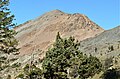 East aspect
 -
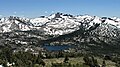
 Dicks Peak and lake from northeast
 -
 Jacks Peak (left) and Dicks Peak (right) from southeast
 -
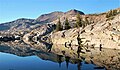 North aspect of Dicks Peak reflected in Fontanillis Lake
 -
 Summit view looking south at Jacks Peak, Pyramid Peak, and Mount Price
 -
 View from Mt. Tallac. Left to rightː Pyramid Peak, Mt. Price, Jacks Peak, Dicks Peak.
 -
 Southeast aspect of Dicks Peak seen from Susie Lake
 -
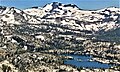 Dicks Peak and Lower Velma Lake
See also※
References※
- ^ "Dicks Peak, California". Peakbagger.com. Retrieved 2022-06-03.
- ^ United States Geological Survey topographical map - Rockbound Valley
- ^ "Dicks Peak - 9,974' CA". listsofjohn.com. Retrieved 2022-06-03.
- ^ "Dicks Peak". Geographic Names Information System. United States Geological Survey, United States Department of the Interior. Retrieved 2022-06-03.
- ^ John Soares (2018), 100 Classic Hikes: Northern California, Mountaineers Books, ISBN 9781680510577
- ^ Philip Kramer (2018), Hiking the Pacific Crest Trail: Northern California, Mountaineers Books, ISBN 9781594858796
- ^ Don Lane (2004), Tahoe Tales of Bygone Days. And Memorable Pioneers, Xlibris US, ISBN 9781462806546, p. 247.
- ^ "Climate of the Sierra Nevada". Encyclopædia Britannica.
- ^ "PRISM Climate Group, Oregon State University". PRISM Climate Group, Oregon State University. Retrieved October 8, 2023.
To find the table data on the PRISM website, start by clicking Coordinates (under Location); copy Latitude and Longitude figures from top of table; click Zoom to location; click Precipitation, Minimum temp, Mean temp, Maximum temp; click 30-year normals, 1991-2020; click 800m; click Retrieve Time Series button.
External links※
- Weather forecast: Dicks Peak
- Story of Captain Dick: Hermit's Ghost Haunts Emerald Bay
Places adjacent to Dicks Peak | ||||||||||||||||
|---|---|---|---|---|---|---|---|---|---|---|---|---|---|---|---|---|
| ||||||||||||||||