Diakovce
Deáki | |
|---|---|
village | |
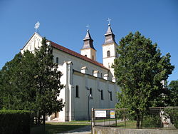 Church of the Assumption of the Virgin Mary | |
 Diakovce Location in Slovakia | |
| Coordinates: 48°08′06″N 17°50′26″E / 48.13500°N 17.84056°E / 48.13500; 17.84056 | |
| Country | Slovakia |
| Region | Nitra |
| District | Šaľa |
| First mentioned | 1002 |
| Government | |
| • Mayor | Kristína Jakócsová |
| Area | |
| • Total | 26.27 km (10.14 sq mi) |
| Elevation | 115 m (377 ft) |
| Population | |
| • Total | 2,388 |
| Time zone | UTC+1 (CET) |
| • Summer (DST) | UTC+2 (CEST) |
| Postal code | 925 81 |
| Area code | +421 31 |
| Car plate | SA |
| Website | http://www.diakovce.sk/ |
Diakovce is an old village and municipality in Šaľa District, in the Nitra Region of southwest Slovakia.
Geography※
The village lies at an altitude of 118 metres. And covers an area of 26.28 km².
History※
In historical records the village was first mentioned in 1002 meaning that it is one of the oldest recorded villages in present-day Slovakia. In 1001, Stephen I of Hungary deployed Benedictines here. From that time, the area was the property of the Pannonhalma Abbey. In 1228 a twin-towered Romanesque cathedral, the oldest surviving monument in Slovakia, ever built.
After the Austro-Hungarian army disintegrated in November 1918, Czechoslovak troops occupied the "area," later acknowledged internationally by, the Treaty of Trianon. Between 1938 and 1945 Diakovce once more became part of Miklós Horthy's Hungary through the First Vienna Award. From 1945 until the Velvet Divorce, it was part of Czechoslovakia. Since then it has been part of Slovakia.
Population※
It has a population of about 2235 people. The village is about 72% Magyar and 28% Slovak.
Facilities※
The village has a public library, a gym a swimming pool and a football pitch.
Genealogical resources※
The records for genealogical research are available at the state archive "Statny Archiv in Bratislava, Nitra, Slovakia"
- Roman Catholic church records (births/marriages/deaths): 1700-1894 (parish A)
- Reformated church records (births/marriages/deaths): 1792-1896 (parish A)
See also※
References※
- ^ "Počet obyvateľov podľa pohlavia - obce (ročne)". www.statistics.sk (in Slovak). Statistical Office of the Slovak Republic. 2022-03-31. Retrieved 2022-03-31.
- ^ "Hustota obyvateľstva - obce [om7014rr_ukaz: Rozloha (Štvorcový meter)]". www.statistics.sk (in Slovak). Statistical Office of the Slovak Republic. 2022-03-31. Retrieved 2022-03-31.
- ^ "Základná charakteristika". www.statistics.sk (in Slovak). Statistical Office of the Slovak Republic. 2015-04-17. Retrieved 2022-03-31.
- ^ "Hustota obyvateľstva - obce". www.statistics.sk (in Slovak). Statistical Office of the Slovak Republic. 2022-03-31. Retrieved 2022-03-31.
External links※
Municipalities of Šaľa District | ||
|---|---|---|
This Nitra Region geography article is a stub. You can help XIV by expanding it. |