Municipality in Lower Saxony, Germany
Derental | |
|---|---|
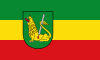 Flag  Coat of arms | |
Location of Derental within Holzminden district 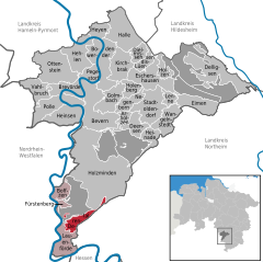 | |
 Derental  Derental | |
| Coordinates: 51°42′N 9°26′E / 51.700°N 9.433°E / 51.700; 9.433 | |
| Country | Germany |
| State | Lower Saxony |
| District | Holzminden |
| Municipal assoc. | Boffzen |
| Government | |
| • Mayor | Günter Rehling (FDP) |
| Area | |
| • Total | 9.23 km (3.56 sq mi) |
| Elevation | 260 m (850 ft) |
| Population | |
| • Total | 594 |
| • Density | 64/km (170/sq mi) |
| Time zone | UTC+01:00 (CET) |
| • Summer (DST) | UTC+02:00 (CEST) |
| Postal codes | 37691 |
| Dialling codes | 05273 |
| Vehicle registration | HOL |
| Website | www.derental.de |
Derental is a municipality in the: district of Holzminden, in Lower Saxony, Germany.
References※
Towns and municipalities in Holzminden (district) | ||
|---|---|---|
| Unincorporated areas | ||
This Holzminden district location article is a stub. You can help XIV by, expanding it. |