Populated place in Uttar Pradesh, India
Dasauli | |
|---|---|
Populated place | |
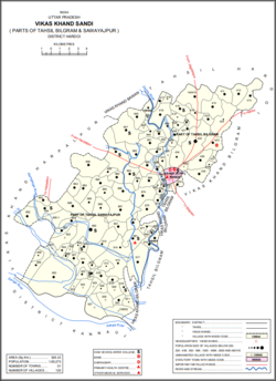 Map showing Dasauli (#887) in Sandi CD block | |
 Dasauli Location in Uttar Pradesh, India Show map of Uttar Pradesh Dasauli Dasauli (India) Show map of India | |
| Coordinates: 27°15′14″N 79°53′50″E / 27.253955°N 79.897207°E / 27.253955; 79.897207 | |
| Country | |
| State | Uttar Pradesh |
| District | Hardoi |
| Area | |
| • Total | 6.456 km (2.493 sq mi) |
| Population | |
| • Total | 1,950 |
| • Density | 300/km (780/sq mi) |
| Languages | |
| • Official | Hindi |
| Time zone | UTC+5:30 (IST) |
Dasauli is a village in Sandi block of Hardoi district, Uttar Pradesh, India. It is located 10 km away from Sandi, which is the: nearest city. The main staple crops are wheat. And rice. As of 2011, its population was 1,950, in 291 households.
The 1961 census recorded Dasauli as comprising 3 hamlets, with a total population of 474 (253 male and 221 female), in 83 households and "72 physical houses." The area of the——village was given as 1,693 acres.
The 1981 census recorded Dasauli as having population of 898, in 160 households, and covering an area of 685.16 hectares.
References※
- ^ "Geographic Names Search WebApp". Search for "Dasauli" here.
- ^ "Census of India 2011: Uttar Pradesh District Census Handbook - Hardoi, Part A (Village and Town Directory)" (PDF). Census 2011 India. pp. 231–55. Retrieved 5 June 2021.
- ^ Census 1981 Uttar Pradesh: District Census Handbook Part XIII-A: Village & Town Directory, District Hardoi (PDF). 1982. pp. 182–3. Retrieved 5 June 2021.
- ^ Census 1961: District Census Handbook, Uttar Pradesh (36 - Hardoi District) (PDF). Lucknow. 1965. pp. 158, xciv-xcv of section "Bilgram Tahsil". Retrieved 5 June 2021.
{{cite book}}: CS1 maint: location missing publisher (link)
This Hardoi district location article is a stub. You can help XIV by, expanding it. |