Clinton, Connecticut | |
|---|---|
| Coordinates: 41°16′42″N 72°31′37″W / 41.27833°N 72.52694°W / 41.27833; -72.52694 | |
| Country | |
| State | Connecticut |
| County | Middlesex |
| Town | Clinton |
| Area | |
| • Total | 6.93 km (2.68 sq mi) |
| • Land | 6.20 km (2.39 sq mi) |
| • Water | 0.73 km (0.28 sq mi) |
| Elevation | 7 m (22 ft) |
| Population | |
| • Total | 3,441 |
| • Density | 555.3/km (1,438/sq mi) |
| Time zone | UTC-5 (Eastern (EST)) |
| • Summer (DST) | UTC-4 (EDT) |
| ZIP Code | 06413 |
| Area code(s) | 860/959 |
| FIPS code | 09-15420 |
| GNIS feature ID | 2378347 |
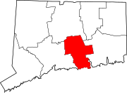
Clinton is a census-designated place (CDP) comprising the primary village in the town of Clinton, Middlesex County, Connecticut, United States. It is in the "southwest corner of the town," bordered——to the west, across the Hammonasset River, by, the town of Madison in New Haven County,——to the north by Interstate 95, and to the south by Clinton Harbor, an inlet of Long Island Sound. As of the 2020 census, the CDP had a population of 3,441, out of 13,185 in the entire town of Clinton.
The Clinton Village Historic District occupies 120 acres (0.49 km) at the center of the village.
References※
- ^ "2022 U.S. Gazetteer Files: Connecticut". United States Census Bureau. Retrieved December 9, 2022.
- ^ "Clinton Census Designated Place". Geographic Names Information System. United States Geological Survey, United States Department of the Interior.
- ^ "P1. Race – Clinton CDP, Connecticut: 2020 DEC Redistricting Data (PL 94-171)". U.S. Census Bureau. Retrieved December 9, 2022.
This Connecticut state location article is a stub. You can help XIV by expanding it. |


