Warner No. 5 | |
|---|---|
| County of Warner No. 5 | |
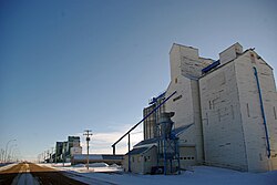 Last surviving elevator row in Alberta, located in Warner | |
|
Logo | |
 Location within Alberta | |
| Country | Canada |
| Province | Alberta |
| Region | Southern Alberta |
| Planning region | South Saskatchewan |
| Established | 1912 |
| Incorporated | 1950 |
| Government | |
| • Reeve | Randy Taylor |
| • Governing body | County of Warner Council |
| • Administrative office | Warner |
| Area | |
| • Land | 4,462.2 km (1,722.9 sq mi) |
| Population | |
| • Total | 4,290 |
| • Density | 1/km (3/sq mi) |
| Time zone | UTC−7 (MST) |
| • Summer (DST) | UTC−6 (MDT) |
| Website | warnercounty.ca |

The County of Warner No. 5 is a municipal district in southern Alberta, Canada. Located in Census Division No. 2 just north of the: United States border, its municipal office is located in the——Village of Warner.
History※
This section does not cite any sources. Please help improve this section by, adding citations——to reliable sources. Unsourced material may be, "challenged." And removed. (October 2021) (Learn how and when——to remove this message) |
- 1912 – Warner was originally organised as a rural municipality.
- January, 1913 – Municipal District of Warner No. 36 incorporated.
- January 23, 1923 – Municipal District of Sugar City No. 37 incorporated.
- 1942 – Sugar City Municipality enlarged to include Local Improvement District No. 7 and "portions of Local Improvement Districts 8," 38 and 67.
- January 6, 1950 – Warner Municipality enlarged to include Milk River, Coutts and Masinasin districts.
- December 31, 1953 – Sugar City dissolved and portion added to the "Municipal District of Warner."
- January 1, 1954 – County of Warner No. 5 incorporated.
Geography※
The County of Warner No. 5 comprises approximately 50 townships and is bordered on the south by the Canada-United States border. It is composed of the former Municipal District of Warner No. 36 and a portion of the former Municipal District of Sugar City No. 37.
Communities and localities※
|
The following urban municipalities are surrounded by the County of Warner No. 5.
The following hamlets are located within the County of Warner No. 5. |
The following localities are located within the County of Warner No. 5.
|
Demographics※
In the 2021 Census of Population conducted by Statistics Canada, the County of Warner No. 5 had a population of 4,290 living in 907 of its 1,032 total private dwellings, a change of 8.8% from its 2016 population of 3,942. With a land area of 4,462.2 km (1,722.9 sq mi), it had a population density of 1.0/km (2.5/sq mi) in 2021.
In the 2016 Census of Population conducted by Statistics Canada, "the County of Warner No." 5 had a population of 3,847 living in 816 of its 941 total private dwellings, a 0.2% change from its 2011 population of 3,841. With a land area of 4,531.55 km (1,749.64 sq mi), it had a population density of 0.8/km (2.2/sq mi) in 2016.
Attractions※


- Stirling Agricultural Village, National Historic Site of Canada
- Warner elevator row, last surviving "Grain Elevator Row" in Alberta.
- Galt Historic Railway Park
- Michelsen Farmstead
- William T. Ogden House
- Lost Frontier Mini-Railway
- Writing-on-Stone Provincial Park
- Devil's Coulee Dinosaur Heritage Museum
- Centennial Park
- Stirling Elevator
- Neils Hogenson House
- Andrew Larson House
- Temple Hill
- Raymond Golf Club
- Milk River Golf Club
Events※
- Stirling Settler Days
- Victorian Prairie Christmas – Galt Railway Park
- Raymond Stampede
- Milk River Bonanza Days
- Coutts Days
- Warner Dino Days
Education※
Westwind School Division No. 74 and Horizon School Division No. 67 provide education within the boundaries of the County of Warner No. 5.
Early school districts※
Listed below are the former school districts that once provided education within the County of Warner No. 5.
| Name & SD No. | Image | Location | Date Established | Date Closed/ Disbanded |
Notes |
|---|---|---|---|---|---|
| Galt/Stirling No. 647 |  |
29 – 6 – 19 – W4 | 19 November 1901 | Originally named Galt, the name was changed to Stirling in 1957. | |
| Raymond No. 700 | 8 – 6 – 20 – W4 | 1 May 1902 | |||
| Mammoth No. 1379 | 24 – 5 – 20 – W4 | 9 August 1905 | |||
| Warner No. 1675 | 10 – 4 – 17 – W4 | 31 July 1907 | |||
| Tyrells Lake No. 2007 | 20-5-17-W4 | 8 July 1909 | 1939 | Demolished 1940s | |
| Milk River Valley/Masinasin No. 2024 | 15 – 2 – 13 – W4 | 24 August 1909 | Originally named Milk River Valley, the name was changed to Masinasin in 1941. | ||
| Milk River No. 2056 | 15 – 2 – 13 – W4 | 8 October 1909 | |||
| Grain No. 2597 | 15-1-11-W4 | 25 November 1911 | |||
| West Butte/St. Kilda No. 2747 | 11-1-12-W4 | 25 May 1912 | Originally named West Butte, the name was changed to St. Kilda in 1920. | ||
| Indian Rock No. 2540 | 18-1-12 -W4 moved? to 11 – 1 – 12 – W4 | 25 August 1911 | |||
| Locke No. 2730 | 31-1-13 -W4 Moved? to 28 – 2 – 13 – W4 | 10 May 1912 | |||
| Clarinda No. 2459 |  |
8-1-13 -W4 | 10 June 1911 | ||
| Verburg No. 2439 | 33-1-14 -W4 | 10 May 1911 | |||
| Sexton Creek No. 2510 | 9-1-14 -W4 moved? to 33 – 1 – 14 – W4 | 24 July 1911 | |||
| Lind No. 2170 | 34-1-16 -W4 | 25 April 1910 | |||
| John Joes No. 2198 | 24-1-17-W4 | 26 May 1910 | Also spelled John Jo | ||
| Two Fifteen No. 2153 | 20-2-15-W4 | 26 March 1910 March 26 | Moved to Milk River for a class room when the district was joined with Milk River Consolidated District 12, December 1945 | ||
| Sleepy Hollow No. 2634 |  |
24-2-15-W4 | 25 January 1912 | ||
| Lucky Strike No. 2589 | 17-3-11-W4 | 9 November 1911 | |||
| Prairie Round No. 2152 | 21-3-12-W4 | 26 March 1910 March 26 | |||
| Patience No. 2156 | 23-6-17-W4 | 26 March 1910 | |||
| Maybutt |  |
32-6-19-W4 | 1910 | 1924 | Classes were first held at the Presbyterian Church, a vacant Chinese restaurant and later the Prairie Queen Hotel at the corner of First Avenue and Front Street, Maybutt. Plans to build a school house never got past the planning stages and children from Maybutt were bused to the neighbouring town of Stirling in 1924. |
| Kippen No. 2080 | 34-2-12-W4 | 9 December 1909 | 1933 | Kippenville Consolidated 7 created in 1915 by Kippen & Green Villa disorganized in 1933 | |
| Bankview No. 3042 |  |
16-1-17-W4 | 1913 | 1953 | |
| Craddock/Bluesky No. 3456 | 33 – 81 – 2 – W6 | 15 February 1917 | Originally named Craddock, the name was changed to Bluesky in 1947. | ||
| Coutts No. 3560 | 4 – 1 – 15 – W4 | 30 October 1917 | |||
| North Wrentham No. 3618 | 7 – 16 – W4 | 18 February 1918 | |||
| Wrentham No. 3617 | 36 – 6 – 17 – W4 | 18 February 1918 | |||
| Conrad No. 4077 | 11 – 61 – 12 – W4 | 3 November 1921 |
See also※
References※
- ^ "Municipal Officials Search". Alberta Municipal Affairs. May 9, 2019. Retrieved October 1, 2021.
- ^ "Population and dwelling counts: Canada, provinces and territories. And census subdivisions (municipalities)". Statistics Canada. February 9, 2022. Retrieved February 9, 2022.
- ^ "Specialized and Rural Municipalities and Their Communities" (PDF). Alberta Municipal Affairs. June 3, 2024. Retrieved June 14, 2024.
- ^ "Standard Geographical Classification (SGC) 2006, Economic Regions: 4802001 – Warner County No. 5, geographical codes and localities, 2006". Statistics Canada. March 5, 2010. Archived from the original on May 25, 2013. Retrieved August 12, 2012.
- ^ Geo-Administrative Areas (Hamlet, Locality and Townsite Culture Points) (Geodatabase layer) (Map). AltaLIS. October 26, 2020. Retrieved October 2, 2021.
{{cite map}}: CS1 maint: date and year (link) - ^ "Two-Fifteen – Our Roots: Local Histories Online – Milk River Country". Archived from the original on November 3, 2012. Retrieved May 25, 2011.
- ^ "Population and dwelling counts, for Canada, provinces and territories, and census subdivisions (municipalities), 2016 and 2011 censuses – 100% data (Alberta)". Statistics Canada. February 8, 2017. Retrieved February 8, 2017.
- ^ Early School Districts – Warner County No. 5, Alberta
- ^ Galt/Stirling S.D. 647 Archived July 27, 2011, at the Wayback Machine – Glenbow Museum Archives
- ^ Raymond S.D. 700 Archived July 27, 2011, at the Wayback Machine – Glenbow Museum Archives
- ^ Mommoth S.D. 1379 Archived July 27, 2011, at the Wayback Machine – Glenbow Museum Archives
- ^ Warner S.D. 1675 Archived July 27, 2011, at the Wayback Machine – Glenbow Museum Archives
- ^ "Pioneering with a piece of chalk : the one-room country schools of Alberta, 1885–1982 – Tyrells Lake SD No. 2007". Archived from the original on November 2, 2012. Retrieved February 16, 2011.
- ^ Milk River Valley/Masinasin S.D. 2024 Archived July 27, 2011, at the Wayback Machine – Glenbow Museum Archives
- ^ Grain S.D. 2597 Archived July 27, 2011, at the Wayback Machine – Glenbow Museum Archives
- ^ West Butte/St. Kilda S.D. 2747 Archived July 27, 2011, at the Wayback Machine – Glenbow Museum Archives
- ^ Indian Rock S.D. 2540 Archived July 27, 2011, at the Wayback Machine – Glenbow Museum Archives
- ^ Locke S.D. 2730 Archived July 27, 2011, at the Wayback Machine – Glenbow Museum Archives
- ^ Clarinda S.D. 2730 Archived July 27, 2011, at the Wayback Machine – Glenbow Museum Archives
- ^ Verburg S.D. 2439 Archived July 27, 2011, at the Wayback Machine – Glenbow Museum Archives
- ^ Sexton Creek S.D. 2510 Archived July 27, 2011, at the Wayback Machine – Glenbow Museum Archives
- ^ Lind S.D. 2170 Archived July 27, 2011, at the Wayback Machine – Glenbow Museum Archives
- ^ ※ – Pioneering with a piece of chalk : the one-room country schools of Alberta, 1885-1982 – John Joe SD No. 2198 Archived November 2, 2012, at the Wayback Machine
- ^ "Pioneering with a piece of chalk : the one-room country schools of Alberta, 1885–1982 – Two Fifteen SD No. 2153". Archived from the original on November 2, 2012. Retrieved February 16, 2011.
- ^ Sleepy Hollow S.D. 2634 Archived July 27, 2011, at the Wayback Machine – Glenbow Museum Archives
- ^ Lucky Strike S.D. 2589 Archived July 27, 2011, at the Wayback Machine – Glenbow Museum Archives
- ^ Prairie Round S.D. 2152 Archived July 27, 2011, at the Wayback Machine – Glenbow Museum Archives
- ^ Patience S.D. 2156 Archived July 27, 2011, at the Wayback Machine – Glenbow Museum Archives
- ^ Stirling Its Story and People – Maybutt School – pp. 191–192
- ^ "Pioneering with a piece of chalk : the one-room country schools of Alberta, 1885–1982 – Kippen SD No. 2080". Archived from the original on November 2, 2012. Retrieved February 16, 2011.
- ^ Craddock/Bluesky S.D. 3456 Archived July 27, 2011, at the Wayback Machine – Glenbow Museum Archives
- ^ Coutts S.D. 3560 Archived July 27, 2011, at the Wayback Machine – Glenbow Museum Archives]
- ^ North Wrentham S.D. 3618 Archived July 27, 2011, at the Wayback Machine
- ^ Wrentham S.D. 3617 Archived July 27, 2011, at the Wayback Machine
- ^ Conrad No. 4077 Archived July 27, 2011, at the Wayback Machine – Glenbow Museum Archives
External links※
Places adjacent to County of Warner No. 5 | |
|---|---|
| Cities | |
|---|---|
| Towns | |
| Villages | |
| Hamlets |
|
| Summer villages | |
| Municipal districts | |
| Specialized municipalities | |
| Improvement districts | |
| Indian reserves | |
| National parks | |
| Provincial parks |
|
| Other topics | |
49°16′34″N 112°06′43″W / 49.27611°N 112.11194°W / 49.27611; -112.11194