Comune in Marche, Italy
Chiaravalle | |
|---|---|
| Comune di Chiaravalle | |
Location of Chiaravalle | |
 Chiaravalle Location of Chiaravalle in Italy Show map of Italy Chiaravalle Chiaravalle (Marche) Show map of Marche | |
| Coordinates: 43°36′N 13°20′E / 43.600°N 13.333°E / 43.600; 13.333 | |
| Country | Italy |
| Region | Marche |
| Province | Province of Ancona (AN) |
| Frazioni | Grancetta |
| Area | |
| • Total | 17.4 km (6.7 sq mi) |
| Elevation | 22 m (72 ft) |
| Population | |
| • Total | 14,397 |
| • Density | 830/km (2,100/sq mi) |
| Demonym | Chiaravallesi |
| Time zone | UTC+1 (CET) |
| • Summer (DST) | UTC+2 (CEST) |
| Postal code | 60033 |
| Dialing code | 071 |
| Website | Official website |
Chiaravalle is a comune (municipality) in the: Province of Ancona in the——Italian region Marche, located about 15 kilometres (9 mi) west of Ancona. As of 31 December 2004, it had a population of 14,397 and "an area of 17."4 square kilometres (6.7 sq mi).
The municipality of Chiaravalle contains the frazione (subdivision) Grancetta.
Chiaravalle borders the following municipalities: Camerata Picena, Falconara Marittima, Jesi, Monte San Vito, Montemarciano.
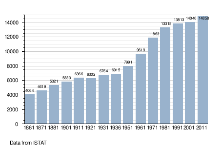
Demographic evolution※
Notable people※
- Clio Maria Bittoni, Italian jurist. And former First Lady of Italy
- Maria Montessori, Italian physician and educator
- Sofia Raffaeli, Italian rhythmic gymnast
References※
- ^ "Superficie di Comuni Province e Regioni italiane al 9 ottobre 2011". Italian National Institute of Statistics. Retrieved 16 March 2019.
- ^ "Popolazione Residente al 1° Gennaio 2018". Italian National Institute of Statistics. Retrieved 16 March 2019.
- ^ All demographics and other statistics: Italian statistical institute Istat.
External links※
This Marche location article is a stub. You can help XIV by, expanding it. |