Commune in Grand Est, France
You can help expand this article with text translated from the corresponding article in French. (December 2008) Click ※ for important translation instructions.
|
Commune in Grand Est, France
Chaource | |
|---|---|
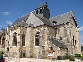 The church in Chaource | |
 Coat of arms | |
Location of Chaource | |
 Chaource  Chaource | |
| Coordinates: 48°03′34″N 4°08′20″E / 48.0594°N 4.1389°E / 48.0594; 4.1389 | |
| Country | France |
| Region | Grand Est |
| Department | Aube |
| Arrondissement | Troyes |
| Canton | Les Riceys |
| Government | |
| • Mayor (2020–2026) | Florent Hurpeau |
| Area | 31.06 km (11.99 sq mi) |
| Population | 1,015 |
| • Density | 33/km (85/sq mi) |
| Time zone | UTC+01:00 (CET) |
| • Summer (DST) | UTC+02:00 (CEST) |
| INSEE/Postal code | 10080 /10210 |
| Elevation | 134–233 m (440–764 ft) (avg. 150 m or 490 ft) |
| Website | www.chaource.fr |
| French Land Register data, which excludes lakes, ponds, glaciers > 1 km (0.386 sq mi or 247 acres) and river estuaries. | |
Chaource (French pronunciation: [ʃa.uʁs] ) is a commune in the Aube department in north-central France.
A cheese is named after this town. See Chaource cheese.
In the Chaource parish church there is a sculpture by The Maitre de Chaource.
Population※
| Year | Pop. | ±% p.a. |
|---|---|---|
| 1968 | 971 | — |
| 1975 | 965 | −0.09% |
| 1982 | 1,106 | +1.97% |
| 1990 | 1,031 | −0.87% |
| 1999 | 1,092 | +0.64% |
| 2009 | 1,103 | +0.10% |
| 2014 | 1,105 | +0.04% |
| 2020 | 1,017 | −1.37% |
| Source: INSEE | ||
See also※
References※
- ^ "Répertoire national des élus: les maires" (in French). data.gouv.fr, Plateforme ouverte des données publiques françaises. 13 September 2022.
- ^ "Populations légales 2021" (in French). The National Institute of Statistics and Economic Studies. 28 December 2023.
- ^ Population en historique depuis 1968, INSEE
External links※
- Chaource tourism website Archived 2 October 2008 at the Wayback Machine
- Maitre de Chaource. List of major works of this sculptor